
Feature
Delving Below the Surface With the Montana Groundwater Academy
Connected Science Learning January-March 2018 (Volume 1, Issue 5)
By Beth Covitt, Agatha Podrasky, Deb Fassnacht, Rebecca Paquette, and William Woessner
The Montana Groundwater Academy is a high school program that integrates classroom and field-based experiences to teach the fundamentals of groundwater science.
According to the U.S. Geological Survey, 33% of the United States’ public water supply (i.e., water that is delivered through public water systems) is sourced from groundwater. For other uses, these percentages are even higher (42% for irrigation, 60% for livestock, 63% for mining, and 98% for households that source their own water). Although communities depend on groundwater, this resource is deeply vulnerable to threats such as contamination and depletion. Concerns about groundwater are highly relevant in Montana, where 48% of the public water supply and 96% of the individual household water supply is groundwater-sourced, and where a history of industries such as mining and forestry has left a legacy of over one dozen Superfund sites with contaminated groundwater.
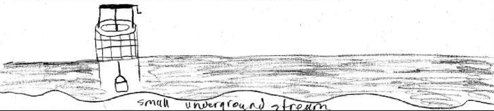
Further, although groundwater is both vital and vulnerable, most Americans are ill-prepared to understand and make informed decisions to protect groundwater resources. Common inaccurate conceptions about groundwater include that it exists in underground pipes, rivers, or lakes (Ben-zvi-Assarf and Orion 2005; Covitt, Gunckel, and Anderson 2009; Dickerson and Dawkins 2004). In one study, we found that about 65% of middle and high school students drew groundwater as existing in open underground layers, streams, or lakes (Covitt, Gunckel, and Anderson 2009). Figures 1 and 2 provide examples of responses to the prompt, “Wells get water from under the ground. Draw a picture or explain what it looks like underground where there is water.”
Figure 1
A middle school student's drawing of groundwater in pipes
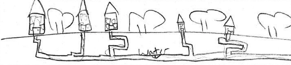
Figure 2
A high school student's drawing of groundwater as an underground stream
Other inaccurate ideas about groundwater include that it is a dead end for water rather than an openly flowing system with recharge and discharge, that groundwater is contaminated by trash falling down a well, or that contaminants seep through the ground without the need for water transport (Covitt, Gunckel, and Anderson 2009).
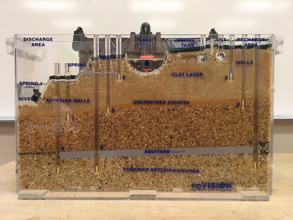
We attribute many of the challenges with understanding groundwater to the fact that it is hidden. We cannot see groundwater, and even when we do see representations of groundwater systems, they are often problematic in significant ways. For example, many diagrams in textbooks and on websites are drawn in ways that reinforce the generally inaccurate conception that groundwater exists in large, open areas underground. Also, although tabletop groundwater flow models provide a powerful tool for visualizing and investigating groundwater systems (Figure 3), these physical models are two-dimensional and are therefore weak instruments for helping students develop understanding of the three-dimensional structure and function of groundwater systems.
Figure 3
Groundwater flow model
Notwithstanding evidence of need, groundwater education is not prominent on the national science education stage (Dickerson et al. 2007). A review of the Next Generation Science Standards (NGSS Lead States 2013) highlights some issues. In the standards, groundwater is mentioned only three times, and only once in a performance expectation (MS-ESS3-1: Construct a scientific explanation based on evidence for how the uneven distributions of Earth’s mineral, energy, and groundwater resources are the result of past and current geoscience processes [NGSS Lead States 2013]). The other references are in clarification statements for two high school performance expectations (HS-ESS2-2 and HS-ESS3-1). A challenge with these goals for groundwater learning is that they require the application of previously developed groundwater understanding, and none of the over 200 NGSS performance expectations are designed to build foundational groundwater knowledge and practice. The performance expectation most closely associated with groundwater concepts is MS-ESS2-4: “Develop a model to describe the cycling of water through Earth’s systems driven by energy from the Sun and the force of gravity” (NGSS Lead States 2013). Groundwater, however, is not specifically mentioned in either the performance expectation or the clarification statement for MS-ESS2-4.
Thus, we have found that the NGSS are an imperfect vehicle for supporting groundwater education. However, although groundwater-specific disciplinary core ideas (DCIs) are not prominent, we believe the NGSS’s emphasis on three-dimensional learning that integrates DCIs, science and engineering practices, and crosscutting concepts does provide a pedagogical impetus for designing deep and worthwhile groundwater education experiences. NGSS-aligned curricula and experiences involve students in developing sophisticated, model-based knowledge and practice that can be used to explain the scientific mechanisms involved in processes and to reason about, predict, and develop solutions to address real-world issues. It is possible to develop groundwater education experiences rooted in three-dimensional learning consistent with the NGSS.
Further, we have found that schools and teachers recognize the educational and societal imperatives inherent in developing a citizenry that understands how groundwater systems work, risks to sustaining groundwater quantity and quality, and implications for decision-making. The importance of and general weakness in public understanding of groundwater led us to create the Montana Groundwater Academy (MGA). We designed the program to align with the NGSS for two reasons. First, we believe the NGSS provides powerful guidelines for designing effective instruction. Second, science teachers in Montana are seeking opportunities to enact NGSS-aligned instruction because the recently adopted Montana Science Standards are very similar to the NGSS.
For information about the history of MGA, see “Building and Sustaining a Groundwater Education Program Through Partnership” below.
Program design
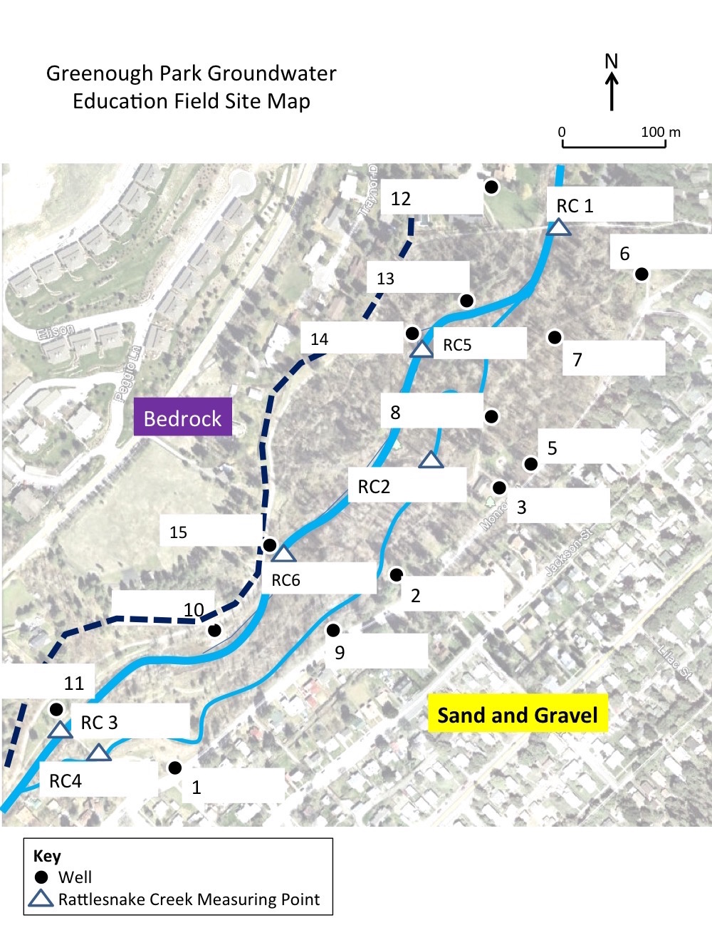
The Montana Groundwater Academy (MGA) comprises a three-lesson high school unit designed to address the need for groundwater education. The unit includes two 50-minute classroom lessons and a three-hour field trip to a groundwater education field site in Greenough Park in Missoula, Montana. All MGA activities take place during the school day. Educators and scientists from the University of Montana and partner organizations including local nonprofits, government agencies, and engineering consulting companies facilitate the MGA lessons.
MGA is designed to be implemented in Earth science courses. Because most students in Montana study Earth science in ninth grade as part of the core state curriculum, MGA is able to serve a broad spectrum of students, not just those who are interested in pursuing further studies or careers in STEM fields. In contrast, if MGA were integrated into an elective high school course such as environmental science, the participants would come from a much smaller, self-selected group of students. Thus, by engaging ninth-grade students, MGA works to develop knowledge and practice needed to make informed decisions about groundwater issues among a general population of Montana citizens.
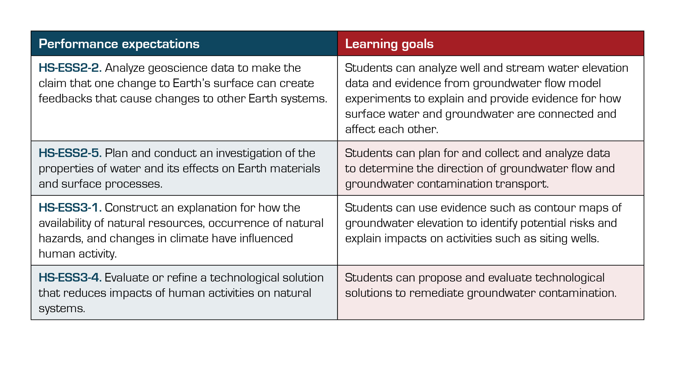
MGA addresses the NGSS performance expectations and learning goals shown in Table 1.
Table 1
MGA performance expectations and learning goals
MGA’s program design draws on a conceptual organization (Figure 4) of NGSS science practices into an instructional pattern for developing and using scientific model–based reasoning (Covitt, Dauer, and Anderson 2017). In Figure 4, practices that are prominent in MGA are highlighted in blue. Tables 2 through 4 provide a summary of MGA activities, which are sequenced to support students in building and using model-based reasoning about groundwater systems.
Figure 4
Conceptual organization for sequencing activities to develop and apply model-based reasoning
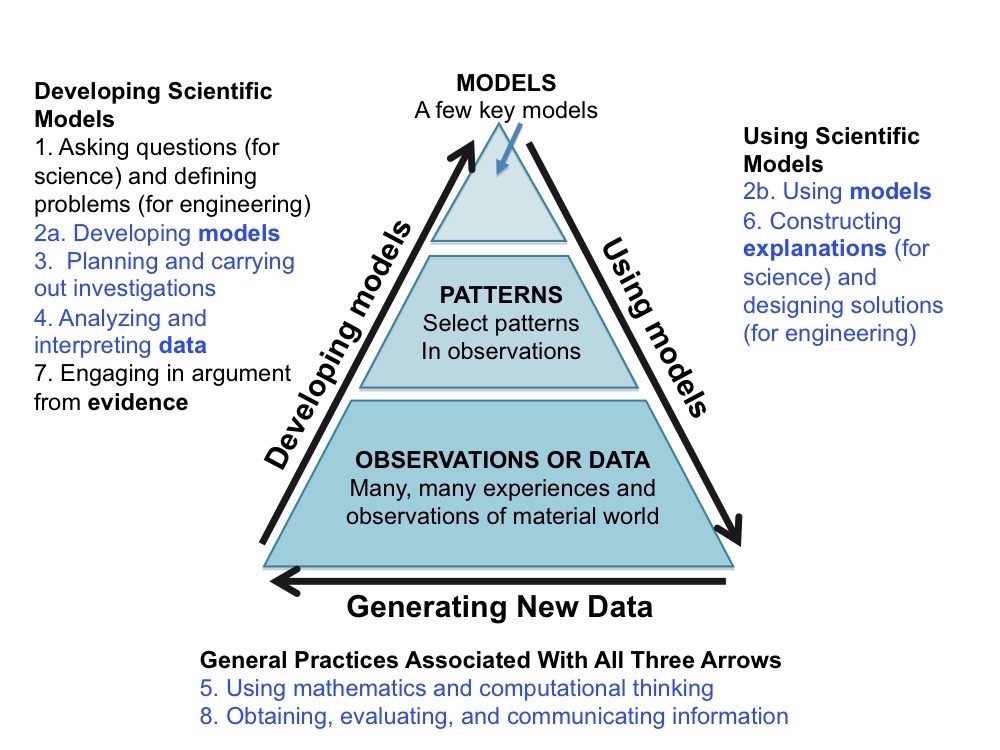
Table 2
Lesson 1: Exploring With Groundwater Flow Models (50 minutes in classroom)
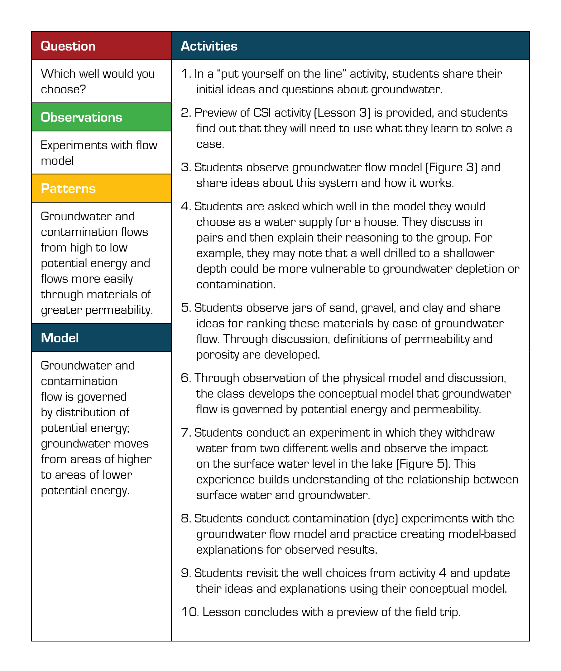
Table 3
Lesson 2: Field Trip to Greenough Park (3 hours at field site)
Table 4
Lesson 3: Application Contamination Scene Investigation (CSI) activity (50 minutes in classroom)
Figure 5
A student draws water from a well during the water level experiment
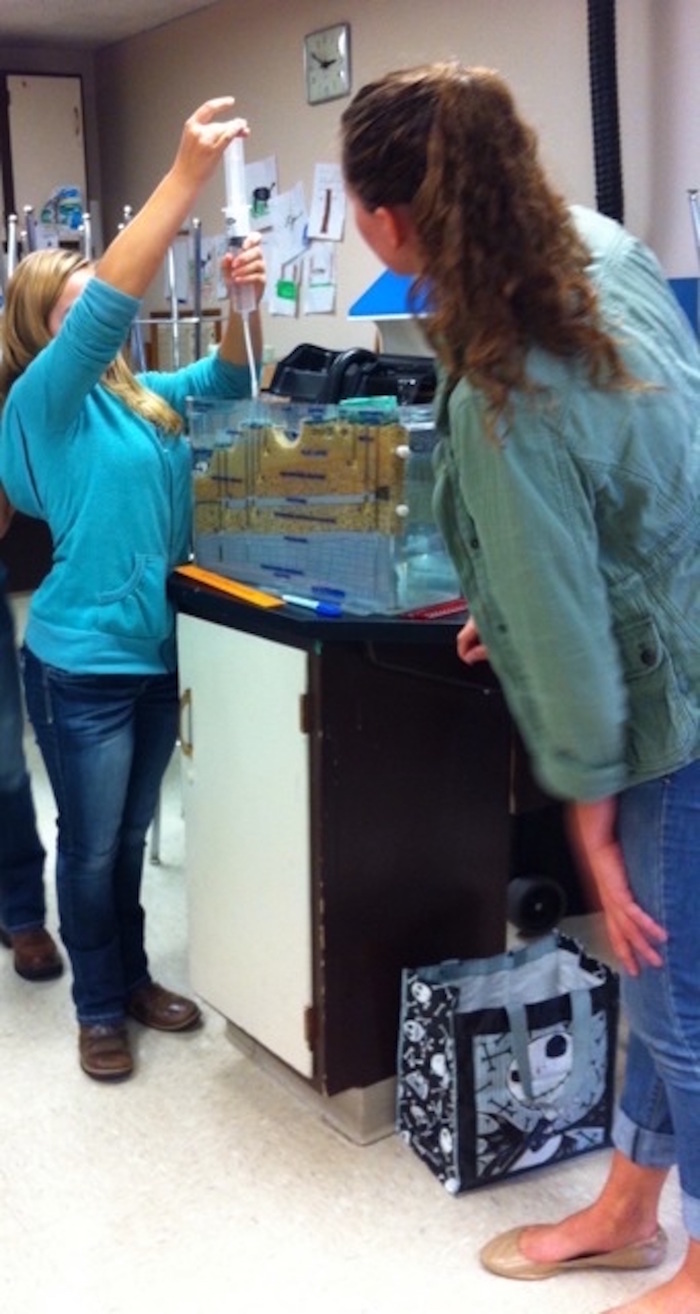
Figure 6
A student uses an electric tape to measure the distance between the top of the PVC pipe (representing land surface) and the water level in the pipe (representing the water table)
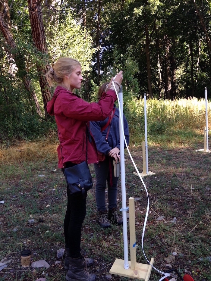
Figure 7
Students point in direction of flow in three-dimensional water table model
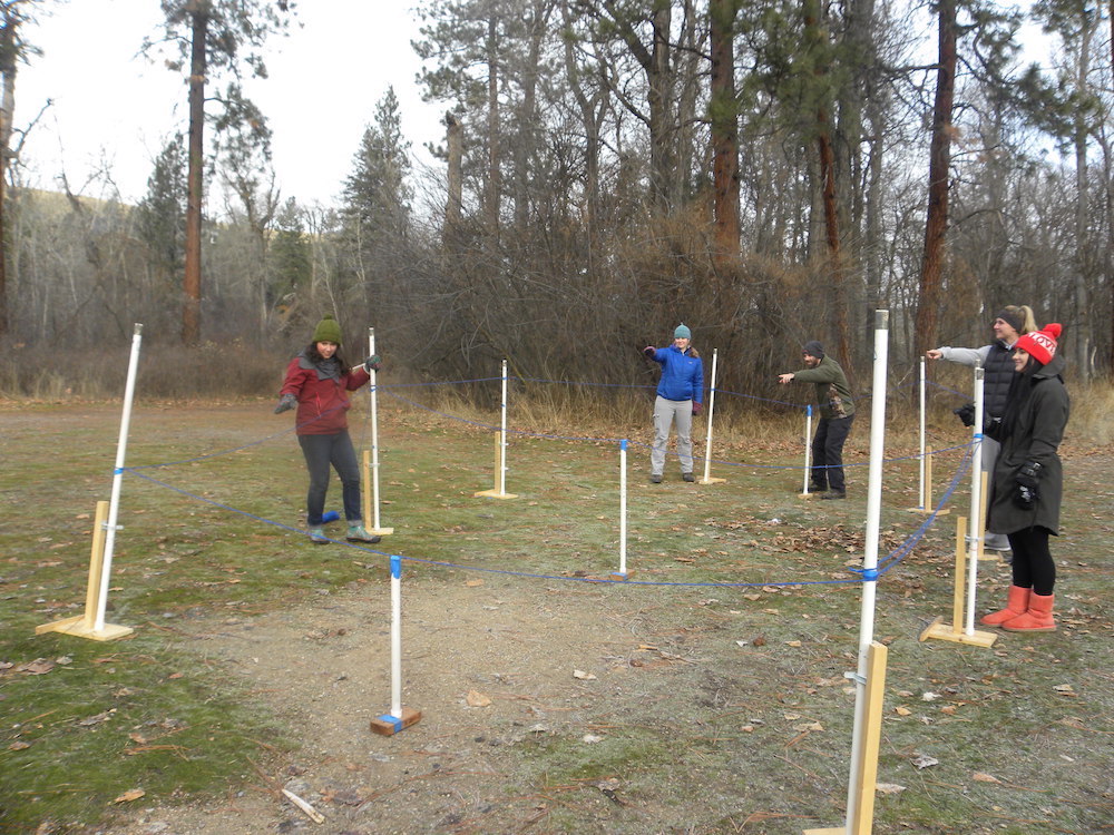
Figure 8
Students measure water table elevation in a monitoring well using an industry-standard electric graduated tape with a sensor that beeps when water is encountered
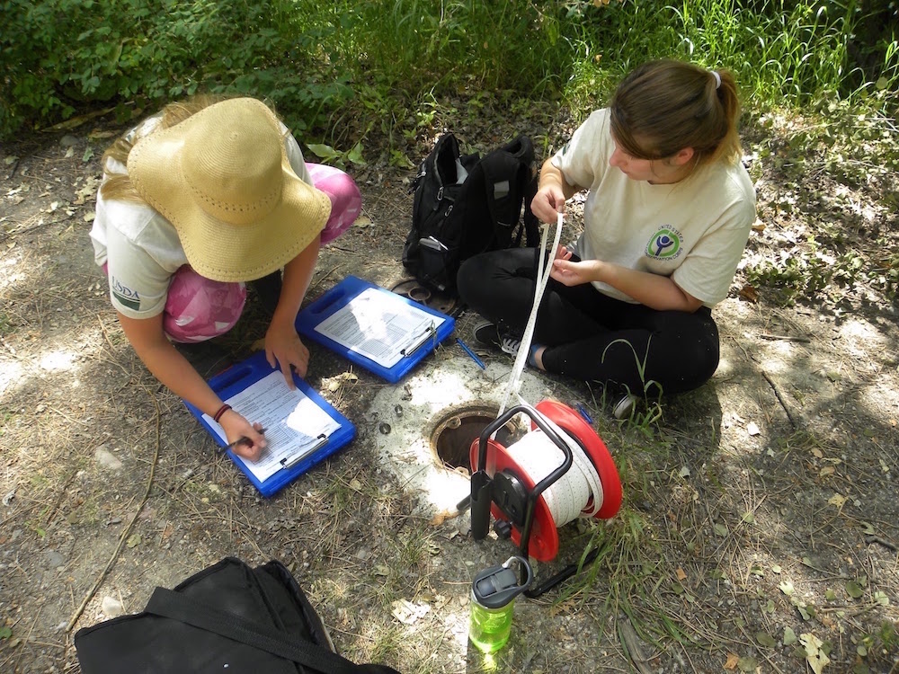
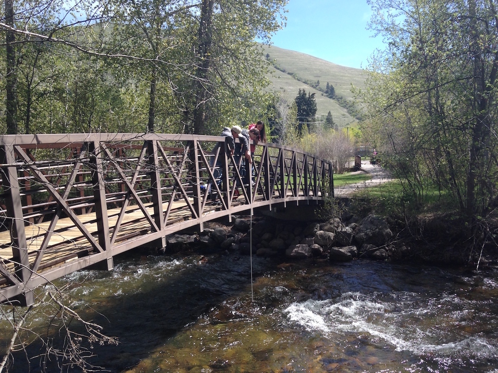
Figure 9
Students measure creek elevation from a fixed point marked on the bridge using an electric tape
MGA is designed to interweave DCIs, crosscutting concepts, and science practices to build students’ model-based reasoning. The disciplinary core idea that students grapple with in MGA is that groundwater flow is governed by distribution of potential energy in a system. Groundwater always moves from areas of higher potential energy to areas of lower potential energy. In the groundwater context, total potential energy, or hydraulic head, represents the internal energy of a fluid expressed as the sum of the fluid’s energy at a point in space due to its elevation above a known reference point (e.g., sea level) and the fluid’s internal energy due to the pressure exerted by the fluid (in force per unit area). In short, total potential energy is the sum of elevation head and pressure head, where head is a measurement relating energy to the height of a static column of an incompressible fluid. Crosscutting concepts that students apply throughout MGA experiences include tracing matter and energy through systems and system models. With regard to science practices, MGA engages students in a carefully designed sequence of experiences that involve developing and using models, planning and carrying out investigations, analyzing and interpreting data, and constructing explanations (see Figure 4).
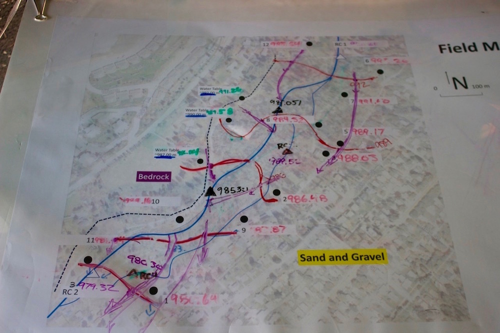
Figure 10
Field data map upon which students enter well and creek water table elevation data
MGA is also designed to respond to insights developed through learning progression research on how students understand and learn about hydrologic systems (Gunckel et al. 2012). For example, because we know students have trouble reasoning in ways that connect two- and three-dimensional representations, MGA provides experiences that help students build these connections. Students work with, create, and transition back and forth between two- and three-dimensional models and representations, including the two-dimensional tabletop groundwater flow model, two-dimensional cross-section diagrams, the three-dimensional water table model, and two-dimensional contour maps of groundwater elevation and flow direction. Overall, the MGA design aims to be responsive to ways of reasoning that students bring with them to science class, and rigorous in helping students develop sophisticated, model-based knowledge and practice.
Figure 11
Groups' groundwater elevation contour lines (red) and flow lines (purple) on park map. Rattlesnake Creek (blue line) flows from northeast to southwest.
In developing the MGA program, we have also considered issues of accessibility for students with diverse needs. For example, although well measurements are usually taken at ground level, we have a system of PVC pipe risers that can be used to raise well heights to waist level and make measuring accessible for students in wheelchairs. For classes with a student in a wheelchair, we place the PVC pipe risers on all wells so students are not even aware that an accommodation is being made. In addition, students are occasionally accompanied into the field by paraprofessional aides, who can support their participation by, for example, helping with data analysis. Overall, we try to provide meaningful experiences to all participating students by accessing students’ personal funds of knowledge (i.e., understanding and ideas that students bring with them from out of school), maximizing interactions through low student-to-facilitator ratios, and engaging students in a variety of firsthand and conceptual experiences with real-world phenomena.
Figure 12
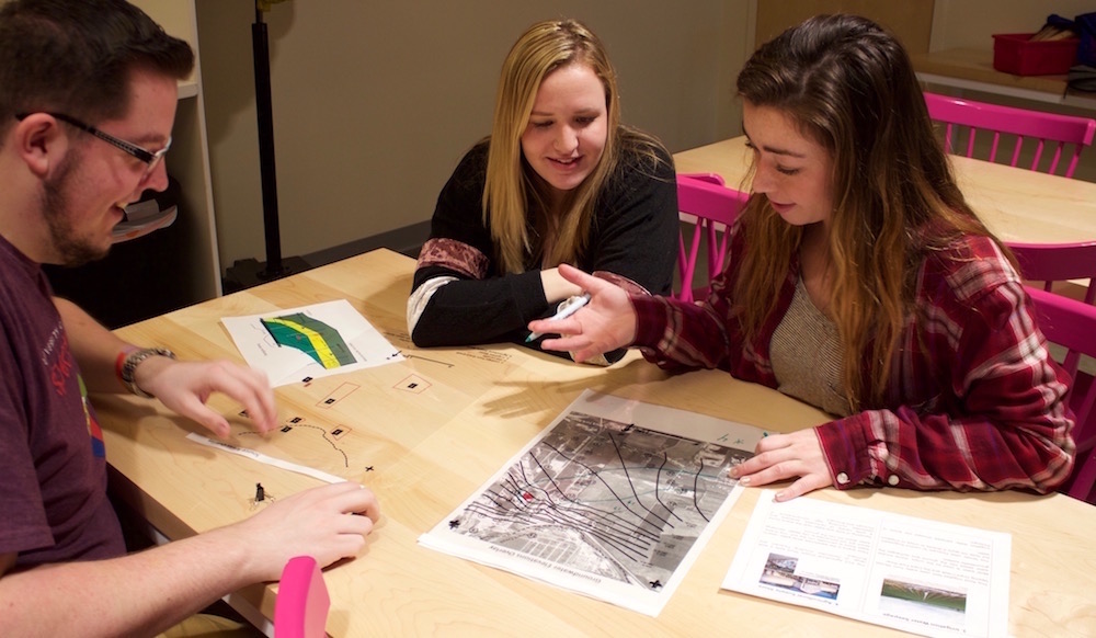
In a culminating application activity, students solve the CSI case through analyzing maps and data packets that provide evidence concerning sources of contamination, drinking water quality standards, geological and groundwater elevation data, and contamination concentration data from a subset of wells
Program evaluation
MGA program evaluation is carried out in an ongoing fashion. Approaches integrate feedback from partners, teachers, and students to support formative and summative evaluation purposes. Core program goals that are evaluated include the extent to which participation in MGA impacts students’ knowledge, practice, self-efficacy, and personal commitments related to hydrologic systems (particularly groundwater) science and protection. Because revisions are regularly made to the program, we report results from our two most recent field seasons (spring 2016 and 2017) to represent impacts of the current version of MGA. Reported results draw on pre- and postassessments completed by 241 students. About 430 students participated in MGA during these two seasons; our sample represents the subset of students for whom we had fully completed matched pre- and postassessments.
The first three assessment questions correspond with open-ended knowledge and practice items (Figures 13 and 14).
Figure 13
Cross-section groundwater question
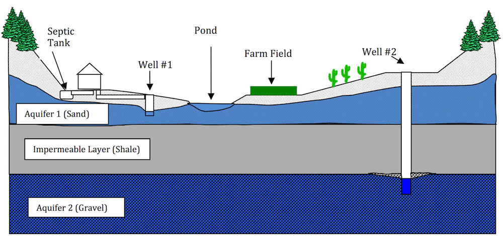
Use the diagram above to help you answer the next two questions. Assume the wells are solid pipes except at the bottom.
- How does the water get into the pond? Explain as many pathways as you can.
- Could pumping from well #1 affect the water in the pond? (Circle one.) Yes No
Could pumping from well #2 affect the water in the pond? (Circle one.) Yes No
Explain your answers.
Figure 14
Contour map groundwater question
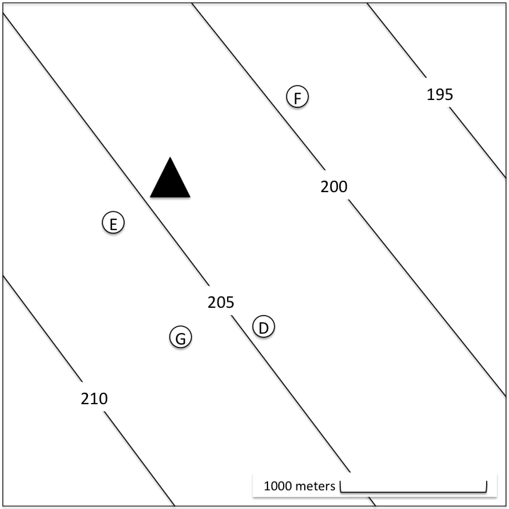 The contour lines on the map to the right show the groundwater elevation above sea level (in meters). The triangle represents a septic tank and drain field, and the circles show the locations of different wells.
- If someone installed the septic tank incorrectly and septic wastes percolated into the groundwater, in which well would contaminated groundwater most likely be detected first? Select one:
___ D
___ E
___ F
___ G
Why would contaminated water be detected first in the well you chose?
These items were scored using previously developed learning progression–based assessment methods (Gunckel et al. 2012). Each student response was coded on a scale of 1 to 4, with 1 representing the least sophisticated learning progression level of reasoning and 4 representing goal learning progression level reasoning for high school students. For in-depth descriptions of the learning progression levels, see Gunckel et al. 2012. Student responses from pre- to post- show significant improvement. On average, however, postassessment performances still represent less than the goal of level 4 model-based knowledge and practice articulated in the learning progression (postassessment means ranged from 2.28 to 2.62 on a scale from 1 to 4). Example responses representing learning progression levels 2, 3, and 4 are shown in Table 5.
Table 5
Example student responses to questions 1, 2, and 3
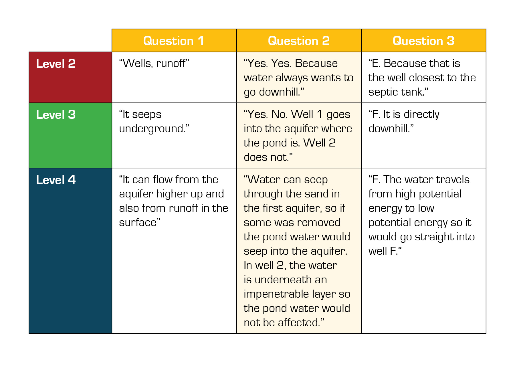
Analysis of question 2 suggests that on postassessments, some students may have reasoned that water from the surface enters the groundwater system by spilling into the tops of wells, improperly applying the idea that water moves from high elevation to low elevation (see Table 5, level 2 response to question 2). We will use our results to inform MGA activity revisions to address these types of reasoning challenges.
A summary of student results is shown in Table 6.
Table 6
Matched pre- and post-test results for MGA students

Results also showed student gains for the self-report items (questions 4–10), except for question 9, which addressed the importance of protecting water resources. A likely explanation for this result is that students’ average preassessment responses on this item were already high.
We acknowledge several program evaluation limitations. For example, in enacting MGA, we observed that the number of students who attended field trips was often fewer than the number of students participating in classroom lessons. Conversations with teachers suggest underlying issues, such as competing priorities for busy high school students. For example, because the field trip extends over multiple class periods, some students decline to participate because they will miss a different class or school day activity by going on the MGA field trip. We are curious about the effect of the field trip experience on student outcomes and plan to investigate this in the future by including a postassessment question asking students whether they attended the field trip. Overall, results have provided evidence that participating in MGA positively impacts students’ knowledge of groundwater systems and their self-efficacy for and commitment to protecting groundwater and other water resources. We continue to use evaluation data to refine the program during and after each implementation season.
Building and sustaining a groundwater education program through partnership
The MGA program was originally inspired by the GetWET groundwater observatory at Colorado State University. It took several years and multiple partners and grant proposals to move from an initial vision to constructing the field site and developing and implementing MGA. Along the way, we have experienced both tremendous support from the community and a variety of hurdles. Here, we describe a few highlights from the journey.
MGA was conceived of by a science educator at the University of Montana who enlisted the help of a hydrogeology professor and the director of a local nonprofit, the Watershed Education Network. Together, we built a cadre of partners around the community. We talked with teachers and school administrators, toured the Missoula valley looking for places to build the field site, talked with organizations about criteria and permission for building a site, and began writing grant proposals. A partial list of project partners who have supported MGA may be found on our website.
After submitting several unsuccessful grant proposals, we obtained funding from the Environmental Protection Agency’s (EPA) environmental education grant program in 2014. The EPA grant required both matching funds and subaward allocations. Matching funds were provided by our local water utility, Mountain Water Company, and by the Missoula Valley Water Quality District. (Note: In the time since MGA began, Mountain Water Company has been purchased by the City of Missoula.) Subawards were directed to local nonprofit partners to support program facilitation and to school districts to pay for groundwater flow models, field trip buses, and substitute teachers. Although the match and subaward requirements were challenging to fulfill, they also provided an impetus for making MGA a collaborative endeavor. Our partners have provided an extraordinary number of contributions, including funds, purchase and maintenance of educational equipment, field site construction consultation and oversight, education facilitation, and science role models. Without our partners, it would not be possible to implement MGA.
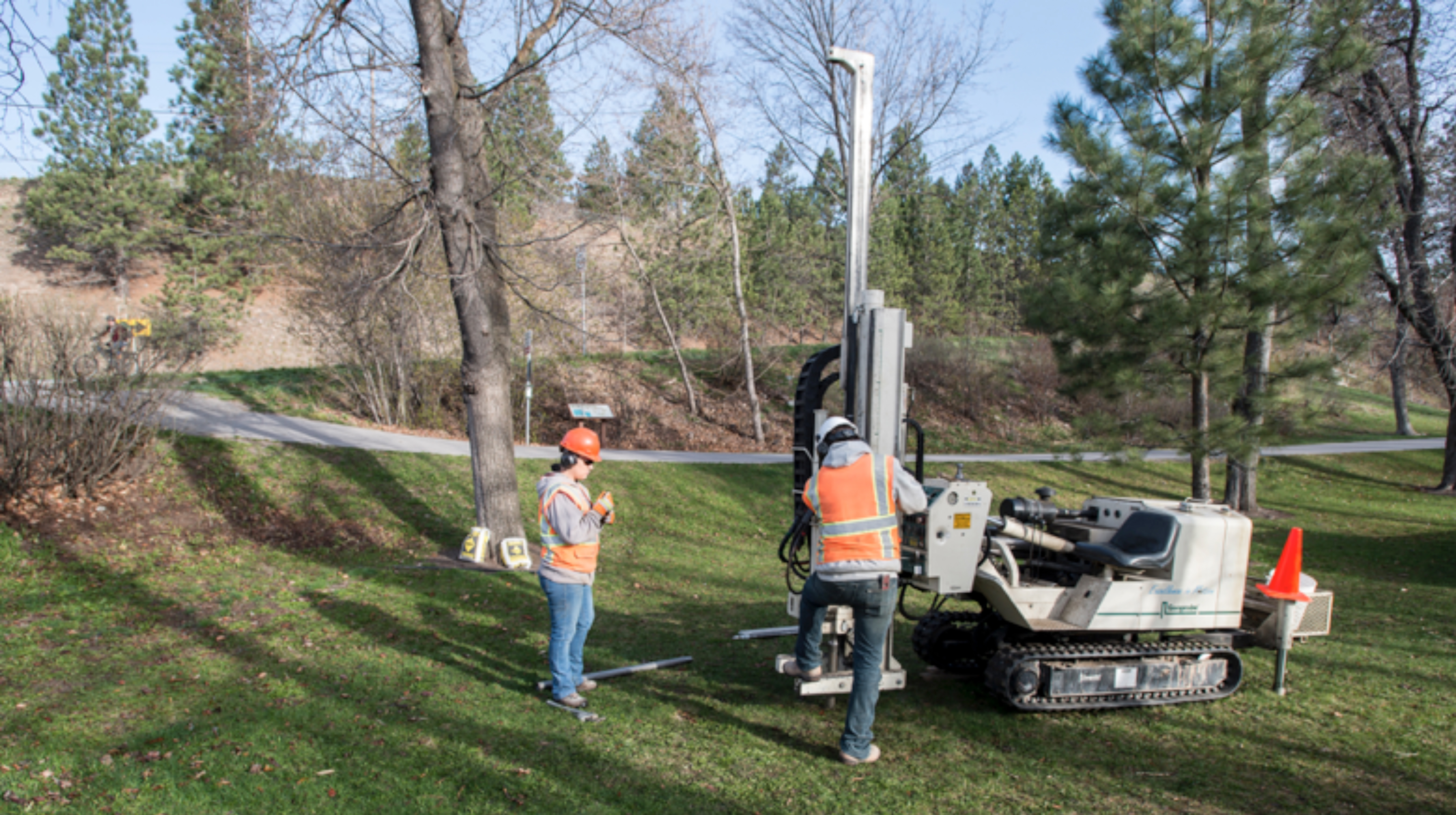
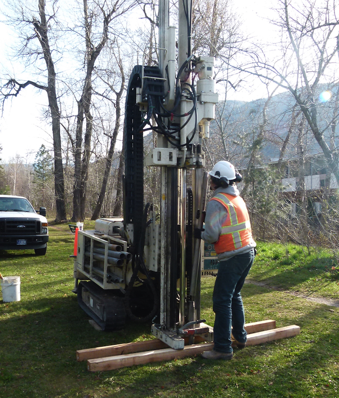
It is difficult to summarize costs for the MGA program or for developing a similar program in a different location. Costs in our case were fairly steep for a variety of reasons. For example, the site we chose was in a city park, requiring extensive time for permitting and careful efforts to secure wells (i.e., through building well casings that lock). Our particular site and geologic conditions required a Geoprobe to install the monitoring wells (cost of about $8,000). Geoprobes (Figure 15) are track-mounted machines that use a jackhammer-type drilling mechanism to install wells. Newfields, a consulting company with a local office, provided management of the site installation pro bono. Costs for site installation could be less at a site that did not require locked well casings (e.g., at an outdoor school with its own land) and that had shallow groundwater in easily penetrable substrate, which would allow for use of inexpensive, hand-installed wells. On the other hand, at a site with deeper groundwater requiring use of large, auger-style well-drilling equipment, cost for site installation could be much higher.
Figure 15
A Geoprobe is a track-mounted machine that uses a jackhammer-type drilling mechanism to install wells
Another cost consideration is that the MGA program is personnel-intensive. Because the monitoring wells in Greenough Park are spread far apart, the program field trip requires about six facilitators to accompany groups of students during the data collection hour. About two facilitators are needed for the classroom lessons and other parts of the field trip. Personnel time is also required for classroom and field site set-up and take-down tasks. Due to these and other cost considerations, reproduction of the MGA program in other locations might be well-suited for outdoor schools located in areas with shallow groundwater, where monitoring wells can be installed at a low cost and personnel are readily available for program facilitation. We recommend that organizations interested in replicating the MGA program find a local hydrogeologist with whom to partner. Because groundwater conditions can vary greatly, local hydrogeologic expertise will likely be necessary to identify a site and develop a place-based groundwater program.
Program sustainability is a core challenge. We have reached the end of our EPA grant and are exploring options for continuing MGA. We are in the process of meeting with teachers and other partners in Missoula to discuss how to adapt MGA to make it sustainable and capable of serving larger numbers of students. We have learned that it is important to Missoula schools that we provide the program, including the field trip, to all ninth-grade Earth science classes (about 800 students each year). One promising idea for serving more students with fewer funds involves collaborating with teachers to provide professional development and shifting facilitation of MGA classroom lessons to teachers. We are optimistic that with continuing support from partners, we will be able to fulfill our goal of enacting MGA with all ninth-grade students in Missoula.
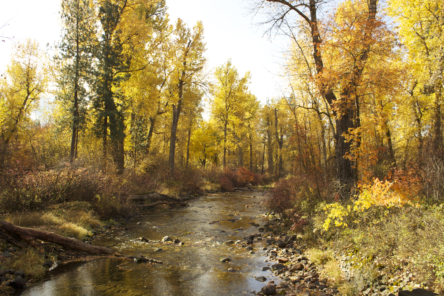
At this time, our primary goal is to sustain MGA in Missoula. There are also many possibilities, however, for development and dissemination. For example, we would like to make data collected at the field site, both by students and with installed water level sensors, more easily available to schools and the public. There are also additional types of data collection that are envisioned or being established in Greenough Park (Figure 16). The Montana Department of Natural Resources has recently installed a stream gage on the creek within the MGA field site. This stream gage station provides real-time creek data via the internet. We plan to install a climate station at the site that will also send real-time data to the internet. Sharing these types of hydrologic and climate data sets on publically available websites can provide opportunities for interested citizens to learn about, monitor, and potentially advocate on behalf of local water resources and environmental systems in informed ways. These types of data-sharing platforms also provide information to scientists, managers, and policy makers interested in long-term management and sustainability of water resources and environmental systems.
Figure 16
Rattlesnake Creek in Greenough Park
We also plan to collaborate with teachers to develop MGA lessons that engage students in using temporal and spatial data sets to investigate questions such as how hydrologic and climate conditions impact surface water and groundwater over time. Another goal is to create a public education quick response (QR) code installation. The installation would allow park visitors to use their smartphones to scan QR labels posted throughout the field site to access web-based information and activities about groundwater, surface water, and climate. Efforts to disseminate place-based groundwater education beyond Missoula are underway as well, including through a project called Comp Hydro, which is a National Science Foundation–supported education research grant that integrates computational modeling into high school students’ hydrologic systems learning.
Conclusion
The MGA program provides an example of the benefits and challenges of forging partnerships to offer education experiences that link in-school and out-of-school learning. Partners—including individuals from schools, universities, government agencies, and nonprofit and for-profit organizations—have invested time and money in MGA and recognize its value. But these same partners are all operating under a variety of pressures that make sustained support difficult. For example, at the time this article was written, the University of Montana was undertaking program reviews to adjust to serving a smaller student population. As I write this sentence, the City of Missoula has owned the water utility for three days and their continued support of MGA is uncertain. Montana teachers are transitioning to meeting new state science standards that have been adopted to align with NGSS. Because groundwater is not prominent in the standards, deciding how to include MGA in the crowded science curriculum is difficult.
We describe these challenges not to be discouraging, but rather to acknowledge and celebrate the significant achievement our community has accomplished in creating and supporting MGA. Establishing partnerships and programs that link in-school and out-of-school experiences and provide genuine field science learning opportunities for K–12 students is never easy or simple. However, problems including groundwater contamination, which students must learn about to become science-literate citizens, are never easy or simple. Over 700 students have participated in MGA, improving their knowledge of groundwater systems and how science is used to evaluate and address real-world problems. We remain optimistically invested in achieving an institutionalization of groundwater education in our state that will produce future generations of Montanans who have the knowledge and commitment required to protect the vital, yet unseen, groundwater resources that lie beneath our feet.
Acknowledgments
This work has been supported by a grant from the U.S. Environmental Protection Agency’s (EPA) Environmental Education Grants program and funding from multiple community partners in western Montana. This article was developed under Assistance Agreement No. NE-96830301, awarded by the U.S. Environmental Protection Agency to the University of Montana. It has not been formally reviewed by EPA. The views expressed in this document are solely those of the authors and do not necessarily reflect those of the Agency. The EPA does not endorse any products or commercial services mentioned in this publication. This material is also based in part upon work supported by the National Science Foundation under Grant No. 1543228 and Grant No. 1440988. Any opinions, findings, and conclusions or recommendations expressed in this material are those of the authors and do not necessarily reflect the views of the National Science Foundation.
Beth Covitt (beth.covitt@umontana.edu) is head of science education research and evaluation at spectrUM Discovery Area at the University of Montana in Missoula, Montana. Agatha Podrasky (Agatha.Podrasky@mso.umt.edu) is program manager at spectrUM Discovery Area at the University of Montana in Missoula, Montana. Deb Fassnacht (deb@montanawatershed.org) is executive director of the Watershed Education Network in Missoula, Montana. Rebecca Paquette (becca_paquette@yahoo.com) is former program coordinator at the Watershed Education Network in Missoula, Montana. William Woessner (william.woessner@mso.umt.edu) is emeritus regents professor of hydrogeology at the Univeristy of Montana in Missoula, Montana.