
Scope on the skies
Getting to the Core of Climate Change
Science Scope—January/February 2021 (Volume 44, Issue 3)
By Bob Riddle
What image may come to mind when the word glacier is heard? Before answering that question, here is another one: glaciers are part of the Earth’s “cryosphere”—so what is the cryosphere? The cryosphere includes any place on our planet’s surface covered with water in the form of snow, ice on land or sea, and permafrost. As such, the cryosphere is part of the hydrosphere and could be thought of as the “frozen water” part of the Earth.
The cryosphere plays a significant role in our planet’s climate, and an understanding of how climate has changed in the past may provide information about what to expect in the future. Scientists that study the climate history of the cryosphere (paleoclimatology) study global ice in a variety of ways, including data and observations from Earth’s orbit, flyovers with instrument-equipped airplanes, and a ground-based collection of observations and data (see Hunting for Ice on Hudson Bay in Resources).
NASA’s Operation IceBridge is an airborne flyover of the ice at both the North and South Pole. A variety of instrument-documented changes in the gain or loss in the thickness and mass of ice on land and sea as well as glaciers. Data collected by IceBridge is added to data from previous and current NASA satellite missions, ICESat, ICESat-2, and the ESA’s satellite missions Cryo-Sat and CryoSat-2 (see Resources). All the airborne and satellite missions make some of the measurements using either radar or laser altimetry. As a side note, this is the technology that allowed us to map the surface of Venus, for example (see Resources). Using either a radar or laser signal, the travel time to and from the surface is timed as the satellite or airplane passes over an area. The differences in times are converted into elevation or altitude data. With this, the height of sea ice above the level of water or the altitude of ice sheets and glaciers may be measured and used for determining the ice thickness. Satellite and airplane flyovers provide important data; however, ground-based observations and data collection is an important component to piecing together the connection between global ice and climate.
Instrumental to ground-based data collecting is the work of glaciologists and the use of core samples extracted from ice and snow fields. Like core samples taken by geologists, ice core samples and the materials they contain—in addition to the ice and snow—contain clues to the climate at the time the ice or snow was deposited. Once extracted, a core sample is only handled by glove-wearing scientists and technicians to avoid contaminating the sample as it is carefully wrapped and packed for shipment to a laboratory for analysis. In the laboratory, the core samples are often allowed to melt in a sealed container, making it possible for scientists to capture any trapped gases. The water itself is examined for particulate material like seeds and volcanic ash—anything collected from the melting ice is analyzed (see Figure 1).
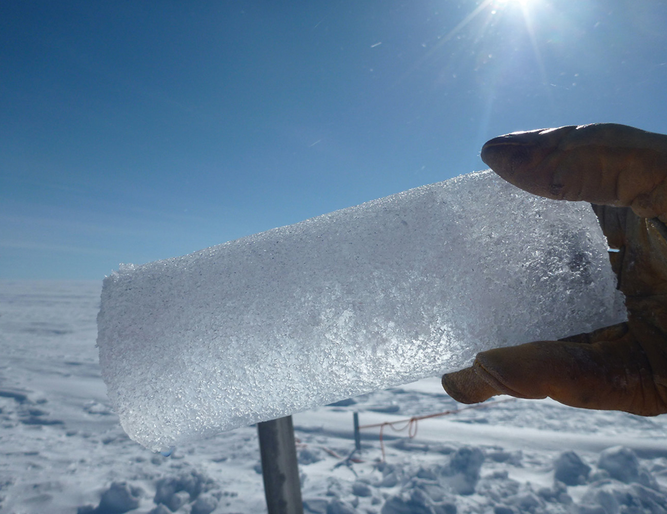
Ice core sample. (Source: climate.nasa.gov/system/news_items/main_images/2616_p1000526-1280px-90.jpg)
When the core sample gases are analyzed, scientists look for the ratio between oxygen atoms and an oxygen isotope, known as light oxygen and heavy oxygen, respectively. Students know oxygen by its inclusion in the familiar chemical formula of H2O. This is a water molecule where there are eight protons and eight neutrons in the nucleus of the oxygen atom (oxygen 16). Sometimes the oxygen atom can have more than eight neutrons in the nucleus—oxygen 18 for example (8 protons and 10 neutrons), the heavy oxygen. The ratio measured in an ice core sample is compared with a standardized ratio between the two oxygens, and the difference is used to determine trends in how atmospheric temperatures have changed. For example, a high ratio of light oxygen would suggest cooler temperatures.
Glaciers
Remember that first question: What image may come to mind when the word glacier is heard? The answer may depend on what one has seen or read about glaciers—perhaps an image of sheets of ice, like those covering the Arctic and Antarctic, or maybe a video showing calving of glaciers falling into the ocean. Many glaciers slowly make their way to lower elevations as shown in the picture taken with the Earthkam camera of snow, ice fields, and some glaciers in the Andes Mountains of the southern Patagonia region of Chile and Argentina (see Figure 2). Glaciers come in a variety of sizes based on location, and glaciers may be defined according to their respective location. Using location, there are several categories of glaciers that could be divided into two somewhat broad groups—those in mountains and those not in mountains.
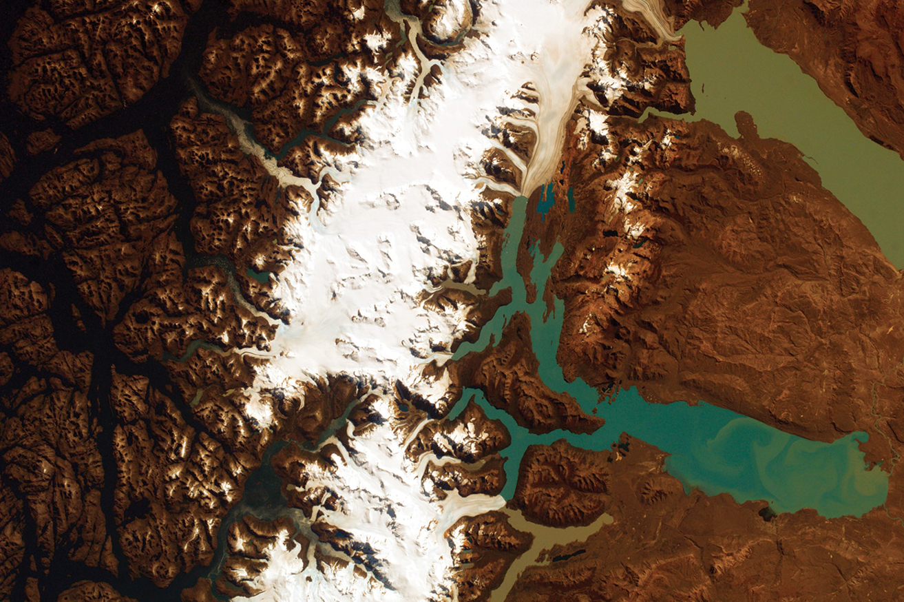
Perito Moreno Glacier, Southern Patagonia. (Source: Author using Earthkam)
Glaciers are large-scale objects that are incredible at weathering and eroding the surface of the Earth. Over time, continents are changed and mountains wear away. Ice, in terms of glaciers and ice sheets, covers approximately 10% of the Earth’s surface. Ice sheets are now only located in Antarctica and Greenland; however, in the past, ice sheets covered much of North America, forming the Great Lakes and creating the fertile soils of the Midwest and the cliffs of glacial till, loess, along the Missouri River near Mound City, Missouri.
In many locations glaciers are typically viewed from a distance—maybe aboard a cruise ship when watching glaciers calve into the ocean or driving through mountain glacier areas like the Tetons of Wyoming, the glaciers in Glacier National Park in Montana, or the glaciers of the Andes Mountains in South America. However, how often is it possible to know these bodies of ice up close and personal? Glaciers, especially the high-altitude mountain glaciers of the Andes in Ecuador, have a special and personal place in my heart (also in my feet, my lungs, my knees!). Over the years I have had several opportunities to spend time on many of the mountains in Ecuador, hiking, climbing, and scrambling on their rocky surfaces as well as traversing glaciers on some of the seven Ecuadoran mountains capped by snow and glaciers.
Sadly, many of the glaciers in Ecuador and worldwide are receding, and some are disappearing—all at alarming rates as a result of changes in our climate. Mountain glaciers, under most climatic conditions, do not really disappear but typically recede and then often regenerate themselves. However, many of the currently receding glaciers are not recovering or regenerating at a rate that balances or exceeds the rate of receding. The receding of a glacier or an ice sheet is a process known as deglaciation, and this represents the loss of a part of the cryosphere. On the basis of elevation, a glacier has a line of equilibirum, an elevation at which the amount of snow and ice accumulation is approximately equal to the amount of ablation, or loss, of glacial ice. This elevation varies based on local geographical circumstances; however, in Ecuador this elevation is at approximately 16,800 feet (5,120 m).
Two of the seven snow-capped volcanoes in Ecuador, Carihuairazo (16,486 feet [5,025 m]) and Illiniza South (15,580 feet [4,750 m]) have summits lower than the line of equilibrium and have lost or are expected to lose much of their respective glaciers over the next decade. Carihuairazo has already lost 90% of its glacier ice. It is not unusual for glaciers to grow and recede; however, studies of glaciers in the Andes show an increase in the decrease that is linked with climate change and the subsequent gradual increase in average air temperature.
It is interesting to note that the Perito Moreno Glacier (see Figure 2) is one of very few glaciers worldwide that appears to not be affected by climate change or losing mass. The area around the glacier contains approximately one-third of all freshwater in the world.
Among the glaciers of Ecuador
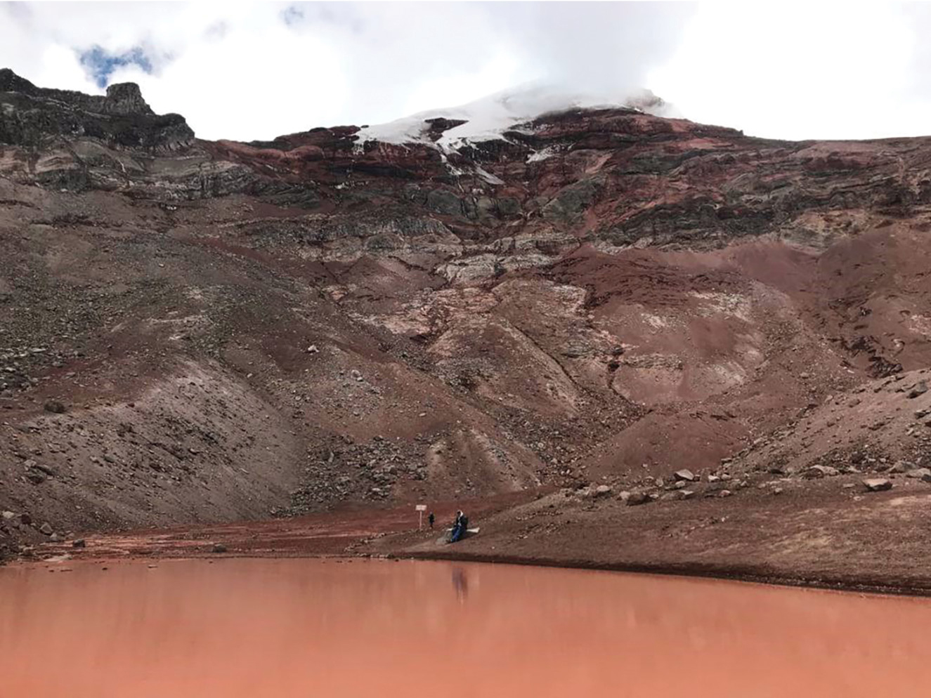
How many of us think of mountains and glaciers from a cultural perspective? How do glaciers and their tall mountain hosts fit into the lifestyles and environment of people and animals living in their shadows? As glaciers recede, what impact does this have on the environment and the people and animals living in those areas? One may not often think of glaciers in those terms, but to many people and animals the nearby glaciers are especially important. Consider that glaciers may be the primary source of water for a community, or even a source of income. In Ecuador, approximately 2% of drinking water comes from glaciers so the impact on some communities varies. However, the impact on plants and animals may be more severe as less amounts of snowfall decrease the amount of available water (see Figure 3). Much of the water source for the city of Cuenca Ecuador, for example, comes from slowly receding glaciers in the Cajas Mountains National Park. Further north, near the cities of Riobamba and Guaranda, a long-time source of income came from blocks of ice carved from the glaciers on Chimborazo and was sold locally (see “The Story of the Last Ice Merchant” in Resources).
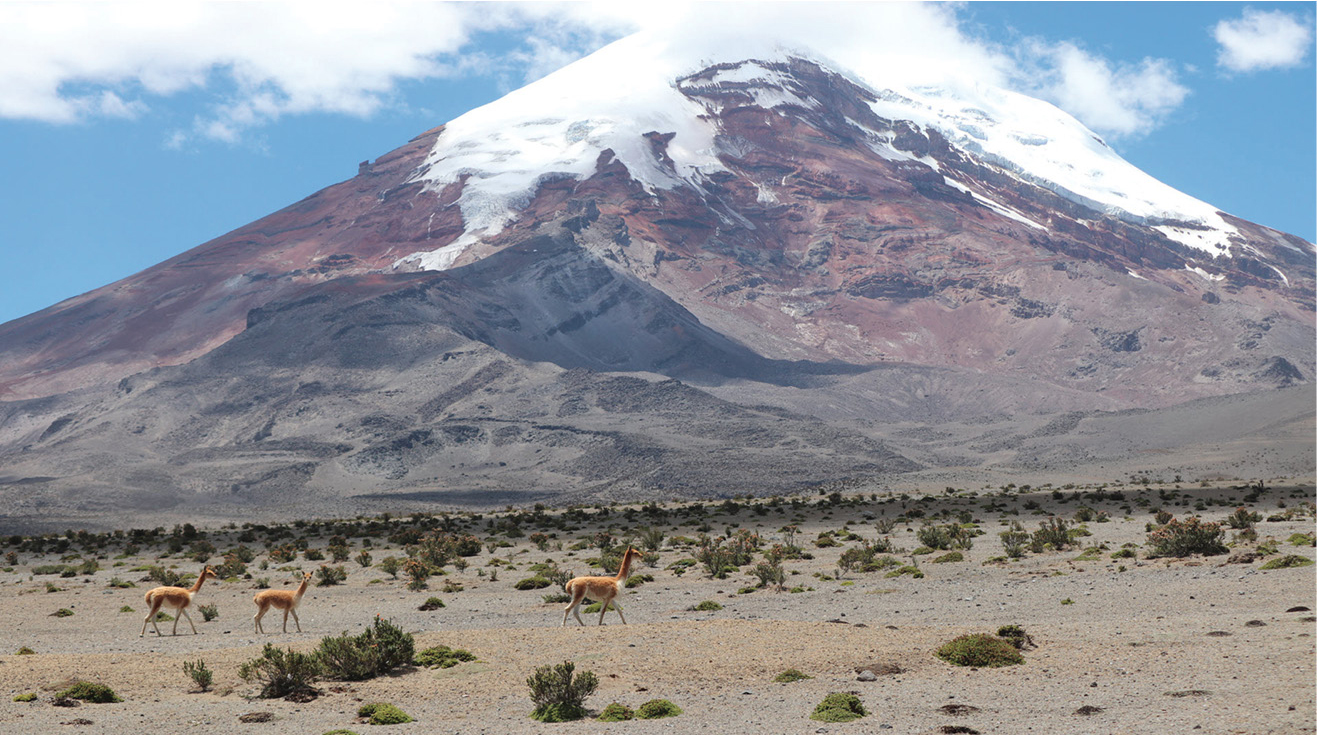
Volcan Chimborazo and three vicuna, small llama-like animals living at altitudes above 14,000 feet (4,267 m). (Source: Author)
Volcan Chimborazo is the tallest of the mountains in Ecuador at 20,500 feet (6100 m). It is one of many snow and ice-capped mountains within Ecuador. Chimborazo has the distinction of having its summit farther from the Earth’s core than the summit of Mt. Everest at 29,029 feet (8800 m). This is possible because Chimborazo, at about 1o S latitude, takes advantage of the Earth’s equatorial bulge. Over time, the rotating Earth has become slightly flattened at the poles into a shape known as an oblate spheroid. The Earth has an equatorial circumference of 24,901 miles (40,074 km), while the Earth’s polar circumference is 21,600 miles (34,762 km). Coincidentally, when students take part in an Eratosthenes Measurement project, they are measuring the polar circumference of the Earth.
Volcan Chimborazo, located within a National Park, is an easily approachable mountain for high-altitude hiking and summit attempts. The road leading to the park entrance is over 14,000 feet in elevation, and the drive or hike to the lower Refugio (climber’s hut) takes you to approximately 15,748 feet (4,800 m). From there, trails lead to the upper Refugio 16,732 feet (5,100 m) and the summit. Glacial loss on Chimborazo and other nearby snow-capped mountains is due to a combination of climate change and ash fall from active volcanos like Volcan Tungurahua south of Chimborazo. One of the most noticeable changes I have observed, especially on Chimborazo, is the reduction in the size of the glacier along one of the summit routes. This was a glacier that had carved a small
U-shaped valley ending near the upper Refugio. During my first time there in 2005, we hiked to that glacier and practiced ice climbing after crossing a small lake of glacial melt. During a visit there in 2019 the lake was still there but all that was left of the glacier were large blocks of ice covered by rocks and dirt from landslides (see Figures 4 and 5).
The small glacial lake on Volcan Chimborazo. (Source: Author)
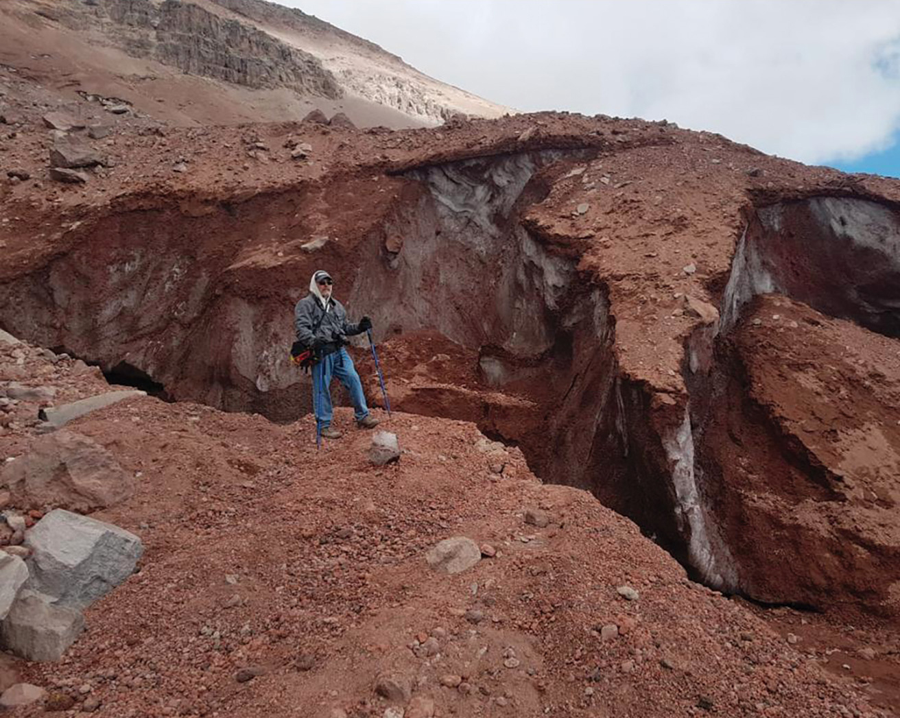
Remnants of the receded and buried glacier, elevation 17,120 feet (5,218 m). (Source: John Riddle)
The summit of Volcan Chimborazo was first reached in the 1890s by European mountain climber Edward Whymper. Among other accomplishments, he was known for his climbing of the Matterhorn and the tragic loss of several climbers during that climb. Safety is always a concern for mountain climbing, and Edward Whymper, in one of his books, offers some sound advice on that topic—advice that also applies to a person’s outlook on their education. How do you think the following quote from Edward Whymper could relate to your education: “Do nothing in haste; look well to each step, and from the beginning think what may be the end” (Whymper, 1871).
There are many resources available for us and our students that provide more information about the status and importance of ice on our planet and the impact that global ice has on climate. As I am writing this column (summer 2020), more weekly news is being reported about ice loss in Greenland and the Arctic, the thawing of permafrost, and unusually high summer temperatures north of the Arctic Circle and in many other locations around our planet dealing with rising temperatures. Students can find stories to read about the work of scientists who study glaciers and the importance of their research to the understanding of climate change at both the local community level as well as globally (see Resources for two articles from Atlas Obscura: “An Elergy for Columbia’s Tropical Glaciers” and “Glacial Research at the Third Pole”). At this time of year some of us are in locations where snow core samples could be obtained using local snow falls, allowing students to replicate some of the work that scientists do. There are also several cryosphere-related activities students could do. A good starting page to learn about the cryosphere and its components is “About the Cryosphere” on the NASA website (see Resources).
Are ice and glaciers unique to our planet? Certainly not. Images returned from space probes have shown us ice on many of the outer planet moons and in craters on our Moon and the inner planet Mercury; ice has also been seen on dwarf planet Pluto. There are polar ice caps, like those on Earth, at both poles on Mars. Some recent observations of the river channel-like features on Mars have led some planetary scientists to suggest that features like the river channels could have been formed by glaciers. •
For students
1. What types of data could an ice core provide? See Resources for links to some ice core activities.
2. What do you know about glaciers? See Resources for links to NSIDC (National Snow and Ice Data Center) website “All About Glaciers” and the “Global Ice Viewer” website.
3. Explore historical maps of glaciers at the World Glacier Monitoring Service website (see Resources).
4. Are there any glaciers in the United States? Go to the USGS website to find out (see Glaciers of North America in Resources).
5. Where is the closest glacier to you? Download the WGMS Glacier App (Android and IOS) and find out (see World Glacier Monitoring Service in Resources).
Resources
About the Cryosphere—mynasadata.larc.nasa.gov/basic-page/about-cryosphere
Climate Change: How Do We Know?—climate.nasa.gov/evidence/
Core Questions—climate.nasa.gov/news/2616/core-questions-an-introduction-to-ice-cores/
Create Classroom Ice Cores—byrd.osu.edu/create-classroom-ice-cores
Earthkam—earthkam.org
An Elegy for Colombia’s Tropical Glaciers—atlasobscura.com/articles/what-is-a-tropical-glacier
ESA CryoSat Mission—earth.esa.int/web/guest/missions/esa-operational-eo-missions/cryosat
Galileo Day—www.galileoday.org/
Glacial Research at the Third Pole—atlasobscura.com/articles/glacier-research-at-the-third-pole
Glaciers of (USA) North America—usgs.gov/faqs/where-are-glaciers-found-continental-north-america?qt-news_science_products=0#qt-news_science_products
Global Ice Viewer—climate.nasa.gov/interactives/global-ice-viewer/#/
Hunting for Ice on Hudson Bay—earthobservatory.nasa.gov/images/147086/hunting-for-ice-on-hudson-bay?src=eoa-iotd
Ice Cores: Gathering Data—betterlesson.com/lesson/635267/ice-cores-gathering-data
Ice Core Mini Lesson—info.thinkfun.com/stem-education/cool-classroom-activity-ice-core-mini-lesson
MOSAiC Curriculum Materials—mosaic.colorado.edu/mosaic-and-polar-related-lessons-and-curricula
NSIDC All About Glaciers—nsidc.org/cryosphere/glaciers/
NASA Operation IceBridge—icebridge.gsfc.nasa.gov/
NASA ICESat-2—icesat.gsfc.nasa.gov/
NASA’s Mars 2020 Rover Mission—mars.nasa.gov/mars2020/
NASA Space Laser Missions Map 16 Years of Ice Sheet Loss—www.jpl.nasa.gov/news/news.php?feature=7654
NOAA Climate at the Core—climate.gov/news-features/climate-tech/climate-core-how-scientists-study-ice-cores-reveal-earth%E2%80%99s-climate
NSF Ice Core Facility—icecores.org/
Paleoclimatology: The Ice Core Record—earthobservatory.nasa.gov/features/Paleoclimatology_IceCores
Parker Solar Probe—parkersolarprobe.jhuapl.edu/
Radar Imaging of Venus—history.nasa.gov/JPL-400-345/text.htm
The Story of the Last Ice Merchant—thelasticemerchant.com/about-the-film/the-story/
The Last Ice Merchant Video—youtu.be/PAeUC0-v5x4
What’s Causing Sea-Level Rise? Land Ice Vs. Sea Ice—jpl.nasa.gov/edu/teach/activity/whats-causing-sea-level-rise-land-ice-vs-sea-ice/
What’s the Mystery Behind West Antarctica’s Disappearing Ice?—climate.gov/news-features/featured-images/what%E2%80%99s-mystery-behind-west-antarctica%E2%80%99s-disappearing-ice
World Glacier Monitoring Service—wgms.ch/products_fog_maps/
ADDITIONAL RESOURCES ON ICE AND GLACIERS
360 Degree Images from an Arctic Expedition—poly.google.com/view/beIkmpdxevd
Dramatic Glacial Melt—climate.nasa.gov/climate_resources/4/graphic-dramatic-glacier-melt/
Glacier National Park—earthobservatory.nasa.gov/images/6399/glacier-national-park
Glacier Photograph Database (Search)—nsidc.org/data/glacier_photo/search/
Huge East Antarctic Glacier Especially Susceptible to Climate Impacts—https://go.nasa.gov/2WRVSr8
Ice in Motion—www.nasa.gov/feature/goddard/2019/ice-in-motion-satellites-capture-decades-of-change
Images of Change—climate.nasa.gov/images-of-change?id=699#699-icelands-ok-glacier-melts-away
Ice Sheets in Motion—gracefo.jpl.nasa.gov/science/ice-sheets-and-glaciers/
Ice Melt Linked to Accelerated Regional Freshwater Depletion—jpl.nasa.gov/news/news.php?feature=7669
Jakobshavn Glacier—climate.nasa.gov/news/2882/jakobshavn-glacier-grows-for-third-straight-year/
Oceans Melting Greenland—omg.jpl.nasa.gov/portal/
What Types of Glaciers Are There?—nsidc.org/cryosphere/glaciers/questions/types.html?
World Glacier Monitoring Service—wgms.ch
Bob Riddle (bob-riddle@currentsky.com) is a science educator in Lee’s Summit, Missouri. Visit his astronomy website at www.bobs-spaces.net.
Astronomy Climate Change Earth & Space Science Middle School