
feature
Exploring Earth Geoscience Processes With a Flight Over Mars
CONTENT AREA Earth-Space Sciences
GRADE LEVEL 6–8 (specific grade depends on where a state put relevant performance expectation(s) within their middle school standards)
BIG IDEA/UNIT Geoscience processes changing Earth’s surface
ESSENTIAL PRE-EXISTING KNOWLEDGE Geoscience processes can change the surface of the Earth.
TIME REQUIRED Three 50-minute classes
COST $0
SAFETY No concerns
Our planet Earth is a complex, dynamic, and interconnected system. At the middle school level, students are asked to deepen their thinking in substantial and complicated ways to make sense of how the vast variety of Earth’s features came to be, to conceptualize those features being constantly in a state of change (albeit sometimes more slowly than can be directly observed). Although all of the Earth’s system are interconnected, it may be helpful to separate geoscience processes into two broad categories—surface processes and internal Earth processes. The instructional tasks in this article primarily target the surface processes.
Among the many key foundational concepts in disciplinary core idea ESS2 Earth’s Systems, one of the central ideas for students to build ownership of is “the pivotal role that water plays across all of these global systems and surface processes” (Rivet 2017, p. 205). The series of tasks and classroom formative assessments in this article offer an approach that underscores for students the importance of water by having them explore an environment without any substantial surface water—Mars.
Prior instruction
The tasks detailed next are designed to come relatively early in a unit on geoscience processes, particularly a unit targeting the surface of the Earth. Before beginning the Mars flight tasks, you may want to take a day or two to establish some common understandings for your students. Depending on prior experiences of your students, it may be helpful to establish a broad sense of what geoscience surface processes are (something changing the surface of the Earth), and what observable evidence of those processes might look like. This could be done via a selection of photographs or video of spots around the world that show easily recognizable surface features resulting from geoscience processes.
Phenomena to explore include canyons, landslides, gullies (both large and small backyard gullies after a rainstorm), and evidence of deposition (perhaps including wind dunes, Louisiana delta created by Mississippi River deposition over time, and smaller scale deposition such as a low-lying driveway that gets soil or landscaping mulch washed onto it after a rain). In addition to learning how to recognize various surface features, students should have developed an understanding of motion (kinetic) energy of wind, water, glaciers, etc., usually done across many of their prior science units since energy is a crosscutting concept applicable across the science curriculum. Presumably students have been conversant with energy across their science curriculum to date, thus it should not be a new idea that identifying energy sources and flows of energy is a common and important aspect of thinking scientifically. With at least an introductory understanding that geoscience processes are ways in which the surface of the Earth can be changed, and some initial understanding of energy from the sun and the motion (or kinetic) energy of moving water and wind as agents of erosion, students are ready to undertake the Mars flight tasks. Consistent with principles undergirding the Next Generation Science Standards (NGSS Lead States, 2013), this Mars task is organized around making sense of a natural phenomenon (the features visible in Mars’ Valles Marineris). In addition to the content focus of geoscience, students will engage in the practice of crafting an explanation comparing weathering and erosion on Earth and Mars.
Introducing flight over Valles Marineris on Mars
Students will engage with this task in three parts (labeled A, B, and C on the student sheets; see Figure 1 for student sheets used for formative assessment purposes; see blank sheets in Online Supplemental Materials). Section A should take approximately one 50-minute class period to view the video twice with associated discussion the second time, section B should take approximately one 50-minute class period to collaboratively process energy sources on Mars with homework prior (initial ideas) and homework subsequent (students completing individual thoughts about Earth context for energy sources). Section C should also take approximately one 50-minute period, assuming you choose to have students generate initial drafts in class, with optional assistance from you, and share with peers to process and get feedback, culminating in whole-group conversation about key ideas with homework assigned to write a final version.
Student sheets for Mars Valles Marineris flight (A & B on front, C on back).
After each part, the instructional approach is to formatively assess students’ understandings, bolster and reinforce as needed, before continuing on to the next part. The distributed nature of this task (over three instructional days) offers the teacher the opportunity to support students learning with both peer interaction and teacher-guided individualized instruction. With opportunities to clarify or assist students at each of the three key segments of the task, teachers can support them as needed so they are situated to successfully attempt the next segment of the task. This is a combination of a scaffolded teaching sequence that permits differentiation as needed for groups of students and that ensures (a) the teacher gets formative information about student understandings or gaps and uses the data to inform instruction; (b) the teacher can reinforce or affirm understandings at key points during the instructional sequence before moving to the next element; and (c) all students will find adequate support to complete the series of tasks with some level of success.
Part A. Capturing Evidence for Geoscience Processes
The narrated video to be used is approximately four minutes long, produced in 2007 by NASA’s Jet Propulsion Lab, and is titled simply “Valles Marineris.” It can be found on YouTube (see Resources). Inform your students that the video will play through uninterrupted and that their task is to create a list of evidence for geoscience processes that they see or hear in the video. Part A of the student sheets in Figure 1 is where they can record just a one- or two-word term for the geoscience process (e.g., “landslide” or “gully” or “deposit of sand”). Some students may recognize “geo” as a prefix meaning “Earth” and wonder if that is the correct term for Mars. Typically scientists use the term “geology” (and all its derivatives) in a broad sense to mean the study of planets or moons, and they don’t change the term depending on which planet it is.
Valles Marineris is a vast canyon system that runs along the Martian equator.
Part B. Collaboratively Exploring Energy Sources for Mars Processes
Beginning with part B of Figure 1, the video will be played again, but each time someone (a student or the teacher if needed) notices evidence for a geoscience process, they would shout “pause” and you would pause the video there. Students would write the evidence of the geoscience process down in the first column of part B (see Figure 1) and add it to their part A list if they don’t already have it. When a student (or usually, a group of students) shouts “pause,” I ask them to describe the feature they are seeing/hearing about and why they think that might be evidence of a geoscience process (i.e., how it changed the surface). I ask others who may have shouted “pause” to raise hands if they saw the same thing, and then ask if anyone has something different. Students often engage in this energetically and even competitively to see who will identify a particular feature first, which is a helpful aspect for developing a classroom atmosphere and culture where doing and talking about science is fun and engaging. If you have some students who may hesitate to participate in this fashion, to encourage full participation you may alternatively decide to have students create their own list and share in some fashion prior to the whole-group discussion the second time through the video. One effective way to do this is to ask students to put each of their observations on a separate sticky note, and then have all students post their notes in a common location (e.g., a whiteboard or wall), aligning their observations underneath others who had the same. In this way, the students have created a class-level vertical frequency bar chart of how many times each phenomena was observed.
Before beginning the part B segment, students are informed that they will be “purple-penning” (a classroom procedure that students are familiar with) the evidence for the geoscience process list. I use purple-penning as a formative assessment process.
Students are asked to do their initial writing with any instrument and color except purple. Then when there is a time that we are reviewing/correcting/augmenting something that students have recently written down, they are asked to use a purple pen (I keep several classroom sets available and distribute them only when we are purple-penning) in class to write down anything they didn’t have the first time, including any notes to self. In this way, I can later collect student work and see both what they originally wrote as well as what they added based on group discussion. Students also get the immediate feedback as part of the instructional flow, and they can self-assess by noting what they added in purple versus what they thought of independently.
So if the video is paused at a geoscience process that the student did not document in part A, they simply write it in purple in the first column of part B. In this way, they are still situated to fully participate and document the subsequent details about that geoscience process, even if they failed to notice it the first time. This is a built-in differentiation process that helps scaffold the learning so that no student is left behind for failing to notice a particular piece of evidence in the video. If there is a concept or a part of the lesson for which many of your students used purple-penning to capture, it may be productive for you to revisit related instruction and later have students purple-pen another related task so you can determine if they have now acquired adequate understanding of that concept.
For the middle column in part B, students are not expected to have any prior knowledge of Mars, and it may be helpful for you to let them know that. Rather, this portion of the task is to offer students the opportunity to generate their own ideas first, then in a supportive manner to engage with each other as well as with you in a discussion about their thinking—you may use any classroom discourse strategies that you typically use. This approach often leads to stronger student learning because they must actively think about a specific feature and its possible causes, and then later tend to be more engaged and invested in the group discussions to explore their thinking further.
As an example of how you might choose to facilitate students completing the middle column of part B, I usually begin by leading a brief, whole-group discussion focusing on potential energy sources and other relevant variables (such as gravity) and how those might lead to the types of observable evidence of geoscience processes. I keep this very general and not about a specific feature they observed on Mars, so that students’ prior knowledge is activated but I don’t want to “steal” from them the opportunity to first think and document their own ideas. I then ask students to first write (with any color not purple) their initial ideas in the middle column of part B. After this, I typically put them into small groups of 3 or 4 where students share their initial ideas with one another and add to their ideas with purple pen (to capture what was generated in collaboration vs. what they thought of individually), and then have a small-group spokesperson share with the class. This typically results in a class-level consensus for completing (in purple pen) the middle column of part B, and you can guide or add to that discussion as needed to be sure that any concept you want students to have included is present.
If this is the first time students are asked to trace energy flow, you might choose to do this segment with the whole class if you think that they are not yet situated to have productive small-group conversations. I have sometimes done the first example with the whole group (omitting the small-group discussion) to model how to trace energy flow and how to be complete (e.g., by explicitly mentioning gravity of Mars as the force that causes the landslide mass to move down). If students are new to this kind of task, I find that it is very common for students to be less than complete in their writing.
Figure 2 shows a list of possible pause points in the video—there are some more complicated pieces such as “earthquake forces” that you may choose to skip over. Note that many of the same features are repeated multiple times in the video, but we only write/think/process a specific feature one time in the chart in part B. In sum, there are approximately four distinct features that are evidence of geoscience processes I would like students to note: (a) landslides, (b) gully, (c) valley, and (d) deposition. As noted in Figure 2, early in the video there is a brief comment about a meteor crater that we fly over. Because the narration says, “long ago …” but the visible crater still has sharp edges, this could be evidence of a lack of weathering on Mars due to a lack of surface water and very thin atmosphere. However, noting the lack of weathering would not be an expectation of mine for my students—so I sometimes choose to skip this particular feature.
List of potential evidence for geoscience processes in Valles Marineris flight.
On a few occasions, I’ve had some students note that feature, or I’ve had students that I judged would be interested in having that feature pointed out and compared with Earth craters such as Meteor Crater—also known as Barringer Crater—in Arizona, or Middlesboro Crater in which the town of Middlesboro, Kentucky is located and which is nearly impossible to identify as a meteor crater because of weathering and vegetation. Likewise, a quick reference to “earthquake forces” initially forming the entire Valles Marineris (see Figure 2 at timestamp 1:50) is also something beyond what I would expect of students. Typically, after completing part B middle column, students are asked to complete for homework the third column in part B about equivalent Earth processes and energy flow on their own so that their initial ideas are documented.
Part C. Comparing Weathering and Erosion
After students bring back their homework with the final column in part B completed, I typically purple-pen those responses with the class to strengthen any gaps in understanding or completeness. You could do this in small groups or as a whole group. If this is the first (or near first) time you are having your students incorporate descriptions about energy flow and consequent outcomes, I would anticipate that many students’ responses would be incomplete. This offers an opportune time to support student development of more complex and sophisticated ways of explaining how/why something happens to cause changes to the Earth’s surface.
For example, when explaining landslides on Earth, students may omit weathering—for example, that wind, rain, or ice weathered the rock (broke it down into smaller pieces) and that gravity was the force that caused the mass to move downhill once weakened. Even if they do incorporate these aspects, many students initially have trouble tracking the energy. I’ll ask questions like, “OK, so the falling rain can weaken rock, but how did that rainwater get up in the sky in the first place? What is the energy source?” where I’m looking for connections to the Sun’s energy evaporating water (it was then transformed into motion energy of the falling water molecules), and so forth. Or if about wind, “What is causing the wind to move?” Again, it would be the Sun’s energy which causes unequal heating of Earth’s atmosphere, which in turn causes pressure differentials and hence wind. If you have not yet taught the weather unit, students may be unable to articulate how the Sun’s energy can cause wind. You might choose to keep the explanation fairly broad at this time (e.g., “the Sun heats the atmosphere differently in different places, causing the air to move to equalize out”) and alert students that you’ll look at this in more detail in a future weather unit.
Having collaboratively purple-penned the third column about Earth processes and energy flow, all students should be reasonably well-situated to tackle the final task of comparing weathering and erosion on Earth and Mars (part C in Figure 1). If you have English learners or other students who may benefit from additional support, it may be helpful to provide scaffolds for writing the paragraph comparing geoscience processes on Mars to those on Earth, such as a series of sentence frames (starting a sentence and leaving blank where students fill in), so that you help them structure a series of sentences that can collectively respond to the prompt.
It may be helpful at this time to highlight for students the one key difference between the Mars column and the Earth column in part B—the importance of water on Earth for geoscience processes and the lack of surface water on Mars. I would ask students to individually write responses to part C (perhaps as homework). For this response, I’d be looking for students’ abilities to make a claim such as “Geoscience processes occur on Mars” in which they put together all of the ideas we had been wrestling with (see Figure 3 for a sample rubric). Figure 1 shows an example of an exemplary response by a student who chose landslides as the process to explain. Note how that response incorporates aspects of the cycling of water (MS-ESS2-4) and the concept that heating can cause expansion (MS-PS1-4), further reinforcing that the science concepts being learned in one unit are all interconnected with other aspects of understanding science.
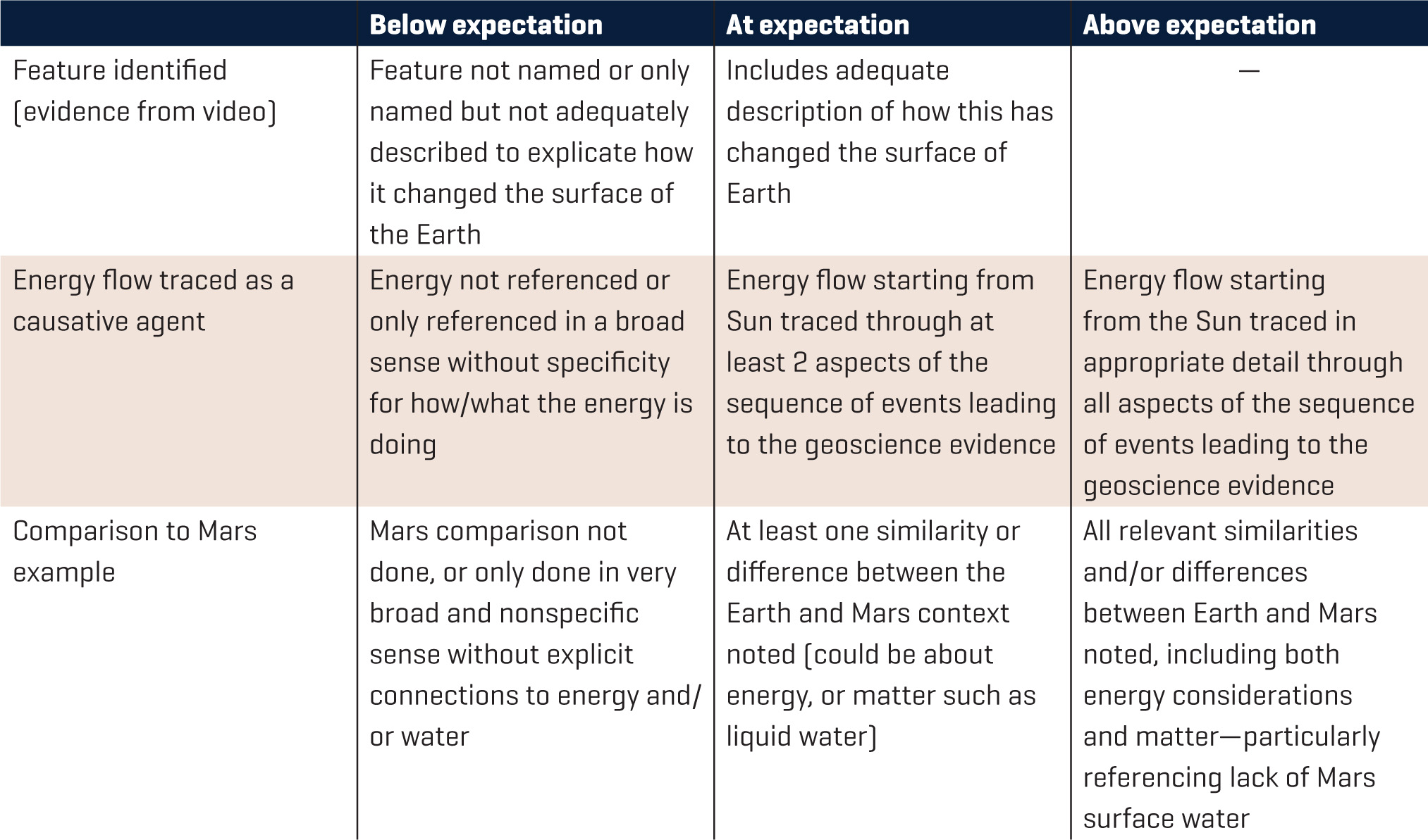
Rubric for evaluating student explanations.
Conclusion
Writing may be a challenging practice for many students, especially in a context of understanding geoscience processes that are inherently interdependent in complex, systemic ways. Using a phenomenon such as the Valles Marineris on Mars can have appeal as an exotic context, as well as actually being a simpler system than Earth because of the small amount of current geologic activity on Mars. Thus, this may be a fruitful approach for scaffolding students’ understandings and abilities to eventually learn how to construct complex, complete ideas about our own planet.
Earth & Space Science Middle School