
scope on the skies
Surface Shape Shifting
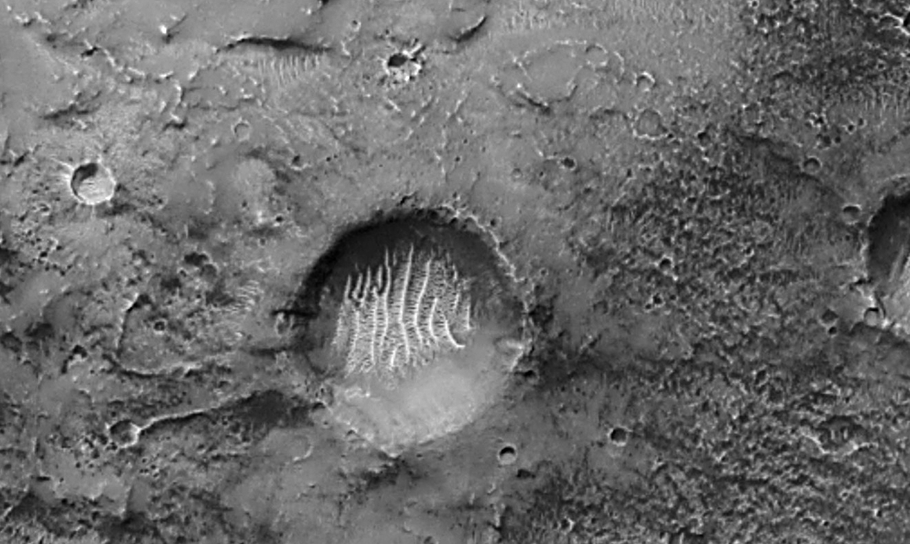
Mars Global Surveyor image of Airy-0 and nearby area (mars.nasa.gov/mgs/msss/camera/images/01_31_01_releases/airy0)
When we think about the physical processes of weathering and erosion that shape the surface of the Earth, we are also able to find similar surface-shaping processes on other worlds. Presumably, every object in our solar system undergoes some sort of weathering process, with the most common probably being meteorite impacts. However, the appearance of an impact crater will differ depending on the world the meteorite impacts. It is the worlds with an atmosphere that show the most differences. How? With an atmosphere there is the potential for atmospheric gases (winds) to move around surface materials. Most of us have experienced blowing dust or sand. One can easily feel the abrasive nature of blowing sand, so it is not surprising that winds and sand are one of the primary causes for reshaping the surface landscape.
Compare impact craters and surface features on Mars with craters and surface features on our Moon (see Figures 1 and 2). Figure 1 is part of a long and narrow filmstrip taken by the Mars Global Surveyor that shows a portion of the Martian surface. Figure 2 shows an area of our Moon with many impact craters. What do you notice? (Note: Many of the crater rims on Mars are worn down or are indistinct because of aeolian, or wind, action. Also, there may be sand dunes within some craters, and dune fields. In the picture shown in Figure 2, impact craters on the Moon do not look weathered nor are there dune fields.) Given enough time, the effects of windblown sands can wear down the relatively sharp and jagged-looking edges of an impact crater or even bury an impact crater.
On Earth and possibly on Mars, the different resistances of the rock layers will result in strange formations. This aeolian process may shape a landscape into unusual formations depending on the composition of the surface materials, leading some to look like toadstools with the most resistant rock as a cap on top of rock layers less resistant to weathering. Bryce Canyon National Park, as well as other locations in the area, are known for these toadstool-like shapes called hoodoos (see Online Resources). Add water—either moving or stationary, like an inland sea or lake—to the weathering processes, and the resulting shape of the landscape will be altered even more.
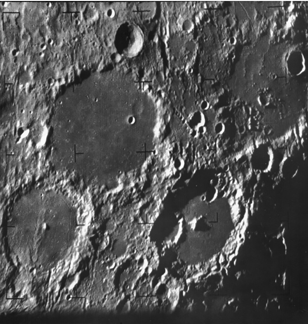
The surface of the Moon (apod.nasa.gov/apod/ap020401.html).
Some of the worlds in our solar system may have had their respective surfaces reworked through either crustal movements or by water in liquid or solid form in their past geologic history. For example, the surface of Mars has areas that resemble channels created by moving water. On some moons in our solar system, there may still be crustal movement caused by tidal or gravitational interactions with the host planet and even possibly with other moons. The surface of Jupiter’s moon Io is flexed by the gravitational interaction between Io and Jupiter and two of Jupiter’s larger moons, Ganymede and Callisto. This stress on Io creates enough heat energy to cause volcanic activity. It is believed that the volcanic activity, instead of being fueled by magma from below the surface, is due to the tidal flexing of Io’s surface. This creates the necessary heat for magma and lava to flow onto the Moon’s surface.
Where did it come from?
Sand! As most of us know it, sand is the irritating gritty stuff that is everywhere and seemingly gets into everything. It is in sandboxes and on beaches, in rivers and streams, and lining the floors of seas, oceans, and lakes. Generally speaking, sand is the product of weathering of rocks by water, and much of the sand we see is made up of a rather resistant mineral to weathering—quartz. Sand is part of the makeup of the Martian surface, but sand may not necessarily be on our Moon’s surface. However, after saying no sand on the Moon, one should consider what exactly is sand, and what types of sand there are (see Online Resources).
There is evidence suggesting there was ground water on Mars, resulting in the weathering and erosion of the surface and subsequent deposition of the materials. We see these deposition features from orbit as alluvial fans and dune fields. From our Rovers on the surface, we see these as layers deposited on the floors of what were once lakes or shallow seas. Use the Jezero Crater Interactive to explore wind and possibly water-shaped landscape within this large Martian impact crater (see Online Resources). Weathering on the Moon, however, is primarily from meteorite impacts so we could say that there is sand from weathering on our Moon. But since there is no evidence of weathering and erosion by water, Lunar sand would be different in appearance and composition from sand on our planet.
What started this column was that question about sand, and it came about while I was slogging through the colorful and deep sands of Coral Pink Sand Dune State Park near Kanab Utah (see Figure 3). With layers of white to reddish colored sandstone nearby, it seemed obvious that the sand in my shoes came from those sandstone layers. But where did the sand making up those layers come from? Fueling my curiosity were two trips (so far) to Northern Arizona and Southern Utah, where the history and effects of surface shaping by wind and water is very evident and very impressive. In this part of the Southwest, sometimes referred to as the Arizona Strip, there are many canyons and road cuts exposing layers of multicolored sandstone. When not in layers, you will find sand that has eroded from the sandstone accumulating and forming sand dunes like at Coral Pink Sand Dunes State Park and in the rounded and often unusually shaped “petrified” sand dunes forms (see Figure 4).
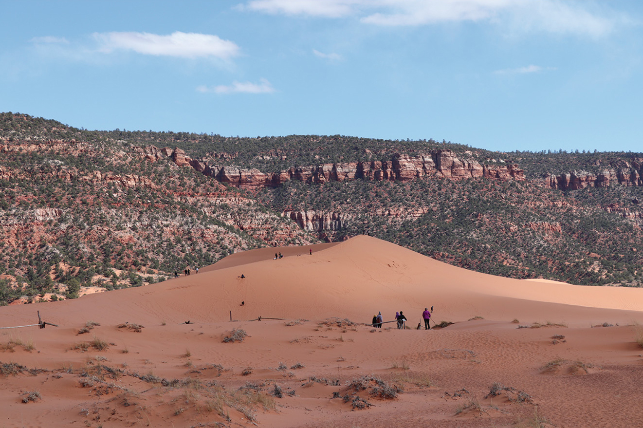
Sand dunes and layered sandstone at Coral Pink Sand Dunes State Park.
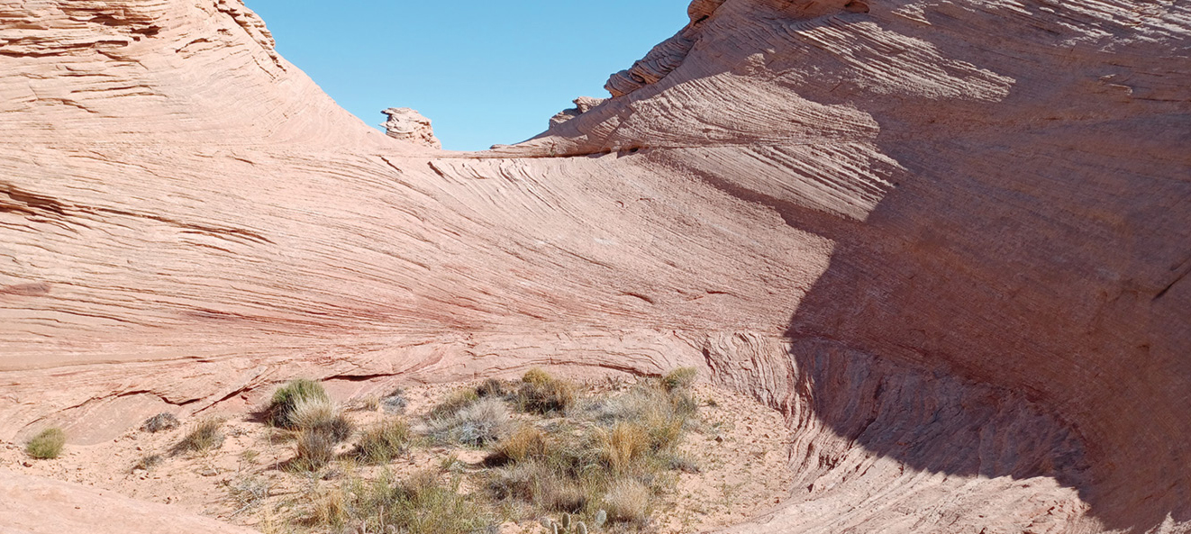
“Petrified” sand dunes and cross bedding.
So back to my question about where it all came from, which leads to learning about the geologic history of the area and the sequence of events that give us the landscape we see today. First, picture in your mind or look at pictures of the Sahara Desert, for example, and consider that this area of Utah and Arizona must have looked like it once, or maybe more than once, as there have been many changes over time. Has the land risen or subsided? It is interesting to note that if you drive from Arizona into Utah through Monument Valley, you will see that the road you are on is obviously lower than the tops of the “monuments” (see Figure 5). These are isolated remnants of what was once the floor of an inland sea or wetlands where sand was deposited and later formed into the layers of colorful sandstone. Think about it—if the sea or lake floor used to be higher and was probably a relatively level and continuous surface, then what happened to have it looking like it does now? How did the gaps and huge distances between the individual monuments come about and where has what used to be there gone? To extend this thinking a bit further, look at the image of Mars (see Figure 1). There was once water on Mars, and there still is enough of an atmosphere for winds to blow, so will we find landscape features like those in Utah and Arizona on Mars?
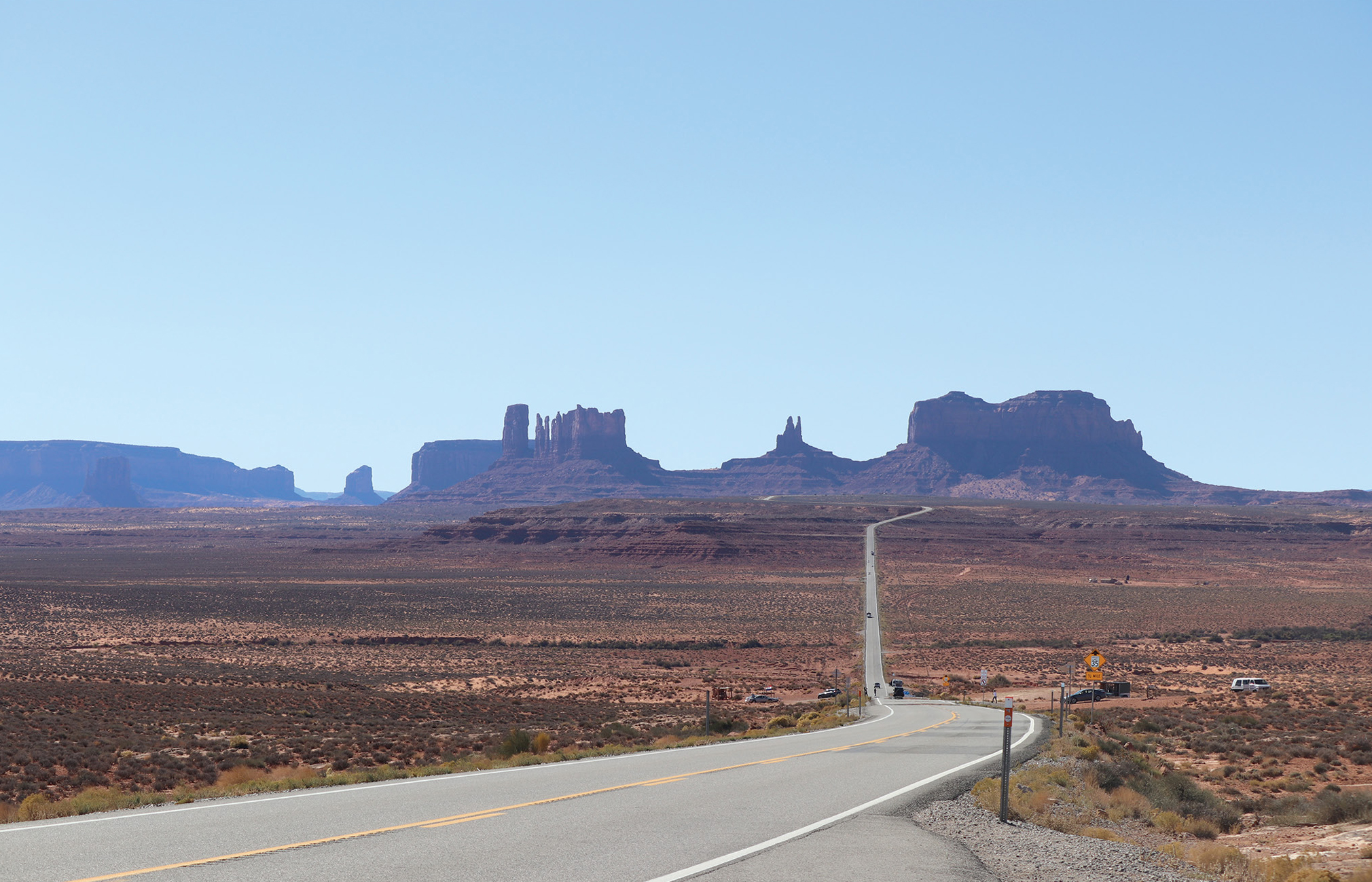
Monument Valley, looking west along Utah Highway 163.
A story in the rocks
How the sand dunes in the Coral Pink Dunes State Park formed and how sand dunes become petrified are two distinct but related stories involving wind, water, and more than 200 million years for changes to happen. During that time, from the Permian Period to the Cretaceous Period, this part of the Southwest was undergoing a series of changes that formed what is known as the Grand Staircase Escalante (see Online Resources). Sort of like the expression “wash, rinse, and repeat,” layers of sandstone are exposed either by water levels decreasing and/or by way of faulting. Once exposed, the layers are subjected to weathering and erosion until the next event that causes them to again be under water and have additional materials deposited on top. Material washed down from nearby mountains would be deposited in the lakes and shallow seas. Then as water receded, the deposited sand would be exposed. Repeat this sequence. In between, if conditions are right, winds would push the loose sand where eventually it would stop moving and start growing into dunes. Dunes become shaped by wind and water, and as the environment changes, they may become buried—only to be exposed again as the strange, other-worldly shapes that we see today (see Figure 4).
The Coral Pink Sand Dunes are unique for their location above 6,000 feet on the Colorado Plateau as well as having the second highest sand dunes after the sand dunes in the Great Sand Dunes National Park (see Online Resources). Using a mapping program like Google Earth, or with Google Maps set to show the Satellite or Terrain view, look at the area around the Coral Pink Sand Dunes State Park. Prevailing winds that blow loose sand from the Arizona Strip in an easterly direction cause it to pile up, thus forming the dunes in the state park. The coral pink color of the sand is courtesy of the weathering of the reddish sandstone forming the Vermillion Cliffs and the surrounding area.
Explore this area further by using a mapping program for taking a “road trip” (see Road Log in Online Resources) or make one of your own. Be sure to use the Satellite or Terrain view and, where available, switch to Street View and look around. Here’s a suggestion: Try starting at Bluff Utah and follow Utah and Arizona Highway 163 to Gooseneck State Park. This is a double bend in the San Juan River, much like the more well-known Horseshoe Bend in the Colorado River near Page, Arizona. Then go past the Mexican Hat formation across Monument Valley on Arizona Highway 160 to Highway 98 to Page Arizona, and then across the Colorado River on Arizona and Utah 89 North toward Kanab Utah and the Coral Pink Sand Dunes. Or near Page go south on Highway 89 to Highway 89A. Take this road north across the Colorado River and then along the 3,000-foot-high Vermillion Cliffs until the road starts climbing to almost 8,000 feet at Jacob Lake on the Colorado Plateau. Either go to the North Rim of the Grand Canyon or continue north on 89A to Kanab Utah and the Coral Pink Sand Dunes State Park. Following this route will have taken you up the Grand Staircase (see Online Resources).
There is a lot more to the story of sand, changing landscapes, and the geological history of the American Southwest, the planet Mars, and our Moon. Each of these worlds, as well as others in the solar system, are unique in their own way. As our understanding of Earth processes increases, so too will our understanding of similar processes on other worlds.
For students
1. Find pictures of impact craters on the Earth and other worlds, including planets, moons, and asteroids. How does the appearance of a crater on a world with no atmosphere differ from craters on those with an atmosphere?
2. Besides the effects of wind and water, the surface of this part of the southwest was also changed by crustal movements. Read about how Canyonlands and Capitol Reef National Parks came to look as we see them today.
3. Speaking of sand, how many stars are there in the universe?
Online Resources
Sky calendar September/October 2022—https://www.nsta.org/sites/default/files/journal-articles/Scope_SeptOct_2022/calendar.pdf
Visible planets—https://www.nsta.org/sites/default/files/journal-articles/Scope_SeptOct_2022/visible_planets.pdf
Bryce Canyon National Park—www.nps.gov/brca/index.htm
Coral Pink Sand Dunes State Park—stateparks.utah.gov/parks/coral-pink/
Coral Pink Sand Dunes Geology—www.zionnational-park.com/sdgeology.htm
Explore Jezero Crater—https://bit.ly/3biWjnZ
Geologic Map of the Grand Staircase—https://bit.ly/3ShMLKh
Geology of Great Sand Dunes State Park—https://bit.ly/3ORhQll
Geology of Grand Staircase—https://on.doi.gov/3d0Aie9
Are there more grains of sand… or stars—https://bit.ly/3BxSxSq
Great Sand Dunes National Park—www.nps.gov/grsa/index.htm
How was the Grand Staircase Formed—https://bit.ly/3OTp34a
Impact Craters activity—https://go.nasa.gov/3oH32uZ
Partial Solar Eclipse—moonblink.info/Eclipse/eclipse/2022_10_25
Road Log—pubs.usgs.gov/of/2002/0172/pdf/chap6.pdf
Sand Types—https://www.sandatlas.org/sand-types/
Vermillion Cliffs Highways Scenic Drive—https://bit.ly/3JjDYU4
Bob Riddle (bob-riddle@currentsky.com) is a science educator in Lee’s Summit, Missouri. Visit his astronomy website at https://currentsky.com.
Astronomy Earth & Space Science Middle School