
Scope on the Skies
Observing Environmental Changes from Earth's Orbit
Observing Environmental Changes from Earth's Orbit
By Bob Riddle
Astronomy throughout the year.
Our planet has many satellites in orbit providing a variety of services such as radio, telephone, and TV communications. The satellites also collect observational data that is used to study the Earth’s land, sea, and air. The data collected by Earth-observing satellites provides important information about rainfall patterns, vegetation, agriculture, population, changes in snow and ice cover, and migration patterns of land and water-based animals and plants.
Observational data collected by satellites allows scientists to track and even predict times of animal migration. This is how we know that animal migration routes worldwide have disappeared or are changing in part due to an increase in agriculture and growth of population. Climate change is also a significant component of changing migratory routes because it alters the cyclical pattern of seasons. For example, changes in the growing cycle for the vegetation consumed by migratory animals alters the timing of the animals’ migration.
Tracking zebra migration
Each year, a herd of zebras embarks on a 580 km (360 mi.) round trip across the African country of Botswana. The migratory route follows the cycle of rain and growing vegetation. The route passes through a watery inland delta formed by the Okavango River in northern Botswana and continues southeastward to the Makgadikgadi Pan, one of the largest salt flats in the world that contains remnants of the old, dried-up Lake Makgadikgadi.
During research conducted at the Okavango Delta, scientists learned that, in the past, a herd of zebras from the Delta area would migrate to the salt flats of the Makgadikgadi Pan at the start of the rainy season in September and remain there until the following April before returning to the Delta area. That migration came to an end in the late 1960s when fences were erected to prevent disease-carrying water buffalo from infecting herds of cattle. Thirty-six years later, however, the fences were removed, and in less than three years, the zebras were following the same migration pattern as they had in the past, beginning at the start of the rainy season.
In this area, zebras live an average of 12 years, so the current herds could not have learned about the migration route from their immediate predecessors. Scientists in the area studied this by combining GPS data from tracking collars on male zebras with daily satellite imagery of rain and plant growth. The scientists concluded that over time, as zebras explored their new open spaces, the zebras developed the migration route by following the rains and the growth of edible vegetation toward the salt flats of the Makgadikgadi Pan. To develop the migratory route, the zebras used what the scientists call environmental cues—the starting and ending of the rainy season, for example.
The significance of this study shows that as climate changes alter the timing of events such as the rainy season, animals and plants could adapt to the changes. On the other hand, many do not adapt successfully to environmental changes and are threatened with possible extinction.
Temporary wetlands for migratory birds
Migratory birds flying along the western coast of the United States during the fall and spring seasons take routes to and from the Arctic Circle, Mexico, and Central America. Many birds take breaks at wetlands from their long flights south or north. However, these wetlands are gradually disappearing due to urban growth and agricultural demands, reducing the resting and nesting places for migratory birds.
In California, the Bird Returns Program (see Resources), a cooperative effort between the Nature Conservancy and the California Rice Commission, helps rice farmers throughout central California create temporary wetlands for the migratory birds by flooding rice fields at certain times of the year. Scientists used studies to locate and know when to flood certain rice fields and analyzed more than a decade of Landsat imagery to develop a cyclical pattern of when temporary bodies of water, wetlands, and rivers appear and to follow bird migrations to determine regular stopping locations. This was combined with ground-based observations of the numbers and types of birds and their migratory routes.
Farmers can participate in the Bird Returns program by submitting an application to the California Rice Association. Rice farmers receive financial compensation for flooding their fields to create temporary habitats for the migrating birds. There is a short, eight-minute video at the Bird Returns website (see Resources) that explains the program from the perspective of the farmer and the conservancy scientists.
April
May
Extinction at the Atacama Desert
The Atacama Desert, located in northern Chile between the Andes to the east and coastal mountains to the west, is the driest desert in the world. According to records, there has not been a measurable rainfall in the area for at least the last 500 years. Considering the hyper-arid conditions and a soil containing salts and nitrates, microorganisms have flourished. These extremophile microbes have adapted to minimum amounts of water. However, changing weather patterns over the Pacific Ocean have brought three episodes of rain since 2015 to the Atacama Desert. The rainfall created temporary lakes in many of the low-lying areas, and it led to widespread extinction among microbes that had adapted to the hyper-arid conditions. Studies of microbial life in typically dry areas found at least 16 different microbial life forms. In the temporary lakes, the extinction rate was 85%, leaving only a few types of surviving microbes.
Extinction was through a process called osmotic shock or osmotic stress, in which the organisms are suddenly in a water environment where, from the soil, there are dissolved chemicals such as salts and nitrates. Osmosis is a process that causes an increase in water loss from a cell when the concentration of dissolved salts surrounding the cell increases. The exposure to a more saline environment causes the cells to lose water through osmosis, which in turn causes the cell to die.
The Martian connection
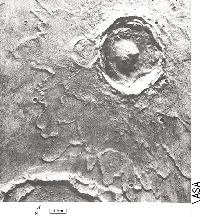
Interestingly, the planet Mars is also a hyper-arid environment. In its past, it is likely that there was standing surface water on Mars long enough for stratified layers of rocks to be deposited. There were also several episodes of large-scale catastrophic flooding caused by the sudden melting of permafrost from meteorite impact. Yuty Crater on Mars, an 18 km (12 mi.) diameter crater, is an example of a splat crater resulting from a meteorite impact on Mars in an area that contained permafrost. The heat released from the impact caused the permafrost to melt and flow outward from the impact site. The resulting mud-like slurry formed the lobes around the crater (see Figure 1).
Using the changing conditions at the Atacama Desert as an example, scientists have speculated that there may be evidence of life on Mars in the areas where there was once surface water. Assuming life on Mars was microbial, Martian life would also require water, so it makes sense to explore those formerly wet areas. The life on Mars could also have adapted to harsh arid conditions like the Atacama Desert, albeit much colder. If there were life on Mars adapted to arid conditions, it may have been wiped out by the periodic flooding much like what has recently been happening in the Atacama Desert.