
Scope on the Skies
Earth Watch
Science Scope—May/June 2021 (Volume 44, Issue 5)
By Bob Riddle
It is highly likely that everyone has a favorite, memorable quote that has played a role in their thinking about things. As an inhabitant of the planet Earth, and as an Earth/space science teacher, I have many quotes tucked away that I would occasionally share with students. Some quotes came to mind that seemed apropos while I was planning for and writing this column about ways we observe our planet from orbit—for example, monitoring how environmental changes over time can influence local and global weather patterns or help us understand and plan for future land uses. But as sometimes happens, my thinking and writing journey changed direction and, as a result, so did the column topic. The topic is still about observing our planet, but perhaps not exactly how you might think observing has been done. Here are some of those quotes:
“It is our home, our only home.” (source: possibly the Dalai Lama)
“We shall not cease from exploration, and the end of all our exploring will be to arrive where we started and know the place for the first time.” (source: T.S. Elliott)
“Science today was Science Fiction when I was your age” (source: my late father)
I have always been an avid reader, and growing up in a house where the bookshelves were filled with science fiction and where my late father wrote, edited, and published what he called “Sci/Fi Fantazines” had an influence on me (see Resources). Some stories, for example, followed the aftermath of a life-threatening ecological event or a political situation, with people colonizing elsewhere in the Solar System. Books I read took me to Mars, Venus, our Moon, asteroids, and moons of other planets, where to survive we brought our Earth environment with us but adapted it to local conditions. In these stories people lived under protective domes, below the surface, as well as above the surface perhaps following terraforming endeavors. In many of these stories, coping with an inhospitable environment that included planet and space-based weather unique to the location required people to constantly modify or adapt to any changes (see Figure 1). But that is science fiction, whereas the issues facing us and our home environment, the Earth, are science. With Earth observation programs from NASA, other space agencies, and governmental agencies like the National Oceanic and Atmospheric Administration (NOAA), the United States Geological Survey (USGS), and even the Central Intelligence Agency (CIA) (see Resources), we are constantly monitoring our home environment, alert for environmental changes and also weather and climate changes on a local and global scale.
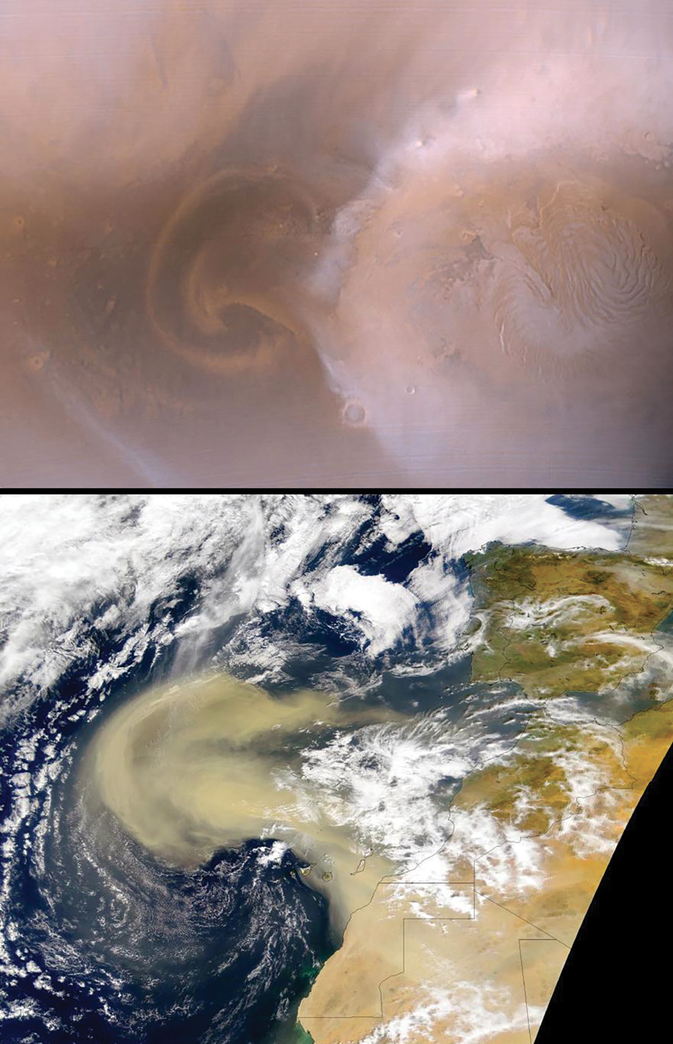
Recent Mars and Earth dust storms compared
For students
1. Read the New York Times article about Linda Zall’s use of Corona images for the CIA (see Resources).
2. Ever read a declassified and redacted Government document? You can now read about the development of the Gambit and Hexagon programs (see Resources).
3. Visit the NOAA website and view satellite imagery of the Earth in real time, or view the Earth using different data sets (see Resources).
I’ve got an eye on you!
Our planet is routinely observed and studied from Earth’s orbit. Under the umbrella of the NASA Earth Science Division (ESD) there are numerous missions with a focus on observing our planet and providing data useful in many applications including tracking changes in the environment and helping to predict weather patterns that may lead to severe weather events. Data is collected from Earth’s orbit using satellites operated by space agencies from several countries, the International Space Station (ISS), airborne observatories, flyovers using balloons, and even drones. Data is varied and includes land cover and use, information about sea-level changes, snow and ice cover, ocean and atmospheric currents, and water resources. From these data and observations, we can monitor natural changes as well as the impact changes we have caused to the environment (see Resources).
There are programs like the Landsat program, Earth Observatory, and NASA Global Prediction, Monitoring, and Response that provide, in some cases, decades of images and data that are being used by scientists to study changes on our planet occurring over relatively long periods of time. All of which adds to our better understanding of the interconnection between changes over time and what we may expect in the future. This could be in terms of just about anything imaginable, such as the different ways deforestation can affect weather patterns. For example, a study by the University of Leeds noted that plants and trees release different gases in addition to oxygen. Some of these gases react with chemicals in the atmosphere, forming microscopic particles that reflect the sunlight and result in a cooling effect. The study also found that during the process, there is a warming effect as an increase in carbon dioxide and even methane occurs. However, in the tropics where the study was conducted, the cooling is somewhat balanced by the warming. The overall net effect, the study noted, was that from large-scale deforestation changes in local weather patterns, and over time the loss of vegetation could cause changes in climate (see Resources).
While we are familiar with Earth-observing programs operated by NASA, USGS, and NOAA, the CIA has long been involved with observing our planet. During the United States and the former Soviet Union (USSR) Cold War years, both countries utilized a variety of satellites and high-flying airplanes—like our country’s U2 spy plane—to observe each other by taking pictures and videos. Many of the pictures that were taken by our side were of Soviet missile sites and military bases, but images also include the surrounding countryside. These images, as well as images from similar programs, have become the source for information on how the areas have changed over the years and what effects these changes may have had or are currently having on the environment.
One of the oldest programs and the first to use satellite imagery was the Corona Program, operated by the CIA (see Resources). This program was proposed by President Eisenhower in 1958, and it was the first of 145 launches started in 1960. Accompanying the Corona mission were two additional programs, ARGON and LANYARD, that mapped image data and provided somewhat higher quality images, respectively. The Corona satellite was placed in an orbit at an altitude of approximately 100 miles, and each frame of a picture covered an area of approximately 10 × 20 miles. Once the roll of film was used, the 20-pound canister would be dropped into the atmosphere and a parachute would slow its fall. The canister would then be snared in midair by an airplane and returned to the ground for film processing (see Figure 2). There were 125 Corona missions with successful canister returns over the years until the program was stopped when the satellite images could be returned from orbit digitally. A few years later, many of the images were declassified and became available, giving scientists a longer timeline from which to observe changes in the Earth’s surface, and in many cases, to make predictions about future changes to the planet.
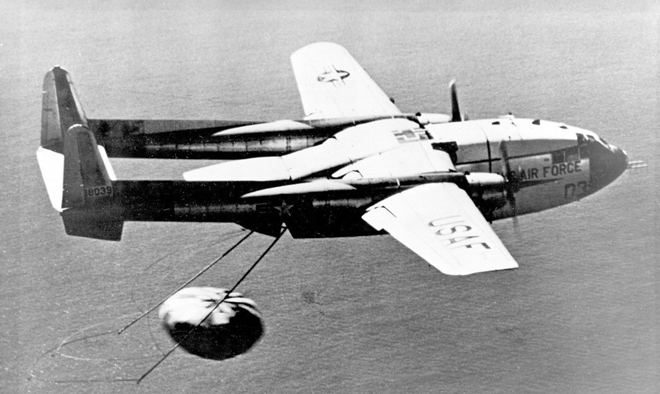
Fairchild C-119J Flying Boxcar recovers CORONA capsule.
Orbital reconnaissance missions continued, and as photography technology got better, so did the ability of these satellites to take more detailed images, primarily of military sites. The predecessor, the Corona mission, took wide field images that lacked good detail. The following missions operated by the National Reconnaissance Office (NRO) and launched by the U.S. Air Force included the Gambit and Hexagon satellites. These satellites took images that were of much higher resolution but were still film based and were also returned by parachute. The cameras used on the Gambit satellite carried between 3,000 feet and 12,000 feet of film in five- and nine-inch widths. The Gambit satellite orbited in altitudes ranging between 65 and 100 miles, and the cameras were capable of a two-foot resolution. Objects as small as two feet in size could be seen. Cameras could take pairs of images slightly offset from each other so they could be viewed as a stereo pair with a 3-D appearance. The Hexagon satellites used new and improved camera systems capable of carrying six-inch-wide film in lengths up to 60 miles. Much depended on the camera in use. The panoramic camera, for example, could image an area that was nearly 400 miles wide and with a resolution that ranged from two to three feet to a much wider resolution of 30 to 35 feet. And as with the Corona program, the imagery provides useful information for more than just military intelligence use (see Resources).
Environmental intelligence
So how did spy satellite reconnaissance imagery become a resource tool for Earth scientists and others monitoring our planet? In 1990, then Senator Al Gore, a concerned environmentalist, asked if the CIA’s surveillance resources could be used to monitor environmental changes. He said that these satellites “recorded much more than the landscape of the Cold War. In the process of acquiring this priceless data, we recorded for future generations the environmental history of the Earth at least a decade before any country on this Earth launched any Earth resource satellites” (see Resources).
This led to reassigning CIA scientists, in particular Linda Zall, who answered that question by writing a classified report originally published in the New York Times titled “Spy Satellite Photos May Aid in Global Environment Study” (see Resources). Perhaps for security reasons at the time, it was not unusual for the CIA to use “mystery writers” pseudonyms in place of the real authors’ names, and therefore Linda Zall’s name was never mentioned as the author of that report. Following the report, the Measurements of Earth Data for Environmental Analysis (MEDEA) team was formed. This group of Earth scientists and others, led by Linda Zall, was allowed access to study CIA surveillance images. The MEDEA program ended in 2015 and has since been replaced by programs that utilize satellites with much improved imaging technology. “Environmental intelligence” is of significant importance and value because “environmental trends, both natural and human-made, are among the underlying forces that affect a nation’s economy, its social stability, its behavior in world markets, and its attitude toward neighbors” (see “Environment on the Intelligence Agenda” in Resources).
Our only home
The planet Earth is currently the only place where we can live, and just like our homes, classrooms, and local communities, there is a constant need for environmental awareness. This should highlight both the importance of thinking globally while dealing with local circumstances and the importance of monitoring our “home” from a global perspective (see Figure 3). Given the satellite-observing technology of today, we are increasingly getting to know our home, the Earth. Conversely, if we do not try to learn more about Earth, we will never really understand the synergism between the Earth and its inhabitants. We learn by exploring and observing, so there may be no end to that exploration. Nonetheless, the result will be to know our home better. •
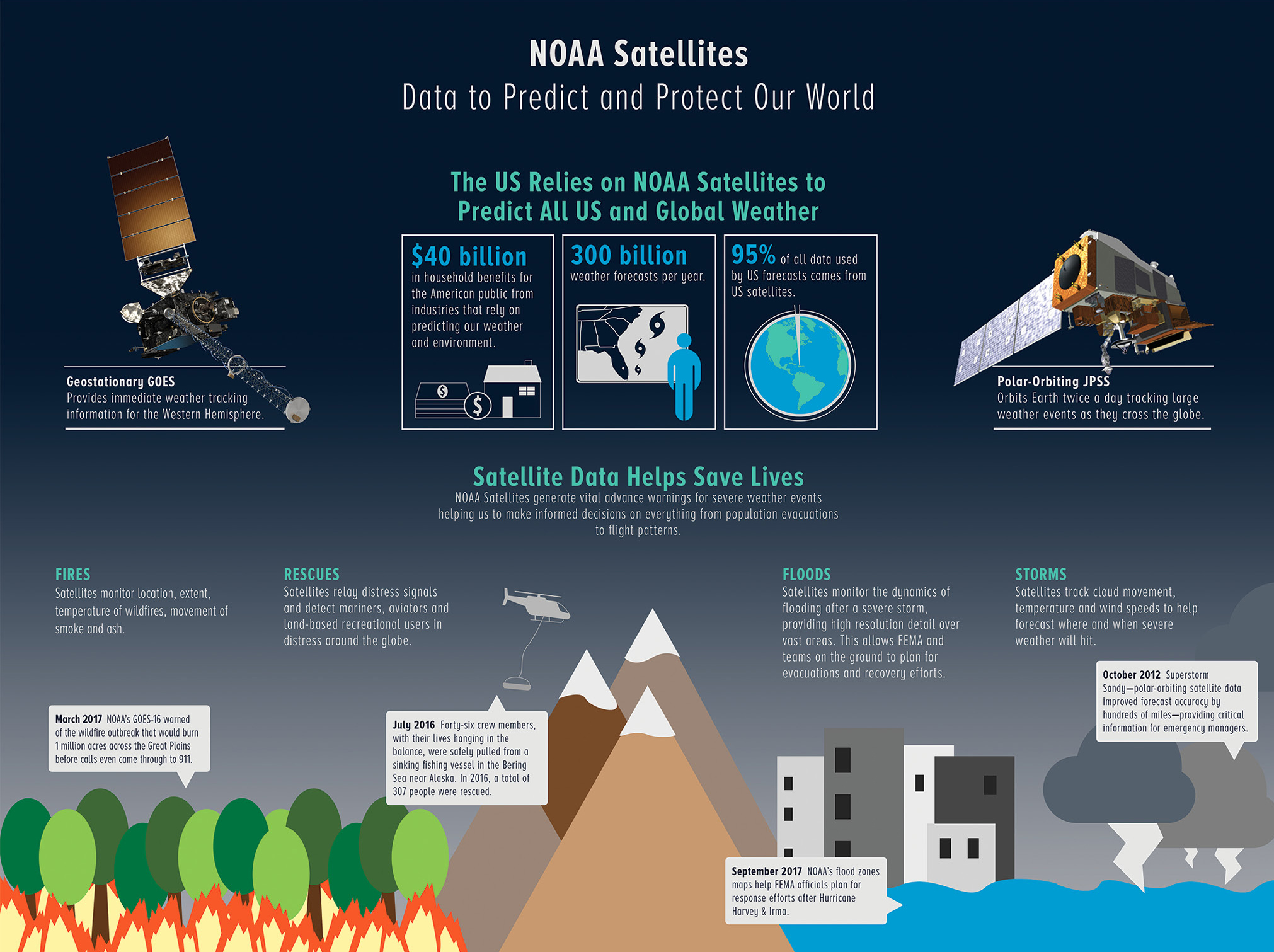
NOAA Infographic.
Visible Planets
Sky Calendar
Resources
60 Years of Looking at Earth from Above—www.earthobservatory.nasa.gov/blogs/eokids/60-years-of-looking-at-earth-from-above/
A Point in Time: The Corona Story video—www.archive.org/details/gov.archives.arc.1678526
Asteroid Day—asteroidday.org/
Big Picture of Cold War: U.S. Spy Photos Go Public—www.nyti.ms/3pVMMVz
CIA Mystery Writers—https://www.cia.gov/stories/story/mystery-writers-and-other-surprising-facts-about-studies/
CIA Shuts Down Climate Research Program—www.theatlantic.com/politics/archive/2015/05/cia-shuts-down-climate-research-program/452502/
Climate Impacts of Deforestation—www.sciencedaily.com/releases/2018/01/180111115326.htm
Environment on the Intelligence Agenda—www.nro.gov/Portals/65/documents/news/press/1996/1996-06.pdf
Corona: America’s First Satellite Program—https://www.cia.gov/static/3d24f7019bf7e718fd1d2a5c57e6a646/corona.pdf
Corona: Declassified—https://www.cia.gov/stories/story/corona-declassified/
Gateway to Astronaut Photography of the Earth—https://eol.jsc.nasa.gov
Declassified Spy Camera Development—www.nro.gov/Portals/65/documents/foia/docs/HOSR/SC-2017-00006l.pdf
Inside the C.I.A., She Became a Spy for Planet Earth—nyti.ms/397UogW
Landsat Program—https://landsat.gsfc.nasa.gov/
NASA Global Prediction, Monitoring, and Response—www.nasa.gov/centers/ames/greenspace/monitoring.html
NASA-SPoRT—www.nasa.gov/topics/earth/features/sport.html
National Astronauts Day—www.nationalastronautday.uniphigood.com/
National Space Day—www.nationaldaycalendar.com/national-space-day-first-friday-in-may/
NOAA: Explore the Earth in Real-Time—https://www.nesdis.noaa.gov/content/imagery-data-0
NOAA: Global Data Viewer—www.nnvl.noaa.gov/view/globaldata.html#NDVI
NRO: Declassified images—https://bit.ly/39rlQqN
PEON Fanzine—www.currentsky.com/peon/
Spy Satellite Photos May Aid in Global Environment Study—https://nyti.ms/3ryIuUb
Star Wars Day—www.starwars.com/star-wars-day
Total Lunar Eclipse—www.moonblink.info/Eclipse/eclipse/2021_05_26
Total Solar Eclipse—www.moonblink.info/Eclipse/eclipse/2021_06_10
Towel Day—www.towelday.org/
World Ocean Day—www.unworldoceansday.org/
Bob Riddle (bob-riddle@currentsky.com) is a science educator in Lee’s Summit, Missouri. Visit his astronomy website at http://currentsky.com.
Astronomy Earth & Space Science Middle School