
feature
Mapping Stakeholders
Tools to Scaffold Students in Deliberating About Environmental Controversies
CONTENT AREA Earth Science and Life Science
GRADE LEVEL 5–8
BIG IDEA/UNIT Human impacts and interdependent relationships in ecosystems
ESSENTIAL PRE-EXISTING KNOWLEDGE What people do as a society has had a major impact on Earth’s resources and environments, but people can make choices to reduce the impacts of human activities.
TIME REQUIRED Two 55-minute class periods
COST Approximately $20
Safety No safety issue
One of the driving goals of the Next Generation Science Standards (NGSS) is for all students to develop the skills and knowledge necessary to be well-informed citizens (NGSS Lead States 2013). However, scientific knowledge alone will not be enough for today’s students to solve tomorrow’s environmental issues. Students also need to develop the capacity to take civic action on sustainability challenges. Politics are key to addressing these challenges because to agree on and implement a solution, a community must negotiate different value systems and take collective action on controversial issues. Students need opportunities to learn how to engage in this process to be agentive citizens of democracy.
According to the National Environmental Education Foundation (2015), an environmentally literate person is someone who “makes informed decisions concerning the environment; is willing to act on these decisions to improve the well-being of other individuals, societies, and the global environment; and participates in civic life” (p. 11). Science teachers frequently engage students in the first element of environmental literacy (making informed decisions) because it draws on the ecological dimensions of place that they are typically comfortable with. However, at times they skim over the second and third elements (acting on these decisions and participating in civic life), as these elements move into the messy and often controversy-filled political dimensions of place. Because science is a social endeavor influenced by cultural norms and social values (McComas 2004), it is vital that students learn how to have open communication and democratic discussion about all environmental issues—even those that are socially controversial. To achieve this, we drew on strategies from social studies education to develop scaffolds for students investigating local environmental controversies. Pedagogically, we relied on both Parker’s (2003) public policy deliberation and Johnson and Johnson’s (1979) structured academic controversy models. Both models aim at helping students gain a deeper understanding of an issue by providing balancing viewpoints, considering the common good, and drawing on evidence to make informed decisions. Although this article uses examples from our work with Taiwanese students, we have also implemented these scaffolds in the United States.
A stakeholder approach to environmental controversies
Our work with students and environmental controversies emphasizes a stakeholder approach to decision-making and civic action. This approach encourages students to analyze stakeholders’ viewpoints based on a deliberative framework that integrates the social, economic, and environmental/ecological concerns of a community (see Figure 1). We ground this framework in the central question, “What is important to this community?” This question focuses students’ decision-making not on who is right and wrong about an issue, but on how people can live together in their community. This approach also encourages students to analyze stakeholders’ viewpoints along the three pillars of sustainability: society, economy, and the environment (Purvis, Mao, and Robinson 2019). These pillars support students in mapping the interconnected elements of an environmental controversy, approaching an issue from a systems-level perspective, and using a local lens to make sense of global phenomenon.
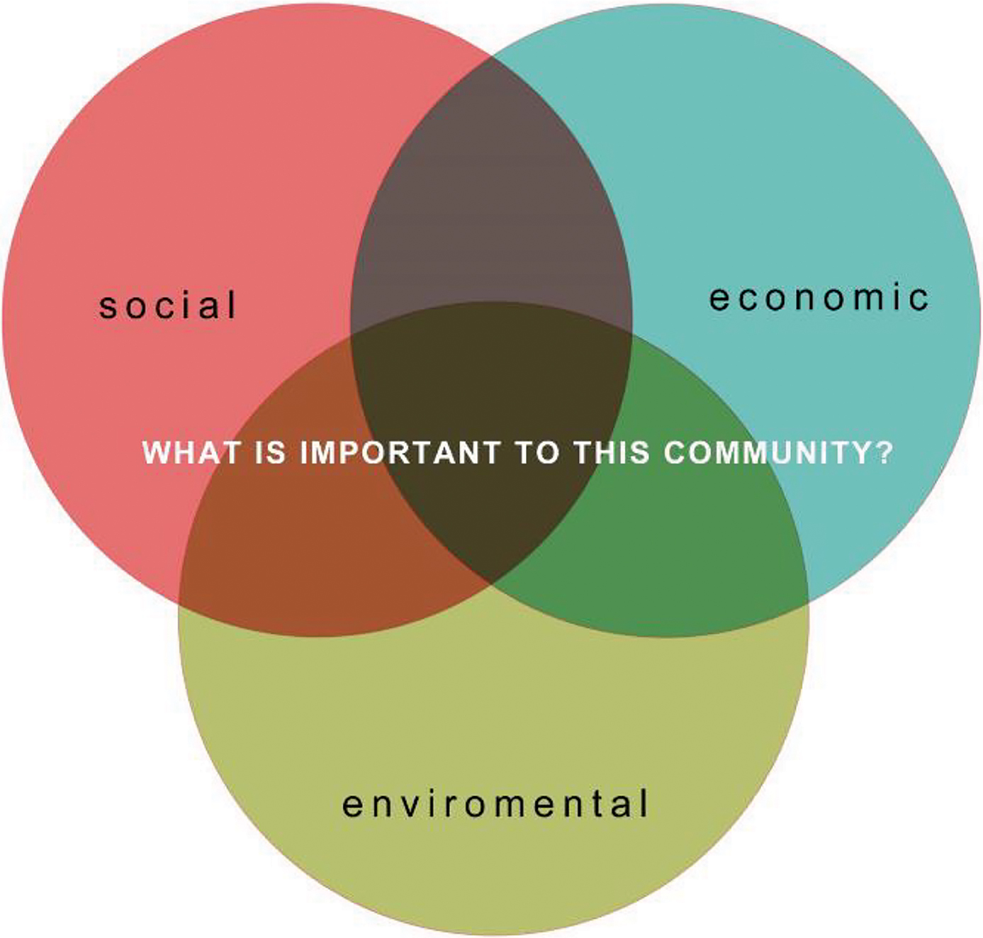
Deliberative framework
In Taiwan, we used this stakeholder approach and deliberative framework to engage students in considering whether the Changhua coastal wetland should be designated as a national wetland (see Figure 2). This question has become a highly contested controversial public policy issue, particularly for the Dacheng community. Local stakeholder groups have vastly different expectations for how to best use the wetlands. Fish farmers draw on the resources of the wetlands for their livelihood; industrial companies are working to develop new petrochemical projects in the area; and grass-roots, nongovernment organizations are pushing for laws that would protect the wetland and its endangered species through limited use. The tensions between these stakeholders have led to tremendous polarization in the community. In Dacheng, because of cultural norms to avoid conflict, the question of what to do with the wetlands became a taboo that was not to be discussed. Here in the United States, environmental controversies are often similarly avoided in educational settings because districts and teachers self-censor the curriculum to avoid addressing the challenging socio-political issues in science classes.
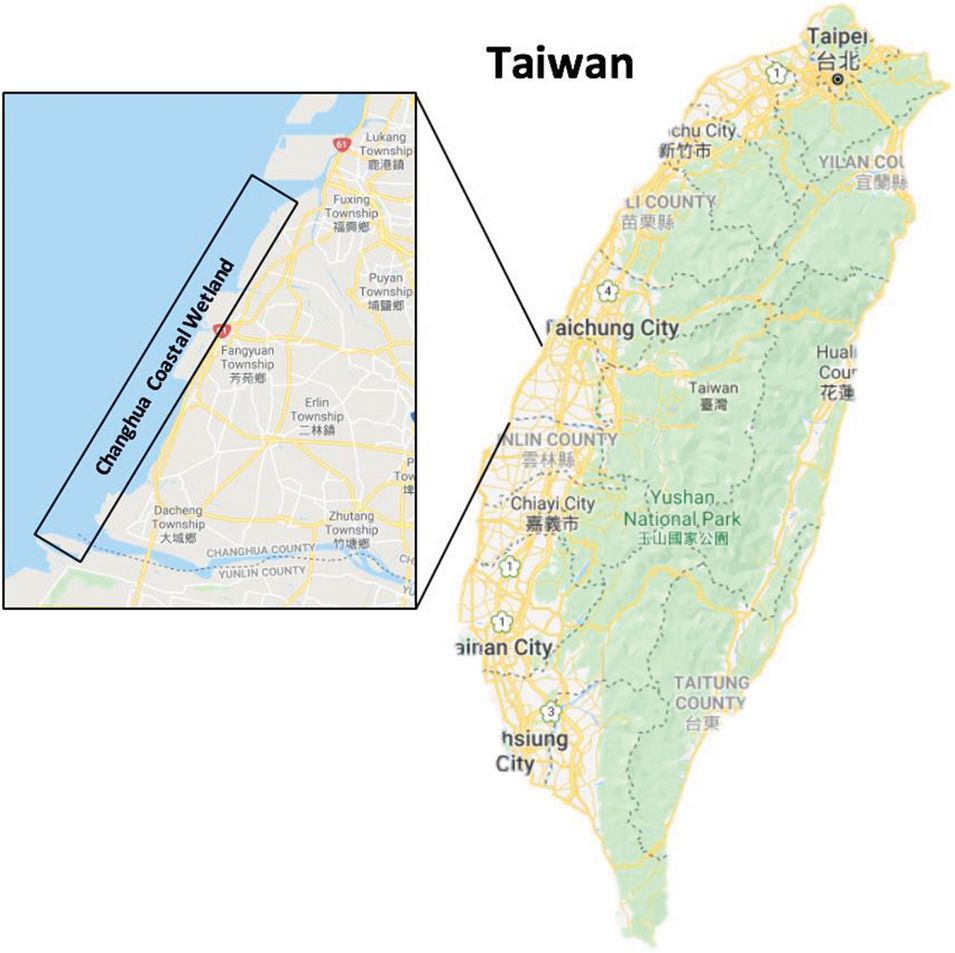
The Changhua coastal wetland
This article describes practical tools that we have used to combat this silence and support students in using democratic deliberation to reason about environmental controversies. We first piloted these teaching tools with seventh- and eighth-grade Taiwanese students as they deliberated about what to do with the Changhua coastal wetland, and we are now using them with teachers and students in Texas to support deliberation around building a pipeline across a vital aquifer recharge zone.
An environmental controversy unit: The Changhua coastal wetland
The Changhua coastal wetland unit was divided into four phases (see overview and assessment rubric in Online Supplemental Materials). The first phase, Deliberation in Democracy, focused on community-building in the classroom and modeling democratic discussion. Students shared information about the issues important to their local community, engaged in a structured academic controversy (Khourey-Bowers 2006) discussion about school uniforms, and participated in civic action by presenting their ideas to the director of student affairs. For students who are new to democratic deliberation, it can be useful to post a graphic of the deliberative framework (see Figure 1) as an anchor chart to introduce the focal question and three pillars of sustainability. In the second phase, Exploration of Issues, we introduced the specific environmental controversy of the Changhua coastal wetland. We had preselected this controversy to align with specific learning goals. Students learned about the ecology of the wetland and the viewpoints of various local stakeholders. The third phase, Development and Analysis of Policy Alternatives, focused on analyzing these diverse perspectives and making an informed decision. As part of this phase, students engaged in a mapping stakeholders learning activity in which they created their own conceptual maps of the wetland controversy. This learning activity was fundamental in expanding students’ initial views of the wetland and in supporting democratic deliberation rather than antagonistic debate in the classroom. In the fourth and final phase of the unit, Civic Action, students shared thoughts about their learning process and presented their recommendations about the wetland at a community meeting attended by many local stakeholders. As the mapping stakeholders learning activity was vital to student learning across the unit, the rest of the article focuses on detailing the structure of this activity and practical tools to implement it in middle level classrooms. The mapping stakeholders activity promotes student development across many common core standards (see Callout Box at end of article).
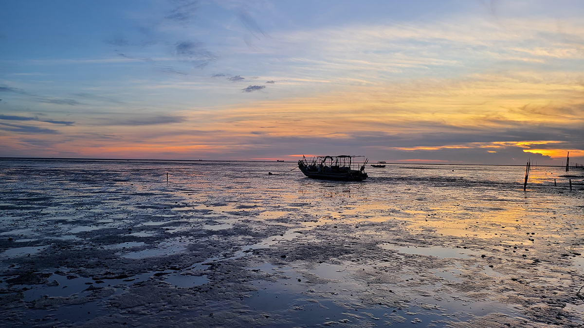
Changhua coastal wetland
Mapping stakeholders Step 1: Identify the stakeholders and their positions
The mapping stakeholders learning activity supports students in analyzing the consequences and trade-offs of policy alternatives by considering the three pillars of sustainability (society, economics, and environment) as well as taking community values into account. The stakeholders in most environmental controversies typically fall into four main groups: local residents, different levels of government, advocates for the environment such as environmental NGOs, and advocates for economic growth such as businesses. Teachers can use these four categories to help students brainstorm the stakeholders involved in their own targeted issues.
In this task, students worked in small groups (four to five students) to create a conceptual map of the wetland controversy. On the basis of the deliberative framework, students were asked to map all of the stakeholders’ positions and arguments, consider the consequences and tradeoffs of the wetland designation for each stakeholder, and propose possible solutions to the controversy. Earlier in the unit, students learned about the different stakeholders and their viewpoints about the wetland designation. We provided multiple course materials, including written texts transformed from stakeholders’ interviews, videos of press conferences and public hearings, and governmental documents (e.g., laws about wetland conservations, local residents’ concerns about wetland designation). Stakeholders were also invited to our class to address their positions to the students, providing opportunities for students to learn how to ask authentic questions and interact with adults. In addition, we designed field trips for students and residents to learn how the locals balance ecotourism and conservation at nearby wetland areas. As a class, students worked to recall these stakeholders and wrote their names on the board. For the wetland controversy, these stakeholders included the township leader, township representatives, county government, county representatives, village leaders, various environmental NGOs, ecological researchers, Dacheng residents, Fangyuan residents, and local oyster farmers. Students then filled in a general worksheet (Figure 3), organizing each stakeholder’s arguments and concerns according to the three dimensions of the deliberative framework (social, economic, and environmental).
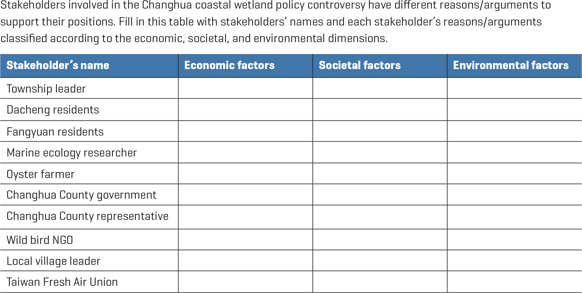
Stakeholder perspectives worksheet
Stakeholders involved in the Changhua coastal wetland policy controversy have different reasons/arguments to support their positions. Fill in this table with stakeholders’ names and each stakeholder’s reasons/arguments classified according to the economic, societal, and environmental dimensions.
Mapping stakeholders Step 2: Decide rationale for mapping
After identifying the stakeholders, students decided on the rationale and organizational structure of their maps. Map here refers to a visual demonstration of the different relationships of stakeholders that students would need to map out. We gave students prompts such us “you can use signals, lines, and sticky notes of different colors to classify different stakeholder groups’ positions and arguments.” We encouraged students to create their mapping approach by (a) considering the stakeholders’ arguments and concerns on the basis of the dimensions of the deliberative framework and (b) classifying the stakeholders’ positions about the wetland designation with colors, symbols, or other indicators. Students were provided with a blank poster, colored sticky notes, and colored markers. Aside from these instructions and common tools, each small group developed their own designs for their conceptual maps. Because this activity takes a multimodal collaborative approach, it can be particularly effective in scaffolding the learning of emergent bilingual students and students who struggle with text-only learning.
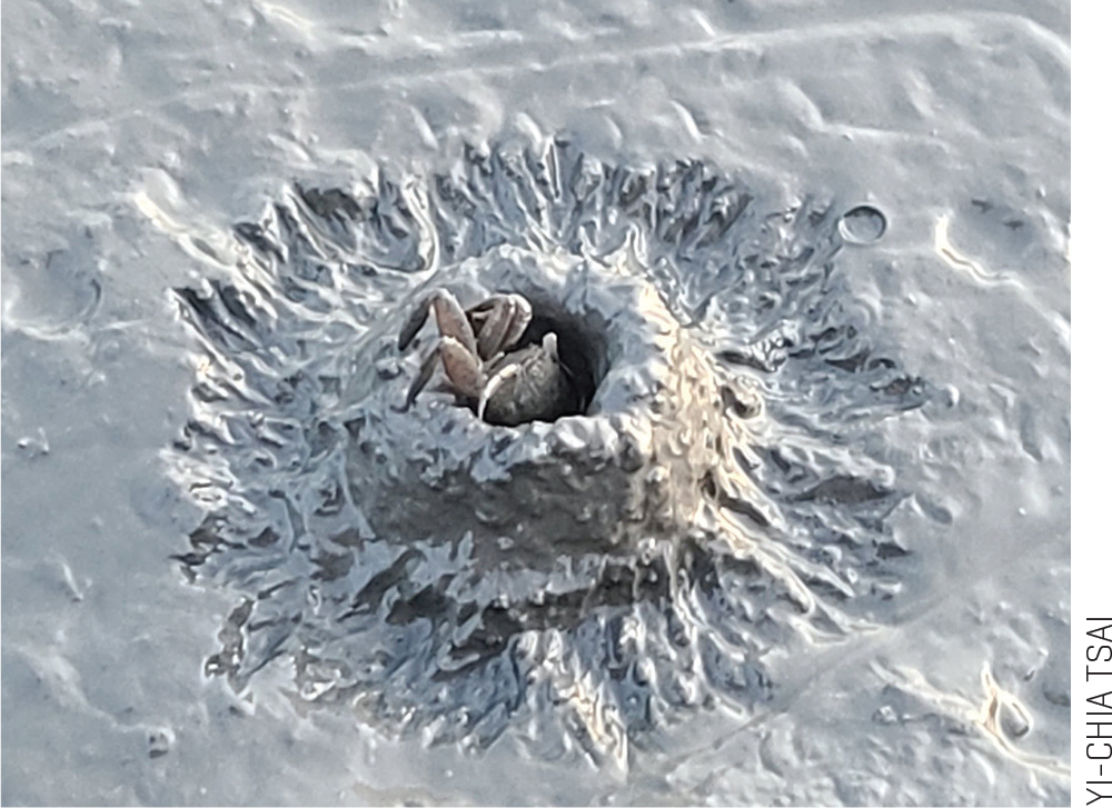
Mud crab in Changhua coastal wetland
To encourage equitable discussions in small-group work, we asked the students to ensure that all of the stakeholders’ positions and arguments that they wrote on their map were agreed on by every member. As small groups added to their maps, we asked, “Do you all agree with this statement?” If there were disagreements within a group, we asked them to explain which part(s) of the statement they agreed with and which they disagreed with and what evidence from the stakeholders supported their claim. These questions helped students refine their arguments. For example, when a group had different viewpoints about the county government’s position in the wetland controversy, we used these questions to help the students openly discuss the different evidence that they were using and deliberate about which evidence was more convincing in establishing the county government’s position.

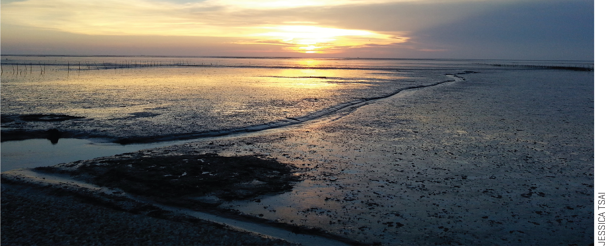
Changhua coastal wetland (photo by Yi-Chia Tsai)
As shown in Figure 4, the group that designed Map A used sticky notes of different colors to classify arguments according to the dimensions of the deliberative framework: yellow notes for economic factors, blue for environmental factors, and pink for social factors. Then on the sticky notes, the group wrote “O” if the stakeholder approved the national wetland designation, “X” if the stakeholder disapproved, and “∆“ if students were unsure of the stakeholder’s position. In contrast, Map B (see Figure 5) shows how a second small group used colored lines to classify the stakeholders’ arguments according to the dimensions of the deliberative framework and the different colored sticky notes to draw attention to the stakeholders’ position about the wetland designation.
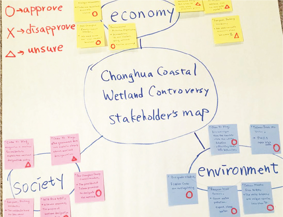
Small group Map A
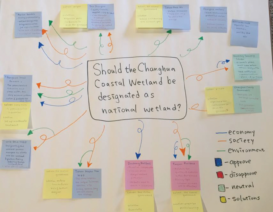
Small group Map B (with solutions)
Each small-group approach to mapping allowed students to highlight different relationships between the stakeholders, dimensions of the deliberative framework, and positions about the wetland designation. For example, Map A illustrates how stakeholders who were concerned about environmental factors (blue sticky notes) were all in favor (“O” marking) of the national wetland designation. We consider it to be instructionally important to allow students to develop their own organizational system and rationale for mapping rather than providing students with a predetermined template to fill in. By creating their own maps, students have a richer opportunity to develop and apply systems-level thinking. In addition, the diversity of maps generated by the different groups allows students to learn from each other and practice seeing a controversy from a different point of view.
Mapping stakeholders Step 3: Identify stakeholders’ concerns and generate potential solutions
After creating their maps, each small group deliberated about the tradeoffs of the national wetland designation and developed potential solutions to the environmental controversy. Students examined each stakeholder’s concerns, tried to generate potential resolutions, and identified which stakeholder was responsible for enacting solutions. During the process, we walked around to each group and asked probing questions to help students clarify their thoughts and challenge the practicability of their solutions. These questions included: “Who should be in charge of this solution?”; “What specific action should that stakeholder take?”; “What laws might be needed to regulate wetland usage?”; “How feasible is this plan—environmentally, economically, and/or socially—for the community?”; and “What short-term and long-term impacts would this solution have for each stakeholder?” For most students, this step was the most difficult part of the mapping activity as they struggled at times to come up with detailed and concrete solutions. However, this struggle was productive as it challenged them to apply their understanding and explanations of the wetland to real social conditions. After developing their solutions, students added them to their stakeholder maps.

Oysters in Changhua coastal wetland
As an example, the small group that created Map A recognized that local oyster farmers were concerned that if the Changhua coastal wetland were designated a national wetland, they would not be able to raise oysters there anymore. These students developed a solution whereby the fertile wetland area would be divided into nine smaller areas, illustrated on their map with a # sign (see Figure 6). Instead of raising oysters constantly in the same area, farmers would be given specific areas each season to raise their oysters. Decisions about which areas to use for farming and which areas to designate as off limits would be determined by scientific surveys of the ongoing resilience of the wetland. This small group’s solution effectively integrated key concepts (wise use of the wetland and sustainable development) in Taiwanese laws about wetland conservation while simultaneously addressing the economic needs of local residents.
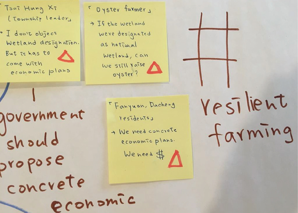
Map A with solutions for oyster farmers’ concerns and possible solutions
Mapping stakeholders Step 4: Small group presentations to the class
After completing their maps and developing potential solutions, each small group presented their work to the rest of the class. Each presentation lasted approximately 10 minutes. Presentations allow students to continue to extend their learning based on the work of their classmates. For example, the solutions developed by the group that created Map B emphasized people’s agency and recommended actions such as holding public hearings to empower local residents and organizing a press conference to push the government to act on the wetland designation. As these same elements were not always initially considered by every small group, the student presentations created another means by which students could wrestle with the overlapping political and environmental complexities inherent in sustainability challenges.
After completing the mapping stakeholders learning activity, students completed the rest of the wetland unit. They held a class Town Hall Meeting in which they role-played the different stakeholders in the wetland controversy, formulated their final conclusions about the wetland policy, and organized a community meeting where they presented their decisions to local stakeholders. This civic action by the students created a lasting impact in their community by initiating the first democratic discussion among adult stakeholders after five years of silence.
Conclusion
To effectively prepare students to be agentive citizens of democracy, science classes must grapple with the socio-political dimensions of environmental controversies as well as the ecological/environmental dimensions. However, it can be difficult to integrate these dimensions in a middle-level classroom in ways that challenge students’ initial ideas about environmental issues and support them in addressing the complexities of civic action without political bias. The mapping stakeholders learning activity encourages students to approach environmental issues through a deliberative model that values the diverse perspectives within a community. For schools that follow the 5E model for their science lessons, students could be introduced to the focal environmental controversy during the Engage phase, examine related scientific processes and principles through investigations during the Explore phase, and then implement the learning activities described in this article as part of the Explain and/or Elaborate phase. Whether the environmental controversy is about designating a protected area, building a pipeline, reintroducing wolves, or removing a dam, a stakeholder approach to decision-making and civic action can support students in developing pragmatic community-based solutions to sustainability challenges.
Yun-Wen Chan (ywchan@txstate.edu) is an assistant professor of social studies education and Michelle Forsythe is an assistant professor of STEM education, both in the Department of Curriculum and Instruction at Texas State University in San Marcos.
Earth & Space Science Environmental Science Life Science Pedagogy Teaching Strategies Middle School