
feature
Where Are the Volcanoes?
A Socioscientific Hunt for Volcanoes Through the Recognition of Patterns in Earth Science
CONTENT AREA Earth Science
GRADE LEVEL 6–8
BIG IDEA/UNIT Plate tectonics
ESSENTIAL PRE-EXISTING KNOWLEDGE The locations of volcanoes occur in patterns; most volcanoes occur in bands that are often along the boundaries between continents and oceans.
TIME REQUIRED Two 55-minute class periods
COST None
SAFETY None
Middle school students want to understand how the world around them works and are curious about large-scale disasters. Teachers can capitalize on this curiosity by allowing students to develop an understanding of patterns of volcanic activity and making space for them to recognize connections with sociogeographic issues that result from geologic phenomena. Exploring regions where active volcanoes are found provides an inquiry-based opportunity for students to explore content objectives through modeling, data analysis, and identifying and using patterns to understand geologic events. In this investigation, students engage in numerous science and engineering practices, and multiple crosscutting concepts—including patterns and systems modeling—are addressed.
As students begin to understand the patterns of volcano locations, the implications of living near an active volcano, as well as the deep ties between volcanoes and the cultures of those living nearby, become apparent. Authentic investigation that includes making predictions about the locations of potentially active volcanoes and empathizing with those who might be affected by future eruptions requires students to connect with science and engineering practices while making moral and ethical judgments as they engage in dialogue based on research. The use of socioscientific issues (SSIs) as contexts for learning adds relevance and applicability to the concepts and practices being mastered as students employ them to inform and protect vulnerable populations (Zeidler and Nichols 2009).
Cross-curricular instruction, such as the inclusion of social studies and mathematics, is generally required to effectively understand and respond to SSIs. For example, the ability to predict where volcanoes will form and erupt and to determine whether and how close people should live near volcanoes requires students to employ systems thinking while integrating their scientific and ethical reasoning with mapping. Instructional approaches that integrate science, math, and social studies in the context of relevant contemporary issues that have a moral component are considered best practices for teaching middle school science and are expected to enhance student performance and contribute to functional scientific literacy (Oliveira et al. 2013; Reed and Groth 2009; Zeidler 2016).
In this investigation, students engage with science, mathematics, and social studies concepts and practices to inform their perspectives as they map ancient landforms and analyze data to identify patterns that will begin to elucidate the movement of Earth’s plates. In doing so, students will participate in a mapping activity to develop a pattern-based understanding of volcanoes based on locations they model on a world map. As students revise their predictions of potential future volcano sites based on their analysis of modeled data, the order and consistency in natural systems allow them to have growing confidence in their predictions. This investigation will empower students, as global problem solvers, to identify the patterns in systems (plate tectonics and volcanoes) and use that knowledge to support populations that live in areas prone to natural disasters.
Conducting the investigation
To begin class, engage students by asking what they know about volcanoes. You may have some students share experiences with volcanoes they have lived near or visited. As students share, record their observations about the volcanoes on the board to refer back to as the investigation progresses. Then, capture students’ interest with the short National Geographic video of volcanoes erupting and the resulting destruction (see link in Online Resources). This video has a great “wow” factor to get students asking questions and thinking about the importance of understanding volcanoes while providing an opportunity for students to begin making connections between the geologic aspects of volcanoes and the social ramifications of living near them. Students may begin asking questions such as, “Where is the biggest volcano in the world?”, “How hot is lava if it can melt a car?”, and “Why would anyone live near a volcano?” Record these questions on the board to refer back to as the discussion and exploration continue.
Ask students if they think that volcanoes are currently active and what it means for volcanoes to be active. Explain that scientists continually collect data on the activity of volcanoes and that we are going to use their data to serve as the basis for evidence to answer our questions. Place students into groups of three. Each group should have a device that can access the internet and the volcanoes worksheets (see Supplemental Materials), as well as pencils or colored pencils. Have them create a hypothesis about the potential location a future volcano could form based on their prior knowledge and the information their classmates have shared. Have the students in each group collaboratively decide on the potential location where a volcano could be found and place the number “1” (representing their initial prediction) on this location on the world map, then write a brief justification for their prediction. This placement may be almost entirely random for some students, and others might have prior knowledge that enables them to frame their hypothesis on scientific principles associated with tectonic plate movement at plate boundaries.
Assign group members the following roles: mapmaker (the student who will map the volcano locations and map the group prediction), technology manager (the student who will manage the use of the USGS website), and recorder (the student who will record group observations and record the names and locations of mapped volcanoes). Direct student groups to the USGS Weekly Volcano Activity Report (Smithsonian Institute 2013), which is a resource that is updated weekly and provides information about volcanoes that are currently active. As this resource is continually updated, the volcanoes that are reported will change, but the patterns resulting from student’ plotted data will remain similar given the consistency in the locations of volcanoes. In small groups, students will work through the list of volcanoes on the website by helping the mapmaker map two volcanoes on the list, identifying any characteristics of the locations that the newly mapped volcanoes may have in common, and then working together to refine their predictions of the location where a volcano may form in the future based on the commonalities in location characteristics shared by the mapped volcanoes. As groups refine their predictions based on new data mapped, the mapmaker will place the number of each new prediction (2, 3, 4, and 5) on the map to show changes in their thinking as they progress through the activity (see Figure 1). Allow students to alternate between mapping two volcanoes and refining their prediction for 10 to 15 minutes. Gather observations from students as they work and record those on the board to drive further discussion. These observations may include: “I don’t think there are volcanoes in Australia’’ and “Most of the volcanoes are on the edges of continents.” They may also develop more questions such as: “Are most volcanoes underwater?” and “Are there more volcanoes on one side of the equator than the other?”
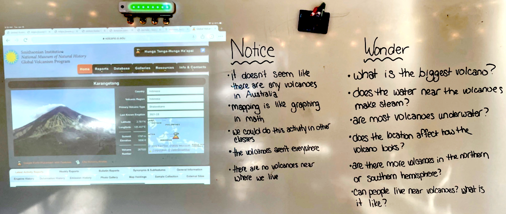
Projection of information and record of students’ questions and observations.
After students make their final prediction, ask each group to reflect on how they used the scientific practice of analyzing data and the crosscutting concept of patterns to make their predictions. Have each group share with the class what patterns they were able to identify and how the order and consistency they observed in the volcano locations allowed them to continue to refine their predictions. Then ask students about the relationship among the locations of the volcanoes. Although tectonic plate movement is a complex topic, this activity provides an opportunity to briefly introduce the concept of tectonic plates and their movement along convergent boundaries, which sometimes results in the creation of volcanoes. Connecting the patterns students observe regarding volcano location with the location of plate boundaries introduces the importance of understanding tectonic plate movement, a concept they will more deeply consider in their future studies.
Ask students to discuss with their group whether they think there is a single method of organizing data, or if data can be organized in different ways to improve understanding. Allow groups to discuss for one to two minutes, then share their thoughts. Distribute a Pacific-centered world map to each group (Braile and Braile 2001), and have the groups remap the volcanoes and their predictions to make comparisons in the representation of the data (to compare the data plotted on the Atlantic and Pacific-centered maps, see Figure 2). Then ask the groups to evaluate which map they feel would be best suited for visualizing the data to identify patterns and draw conclusions about where volcanoes are expected to be located. Students should recognize that when the data set is shifted from the more common Atlantic-centered map to a Pacific-centered map, the pattern of volcano locations centered around the Ring of Fire is more prominently displayed. Point out to students that reorganizing data with a different focal point is a common practice that scientists employ to provide new insights and facilitate discovery.
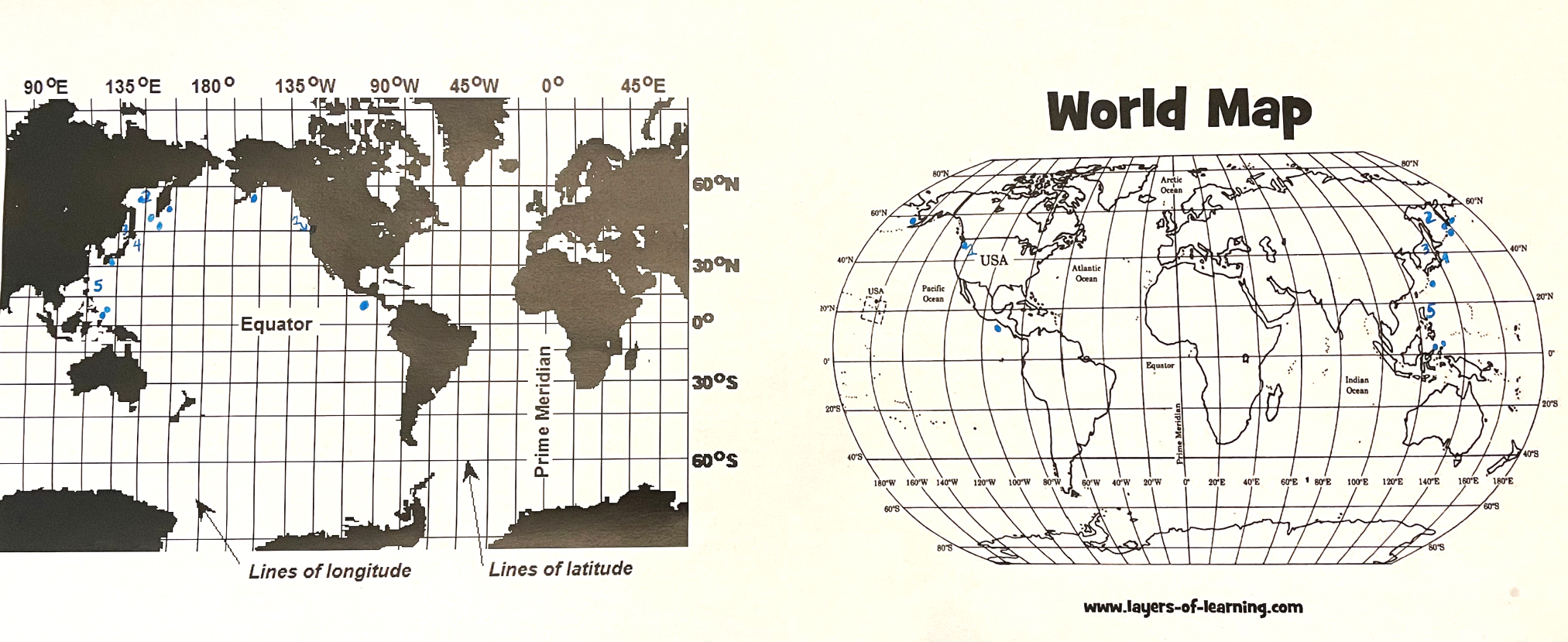
Sample completed maps for comparison with volcano locations and predictions.
Explain that there are many more volcanoes that scientists are currently monitoring and that it would be interesting to see if these volcanoes’ locations seem to follow the same patterns the class has identified. Display the USGS Volcano Hazard Map (U.S. Geological Survey n.d.), which maps a significantly greater number of active and potentially active volcanoes than students previously were able to see on the USGS Weekly Volcano Activity Report. Using this large, modeled set of data that is already mapped, have students make a final prediction of where a future volcano may form.
To wrap up the first-class period of this investigation, reinforce the connection between active volcanoes and their tendency to be located in bands, often at the edges of continents. This provides a bridge to the understanding of the disciplinary core idea that connects the theory of plate tectonics to the concept of plate boundaries being a primary location of geologic events. As students should have developed an understanding that there is a pattern to the location of volcanoes in fourth grade, this activity allows this pattern to be correlated primarily to plate boundaries. Teachers should draw attention to the patterns students identified and explain that scientists have identified these patterns in volcano locations and use them to establish boundaries between the pieces of Earth’s crust. As students make predictions based on the locations of volcanoes, their engagement in scientific practices by developing and using models and the analysis and interpretation of data is enabled by the assumption that a future volcano would most likely be located where past volcanoes have been formed.
Scientific evaluation
The primary scientific objective to evaluate at this point is students’ understanding of the patterns in the locations of volcanoes, which often occur in bands that can be quickly identified and used to locate active convergent and divergent plate boundaries. It is also important to correlate this understanding to the student’s ability to use the science practice of engaging in argument using the claim-evidence-reasoning framework (McNeill and Martin 2011). Provide students the opportunity to demonstrate these skills by having them write three sentences in which they support their claim for where previously unidentified volcanoes would most likely be found using evidence from the model created during the investigation. Evaluate students’ arguments using the guidelines on the first row of the activity rubric (see Figure 3). To evaluate students’ abilities to connect this exploration with aspects of the nature of science, have them explain how the reorganization of their data on a map with a different focus enabled them to make a scientific discovery regarding the patterns in the location of volcanoes that may not have otherwise been made using the initial map. Evaluate students’ explanations using the guidelines on the second row of the rubric.
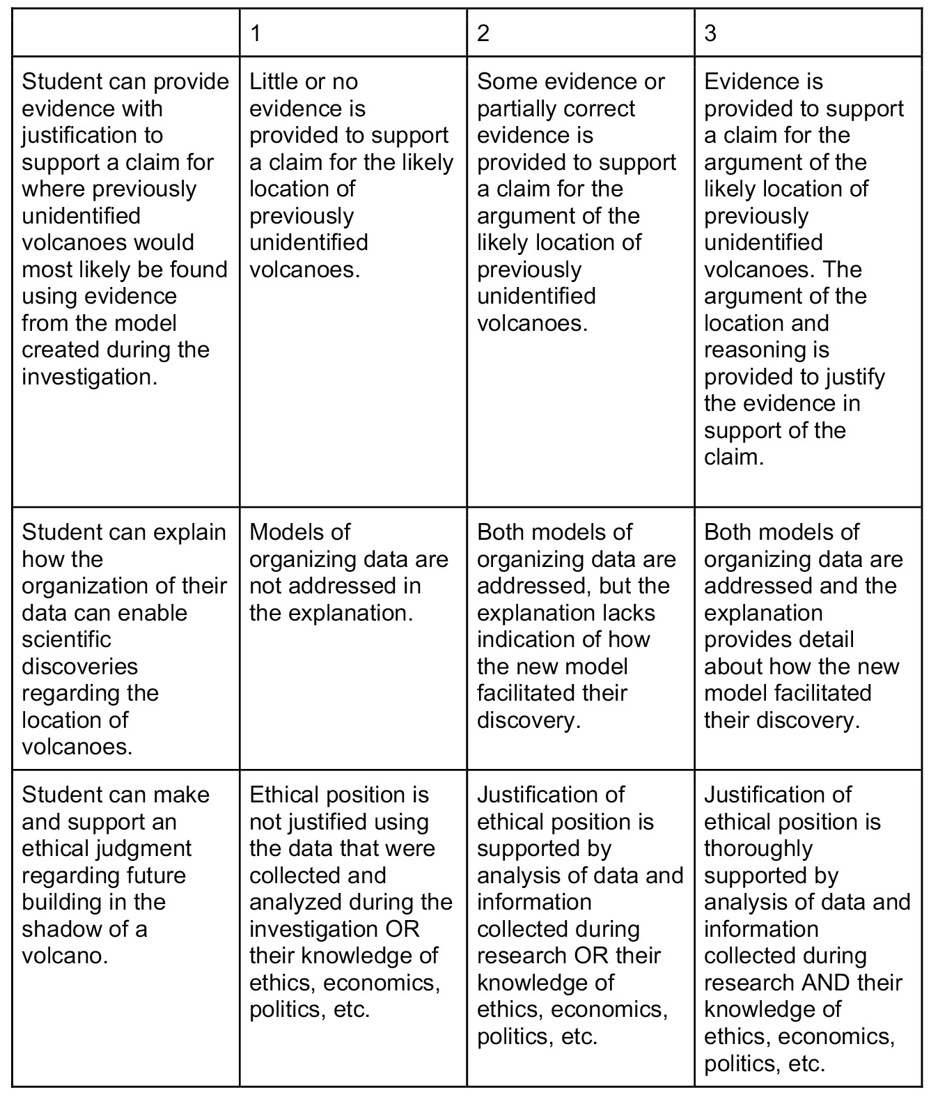
Rubric for activity.
Socioscientific exploration
To help students recognize the relevance and importance of understanding where volcanoes are located, present students with the following scenario: You are going to a summer scholarship camp and you meet a student who lives in the Philippines. When you ask the student where they live, they tell you that they live near Mt. Pinatubo, a volcano that had a massive eruption in 1991 that impacted global climate (Diggles 2005). It recently had another minor eruption. Students may initially feel that it is fascinating to run into a person who lives in the shadow of an active volcano, but in reality, 800 million people live within 100 kilometers of one of the Earth’s active volcanoes (University of Bristol 2017). Have student groups brainstorm questions they would want to ask that peer and record them on the board.
Next, challenge students to identify volcanoes in geographic regions recently studied in social studies, then investigate how living near a volcano can affect the culture of a region. Students who need additional support can be asked more direct questions such as “What is a city near an active volcano?”, “What are the main industries in this city?”, and “How is living in this city different from where I live?” Some students may benefit from being guided to specific internet search terms such as “advantages of living near a volcano” or “living in the shadow of a volcano.” Students may find that regions in close proximity to volcanoes tend to have fertile soil as a result of volcanic rock and ash, which increases crop yields for farmers (BBC 2022). Tourism brought by volcanoes also serves as a boon for local economies, and the availability of geothermal energy can also make electricity cheaper for locals. In addition, the fear that stems from living in the shadow of a volcano shapes religious culture in these regions. For example, in Indonesia, it is common practice for residents to make an offering to a volcano in exchange for protection (Hawaiian Volcano Observatory 2010). Whereas many students’ initial reactions may be to question why people would choose to live somewhere so dangerous or even urge people to move away from volcanoes, they may be surprised that the cultures and ways of life experienced by populations living in the shadows of volcanoes can be quite rich!
The ability to predict where volcanoes are likely to be active begs the question: “What should we do with this knowledge? With this in mind, pose the following to your students: Given our ability to identify locations likely to experience active volcanoes, should we restrict the construction of new residential areas in the shadow of active volcanoes? Task students with writing a one- to three-paragraph justification of their belief (modify the length to allow for differentiation). Encourage students to use various types of knowledge to support their position, including the scientific evidence that resulted from the data they plotted and analyzed as part of this investigation, as well as knowledge of ethics, economics, and politics that they may have considered in their social studies class.
Conclusion
Through this investigation, students have the opportunity to build connections between content areas and demonstrate their use of science practices and crosscutting concepts related to understanding the significance of identifying patterns in scientific exploration. In doing so, students engage in meaningful collaboration as they work to make and justify predictions about where volcanoes are located, as well as consider the ethical implications of constructing new settlements in the shadow of active volcanoes.
Online Resources
National Geographic: Volcanic Eruptions—https://bit.ly/40eylP9
Supplemental Materials
Volcanoes worksheets—https://bit.ly/3YSkuws
Kimberly Kirstein (kimberly.kirstein@ccboe.net) is an eighth-grade math teacher at Evans Middle School in Evans Georgia and a doctoral student at Georgia Southern University in Statesboro. David C. Owens is an assistant professor in the Department of Middle Grades and Secondary Education at Georgia Southern University in Statesboro.
Earth & Space Science Phenomena Middle School