
feature
Models for Developing Explanations of Earth’s Dynamic Plate System
Science Scope—March/April 2022 (Volume 45, Issue 4)
By Amy Pallant, Trudi Lord, Sarah Pryputniewicz, and Scott McDonald
CONTENT AREA Earth/Environmental Science
GRADE LEVEL 6–8
BIG IDEA/UNIT Plate tectonics explain the location of Earth’s landforms,
ESSENTIAL PRE-EXISTING KNOWLEDGE None
TIME REQUIRED Approximately 8–10 class periods (45 minutes)
COST Free Safety No special safety concerns
GEODE Technology Tools
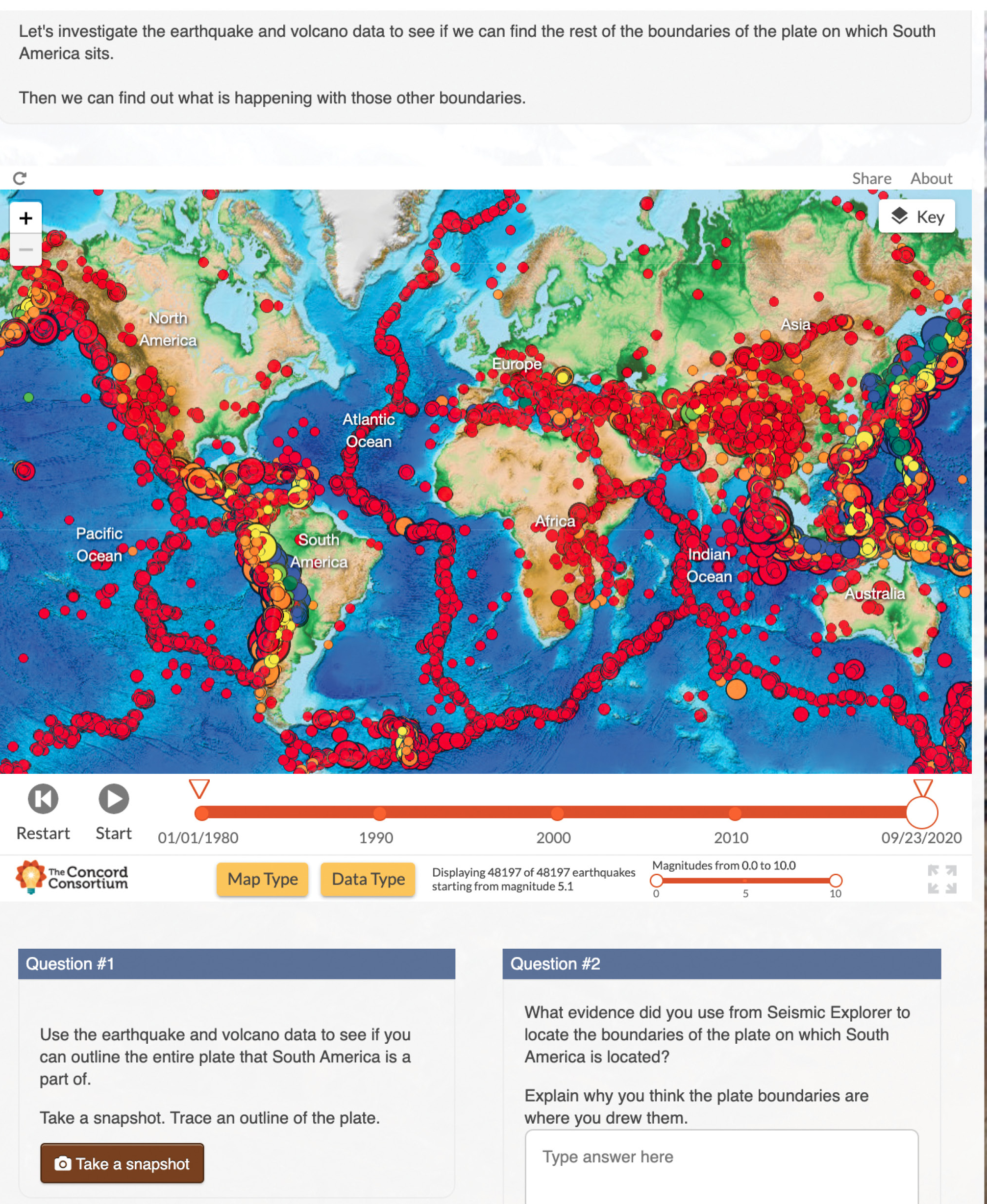
Seismic Explorer is a data visualization tool that shows real-world earthquake data from the United States Geological Survey; volcanic eruption data from the Smithsonian Institution Global Volcanism Program; and plate motion data displayed on satellite, relief, and street maps. Throughout the plate tectonics module’s five activities, students are scaffolded on ways to use Seismic Explorer to (1) investigate earthquake and volcanic eruption distribution patterns across Earth’s surface (see Figure 2a), (2) make connections between the earthquake, volcanic eruption, and landform distributions and plate boundaries, and (3) use cross-sections to investigate earthquake depth patterns (see Figure 2b).
Tectonic Explorer is a dynamic computer model of a plate system on a fictional Earth-like planet (see Figure 3). The computational model that drives Tectonic Explorer is based on a physics engine that calculates forces and torques, as well as accelerations and interactions between plates. While the model was designed to be accessible to students, it was informed by current scientific understandings of plate properties found on Earth, including thermodynamic laws governing plate motion and behavior. Tectonic Explorer enables students to simulate multiple plate system scenarios and observe the different types of plate interactions responsible for patterns of events and landforms observed on Earth’s surface.
The Ring of Fire is the location of 75% of the world’s volcanoes and 90% of its earthquakes. They outline the Pacific Ocean and reveal the zones where tectonic plates meet, including the Eurasian, North American, Caribbean, Nazca, Antarctic, Indian, Australian, and several other plates (National Geographic 2020). In fact, the Ring of Fire is used as a key piece of evidence for the existence of tectonic plates. Students are often asked to plot earthquake epicenter data on world maps and identify the narrow zones of seismic activity along these plate boundaries (see Figure 1). This activity and parallel ones looking at patterns of volcanic eruptions are designed to support student understanding of plate tectonics, a theory that explains the structure of Earth’s crust and the associated phenomena that results from the interactions of moving plates. While engaging students with data about these events can be meaningful, this traditional approach to teaching the Ring of Fire does not include a focus on students’ reasoning about why these patterns of geologic events occur.
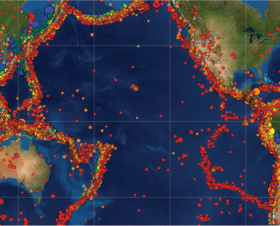
The Ring of Fire is shown in Seismic Explorer by the narrow band of volcanic eruptions (triangles) and seismic activity (circles) around the edges of the Pacific Ocean.
The power of plate tectonics lies in its ability to explain why mountains, deep-sea trenches, mid-ocean ridges, and island arcs are located where they are and why earthquakes and volcanic eruptions are found in narrow bands around the globe. Fundamental to plate tectonics is the notion that Earth’s solid outer crust is broken into plates that move all the time. In other words, Earth’s plates at the surface are the observable part of a much greater dynamic system that involves inner Earth mechanisms. As students connect plate motion, seismic activity, and landforms to the driving mechanisms in Earth’s interior, they build a more complete understanding of the plate system. Students are able to explain both how land features and seismic activities are linked to the whole plate system and why these phenomena occur. Once the dynamic system and its behaviors are understood, historical evidence such as plate geography (e.g., matching coastlines between South America and Africa) and continental drift can be explained. This approach has the potential of avoiding common misconceptions, such as thinking continents are moving and not plates, or that earthquakes cause plates to move rather than being a result of plate movement.
Understanding the mechanisms and behaviors of Earth’s plate system is difficult because the plates are continuously moving on a large three-dimensional sphere over hundreds of millions of years. Many fundamental ideas about plate tectonics are difficult to convey if teachers rely solely on static visualizations using two-dimensional maps that display current plate positions, vectors of plate motion, or seismic data recorded at the surface. The Concord Consortium and Pennsylvania State University have developed a free online plate tectonics curriculum module (PT module, hereafter; see Online Resources) as part of the National Science Foundation–funded project called Geological Models for Explorations of Dynamic Earth (GEODE).
The PT module offers a unique approach with two innovative tools that allow students to make connections between real-world data and plate tectonics models. Throughout the module’s five activities, students engage in authentic geoscientific explorations of real-world landform and seismic data patterns with the Seismic Explorer (see Figure 2A and B). They also interact with the Tectonic Explorer, a model that features an Earth-like plate system (see Figure 3). Through guided inquiry, students connect simulated phenomena and real-world phenomena. By the end of the module, they are able to explain the landforms and seismic activity caused by plate interactions and driving mechanisms found in Earth’s interior.
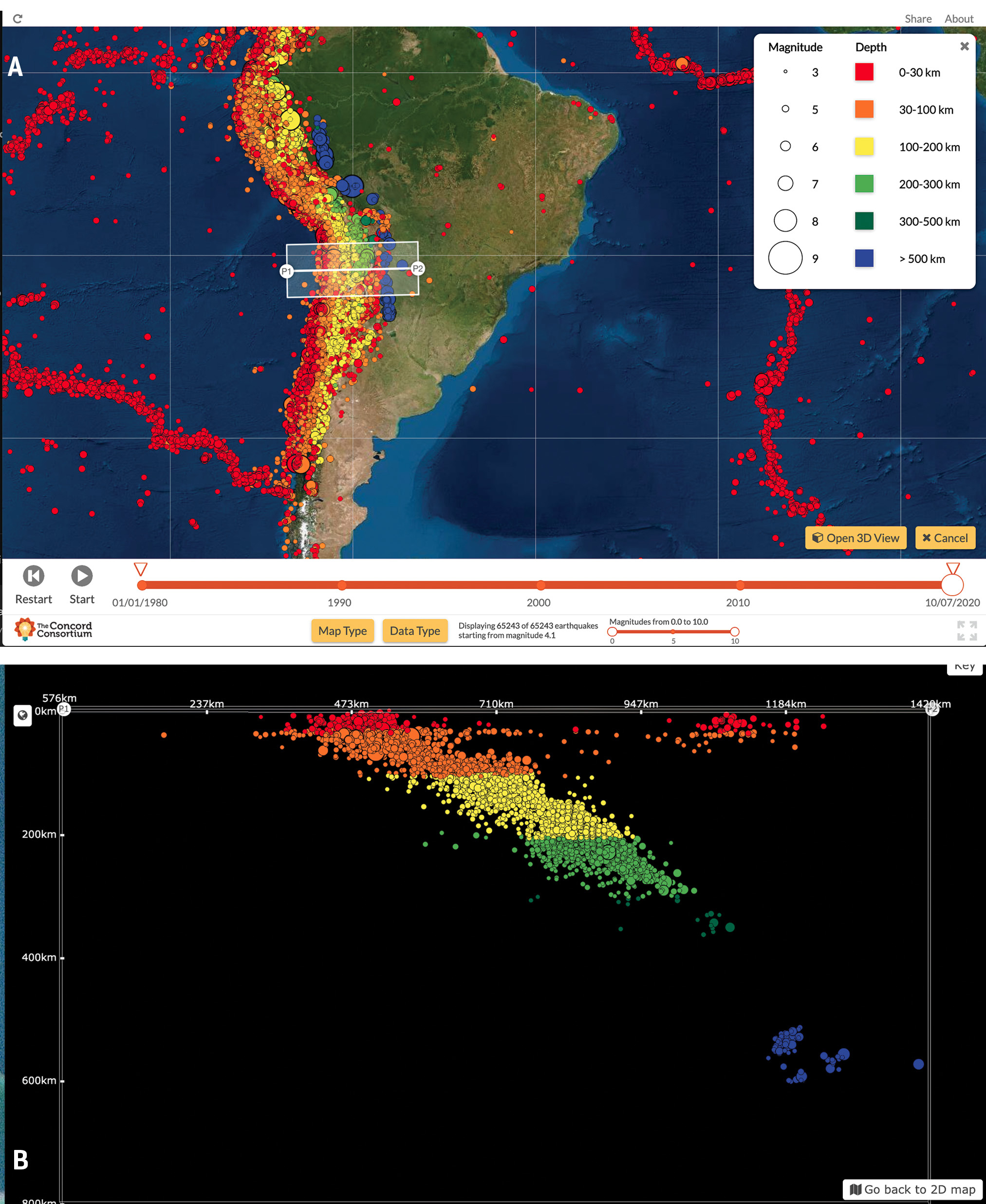
(A) earthquake pattern shown along the West Coast of South America; (B) cross-section showing the depth pattern of the earthquakes along the transect highlighted in 2A.
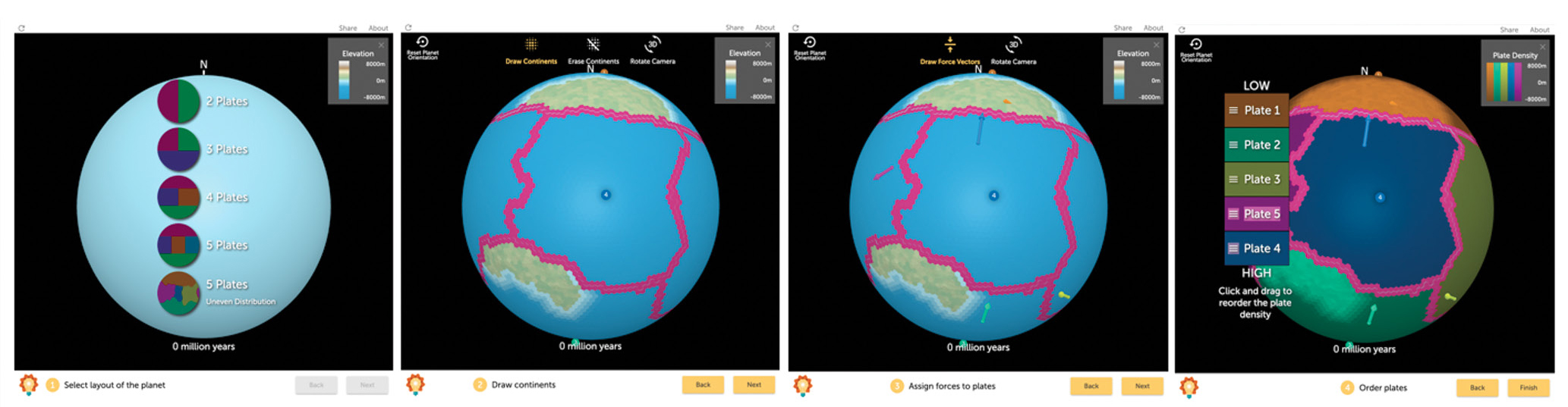
Illustration of the Tectonic Explorer planet wizard where students choose the number of plates, draw continents, assign force vectors, and choose relative density of each plate.
Constructing explanations from the plate system perspective
The PT module helps students develop robust plate system explanations based on the following understandings: (1) each of Earth’s tectonic plates is surrounded by adjacent plates and interacts with them along their shared boundaries; (2) types of plate boundaries are the result of one plate’s movement relative to an adjacent plate and result in characteristic patterns of geologic events and landforms; (3) plate movement is the result of mantle convection and gravity; and (4) over Earth’s history, the surface of the planet has changed.
Students use the two key technology tools as sources of evidence to make sense of Earth’s plate interactions (see GEODE Technology Tools in box). Seismic Explorer data illustrate earthquake, volcanic eruption, and landforms patterns. Tectonic Explorer represents a three-dimensional plate system on a fictional, Earth-like planet and allows students to set initial conditions and witness countless scenarios of dynamic changes that can take place on the planet’s surface. The PT module is aligned with the disciplinary core ideas in ESS2.B Plate Tectonics and Large-Scale System Interactions, the two science practices using models and constructing explanations, and the crosscutting concept of systems and system models specified in the Next Generation Science Standards (NGSS Lead States 2013).
Conducting authentic plate tectonics investigations in class
Each of the five activities starts with a real-world phenomenon, foregrounding exciting landforms on Earth and guiding students to develop evidence-based causal explanations from their investigations and a deep understanding of plate tectonics as a system as a result. In the first activity, students examine GPS data to develop the concept that Earth’s surface is moving. In the second activity, students explore earthquake, volcanic eruption, and landform patterns along interacting plate boundaries and connect plate motion to these patterns, then investigate multiple plate boundaries and interactions simultaneously in the third activity. In the fourth activity, students explore the causal mechanisms for plate motion, including mantle flow and gravitational forces, by watching detailed scientific animations. In the fifth activity, students put it all together and consider long-term changes on Earth’s surface, making predictions for Earth’s future.
Engage (Activity 1, 60 minutes)
The PT module opens with an iconic photograph of the Earth taken by NASA astronauts as students ponder: Has Earth always looked like this? and Will Earth continue to look like this in the future? Through a guided investigation, students explore GPS data as they look for evidence of Earth movement. They also use earthquake and volcanic eruption data displayed in Seismic Explorer to identify areas of seismic activity on Earth’s surface and discover that Earth’s surface is broken into constantly moving pieces, known as tectonic plates.
Explore and Explain (Activities 2 and 3, 180 minutes)
In the next two activities, students develop causal explanations about what is happening on Earth’s surface through a series of case studies of real landforms, such as the Andes Mountains and the Mid-Atlantic Ridge. In traditional instruction, students often study earthquakes, volcanoes, and mountain building before learning about plate tectonic theory. The PT module instead presents geologic processes and landforms through the lens of moving plates with a repeating pattern of using Seismic Explorer to observe patterns of landforms and geologic events in specific locations on Earth, considering ideas about how plate movement and interactions might explain the patterns, then testing their ideas with Tectonic Explorer.
For example, students explore the Andes Mountain Range, the longest mountain range in the world, found along the western side of South America. They investigate a profile of elevations and then earthquake and volcanic eruption patterns in Seismic Explorer and speculate about what they think is happening between the two plates to produce these patterns (see Figure 2A and B). Embedded prompts scaffold students’ interaction with Seismic Explorer as they use evidence drawn from investigations as data to develop explanations (see example in Figure 4).
A plate system reasoning task from the online plate tectonics module. Students interact with the model and respond to embedded questions in the online module.
Students then use Tectonic Explorer to model the convergent boundary near the Andes Mountains. They draw continents on modeled plates, assign force vectors to the plates, and order the density of the plates in relationship to one another (see Figure 3). They run the model and compare the outcome of their simulated planet to the real-world phenomenon, determining how their setup gives rise to the emergent phenomena they observe as the Tectonic Explorer runs (see Figure 5). Their goal is to adjust initial settings until the model resembles the real-world phenomenon. Tectonic Explorer is designed to help students gain intuition about how geologic processes lead to seismic events and landforms when two plates interact. For instance, subduction of an oceanic plate under a plate with continental crust causes volcanic eruptions, earthquakes, an ocean trench and mountains to form. Students begin to recognize similarities in landforms and events as plates converge both in the model and in the real world.
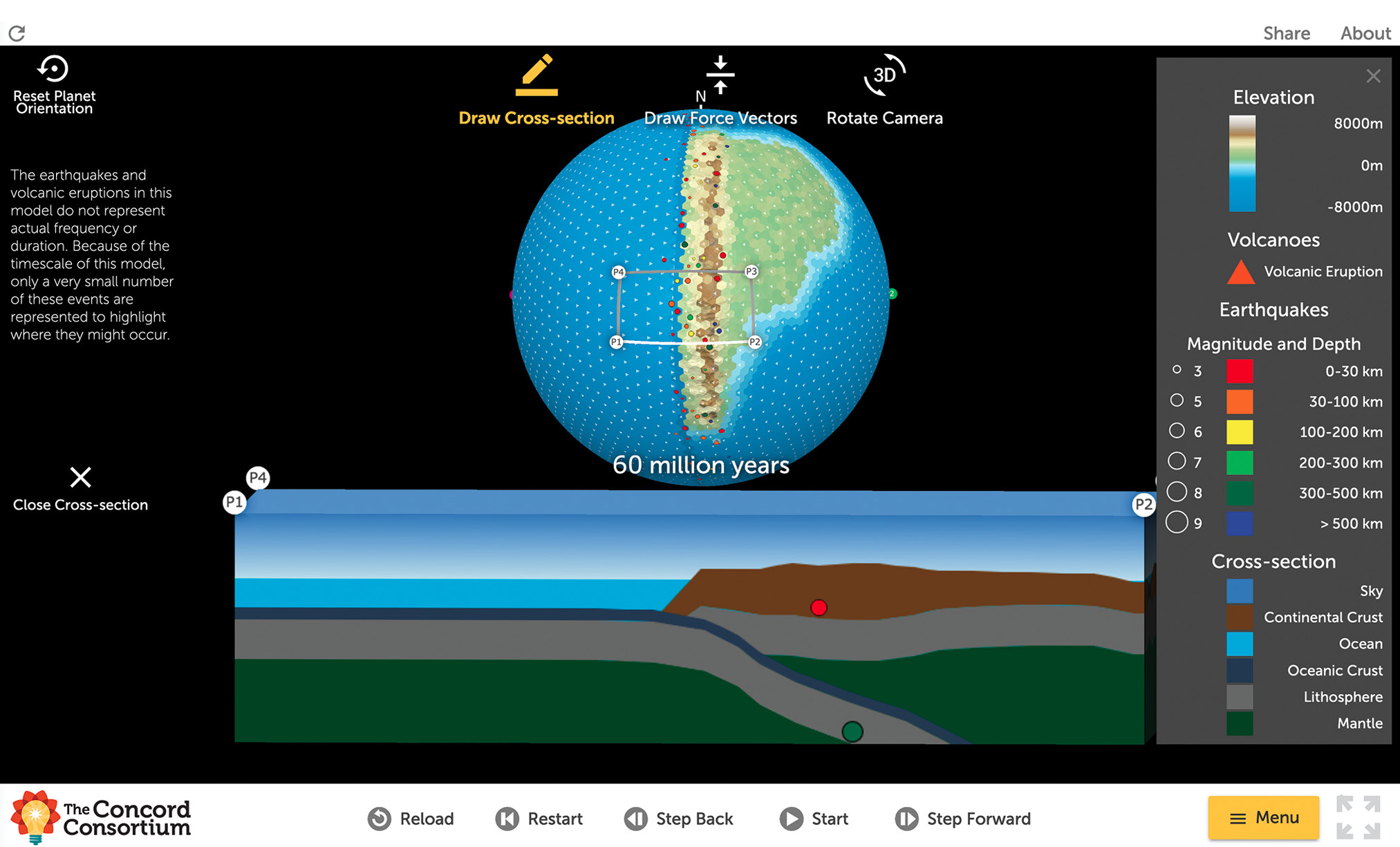
Tectonic Explorer has been set up to explore the interactions of two converging plates. As the model runs, students can observe a subducting plate and the emergent phenomena that result, such as mountain formation, volcanic eruption activity, and earthquakes.
In the third activity, they use the Tectonic Explorer again, this time to show not only the relationship between the movement along the convergent boundary near the Andes Mountains, but also the motion along the divergent boundary found on the other side of the plate in the Atlantic Ocean. While plate boundary types are typically taught independently, students are able to connect a divergent boundary on one side of a plate to the convergent boundary on the other side of the plate as they begin to understand that plates are continuously interacting along their entire border and with multiple plates at the same time.
Students traditionally have difficulty transitioning from considerations of a single boundary to reasoning about plates bounded on all sides and interacting on all sides simultaneously (McDonald et al. 2019). Tectonic Explorer allows students to rotate the Earth-like planet in three dimensions and see all the boundaries on each plate in the context of the whole plate system. As a result, students can easily observe that as a plate is subducted on one side, there must be another area on the plate (and the surface of the Earth) where magma is forming new plate material. Each individual boundary is part of a whole system.
To encourage such plate systems thinking, students are asked to consider both boundaries at the same time with the following question: When two plates are moving away from each other at a mid-ocean ridge, what happens at the plate boundary on the other side of the plate?
Elaborate (Activity 4, 45 minutes)
In the fourth activity, students investigate the relationship between mantle convection, gravity, and the surface expression of this movement reflected by plate motion. It can be difficult to understand Earth’s surface as an interrelated system of plates, where plate motion is driven by dynamics in Earth’s interior. However, this idea is foundational to plate tectonics. Helping students reason about the mechanisms that drive plate motion can be particularly challenging due to the large scale, three-dimensional nature of the system (McDonald et al. 2019). Students watch detailed scientific animations and discover how movement in the mantle is related to plate motion. They are guided to apply reasoning about the forces that drive plate motion to the cross-sections of models, focusing on mantle convection currents and ridge push and slab pull gravitational forces. With an embedded drawing tool, students annotate their own models to illustrate how the mechanisms determine the direction and movement of plates.
Evaluate (Activity 5, 60 minutes)
In the culminating activity, students apply what they have learned about Earth’s dynamic plate system to more complex case studies. Each case study is accompanied by scientific argumentation prompts where students make claims, select evidence from the Seismic Explorer and/or Tectonic Explorer, and explain how the evidence supports their claims (McNeill and Krajcik 2008). Taking the traditional claim, evidence, and reasoning format one step further, students also consider uncertainty and the limitations of the evidence (Lee et al. 2014). While students gain insights into the plate tectonic system using both Seismic Explorer and Tectonic Explorer, there are limitations in evidence generated by these tools. It is thus important for students to evaluate the strength of the evidence they use while developing their explanation.
In one explanation task, students must figure out what happened in Earth’s past that might explain how the Appalachian Mountains are located where there are no current plate boundaries. They make a claim as to why there is no boundary near the mountain range, collect evidence from the Seismic Explorer and Tectonic Explorer, use the evidence to defend their claim, and discuss the limitations of the tools and data. Another task has students make predictions that might answer the module’s driving question: What will Earth look like in 500 million years?
Teacher support resources
Teachers are integral to helping students both make sense of the Earth science concepts in the module and make connections between the models and real-world data. An online Teacher Edition of the module gives teachers the opportunity to use the module from the student perspective and includes an additional layer of background information and tips. The Teacher Edition highlights important features of the Seismic Explorer and Tectonic Explorer and outlines the goals of each activity that uses these tools. The Teacher Edition also offers exemplar answers to the open-ended questions embedded in the module, as well as explanations of correct and distractor answers on multiple-choice questions. Additional tips on each prompt help teachers analyze student responses, identify concepts that students are struggling with, and provide strategies to help move students to the next level of understanding. Extension activities are described for advanced students. Finally, discussion prompts are recommended at strategic points for teachers to bring students together for small-group and whole-class discussions or to introduce related hands-on activities.
Assessment
It is particularly challenging to help students keep track of all their ideas and evidence as they build explanations around plate tectonics phenomena. Throughout the PT module, students record their ideas in summary tables, which consist of a row for each activity and columns for information about students’ developing explanations. Students record observations in the first column, ideas about how or why things are happening in the second column, and explanations in the third column. The Teacher Edition includes tips on how to elicit student ideas and how to support students as they record their thoughts in the summary tables. These tables are useful for identifying challenges and for guiding instruction.
In addition to questions embedded in each activity, the PT module includes separate online pre- and postassessments, each consisting of 16 multiple-choice items, which are automatically scored, and nine open-ended items. Exemplar student answers are provided for the open-response items.
Classroom management
To launch the PT module, students log in to a secure online portal. Students can work individually, in pairs, or in small groups, if the teacher prefers. The online module offers flexibility for students to work at different speeds to complete the activities. When working in groups, students can discuss what they are observing in the models and answer the embedded questions together. As students work through the activities, their responses to the questions are saved. Teachers can see students’ progress and responses through a real-time class dashboard. Multiple-choice answers are automatically scored. Teachers can provide additional feedback to their students through the dashboard using information from the Teacher Edition’s exemplar answers and tips, as needed.
As the module is freely available online and accessible from any modern web browser on desktops, laptops, and tablets, it can be used in traditional classroom settings as well as for remote learning or homework. If students are learning at a distance, teachers can keep track of their class and help support their students’ growing understanding of plate tectonics as a complex system.
Conclusion
During the 2019–2020 school year, the first year the PT module was available to the general public, it was used by more than 14,000 students taught by 265 teachers. While the module was designed for use in middle schools, teachers from fifth grade through college have successfully used the materials with their students. The pedagogical approach that is the foundation of the PT module capitalizes on the idea that student-generated investigations about large Earth systems can be carried out effectively with the use of interactive simulations. When Seismic Explorer and Tectonic Explorer are used in combination with a scaffolded module and teacher supports, students’ reasoning about plate tectonics is elevated, enabling them to formulate explanations that resemble how geoscientists might think. With these tools, students can identify the patterns observed on Earth, give the reason about why those patterns exist, and develop explanations about how the dynamics of plate interactions create most of the geographically distributed events and landforms found on Earth. •
Acknowledgments
This material is based on work supported by the National Science Foundation under Grant No. DRL-1621176. Any opinions, findings, conclusions, or recommendations expressed in this material are those of the authors and do not necessarily reflect the views of the National Science Foundation.
Online Resources
Plate tectonics module, Tectonic Explorer, Seismic Explorer, pre- and post-assessments, real-time class dashboard, Teacher Edition, and additional teacher resources are freely available—https://learn.concord.org/geo-platetectonics
Supplemental Materials
Connecting to the Next Generation Science Standards—https://bit.ly/3H99PoH
Amy Pallant (apallant@concord.org) is a senior research scientist, Trudi Lord is a senior project manager, and Sarah Pryputniewicz is a research assistant, all at Concord Consortium in Concord, Massachusetts. Scott McDonald is a professor of education in the Department of Curriculum and Instruction at Pennsylvania State University in University Park.
Disciplinary Core Ideas Earth & Space Science Inquiry Instructional Materials Technology Three-Dimensional Learning Middle School