
feature
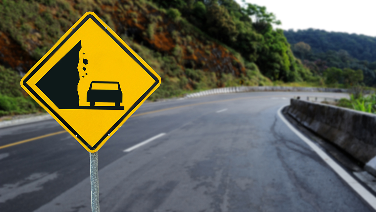
Landslides
Using Model-Based Inquiry to Investigate Local Mass Wasting Events
CONTENT AREA Earth Science
GRADE LEVEL 6–8
BIG IDEA/UNIT Geoscience processes
ESSENTIAL PRE-EXISTING KNOWLEDGE Students should have explored the properties and formation of rocks, minerals, and soil.
TIME REQUIRED Five 70-minute classes or 350 minutes
COST Around $30 for a class of 30
SAFETY Wear safety goggles; keep hands away from faces, eyes, and mouths; keep pathways clear and report all incidents, clean water spills immediately; keep hands away from rocks when striking them; clean workstations after each investigation.
Landslides present an excellent phenomenon with which to engage students in learning science in a manner that is locally relevant. Landslide refers to a wide variety of mass wasting processes that result in the downward and outward movement of slope-forming materials including rock, soil, artificial fill, or a combination of these. Landslides include slumps, avalanches, rock falls, mudflows, and more (United States Geological Survey [USGS] 2004). Landslides occur in all 50 states and combine to represent the most economically significant natural disasters (USGS 2004). In the United States alone, mass wasting events cause more than $3.5 billion in economic loss and claim 25–50 lives annually (USGS 2004). Worldwide losses tally thousands of lives and billions of dollars annually. Furthermore, most cases could be averted with basic geological knowledge and preventative measures.
In this article, we share how we used a model-based inquiry (MBI) to teach middle school students about landslides in a weeklong summer camp. In MBI, students “explore phenomena and construct and reconstruct models in light of the results of scientific investigations” (Oh and Oh 2011, p. 22). They use science and engineering practices to develop models that showcase their understanding of science concepts (Oh and Oh 2011; Windschitl, Thompson, and Braaten 2008). Neilson, Campbell, and Allred (2010) described a roadmap for a multidirectional cycle of MBI consisting of three components: modeling, focused inquiry, and iterations. As students model a phenomenon, they individually create diagrams and written explanations to represent their understanding of how and why the phenomenon happens. Then, in a series of focused inquiry investigations, students develop questions, design and conduct experiments, and construct evidence-based explanations for different elements of the phenomenon. Finally, and through iterations, students integrate their evidence-based explanations to refine their initial model of the target phenomenon.
We partnered with a university center and local school district to offer the camp as part of a junior high’s summer school program. The format of the camp allowed us to teach this unit to two different classes of students. In what follows, we describe the day-by-day MBI activities that we used to support students’ development of a model to explain how and why landslides happen. Students worked in groups of two to three throughout the MBI unit.
We began the unit by engaging students with landslides that had recently occurred in our local region of southeastern Ohio. Students made observations about two road images (see Figure 1) and a news video depicting different landslides (see Trimble rockslide in Online Resources). They inferred that these landslides occurred because of several characteristics or causes: a hilly/mountainous landscape, weather/climate factors like wind and rain, and geological processes like earthquakes. The introduction sparked students’ interests; they shared stories about their recent
experiences and ones they heard about in their community. We encouraged students to observe all elements in the images (e.g., people, cones, ropes, and emergency vehicles) and discuss their social and economic implications, including safety. Images demonstrating road-cut failures, liquefaction events, or mud flows could also equally engage students and introduce the unit.
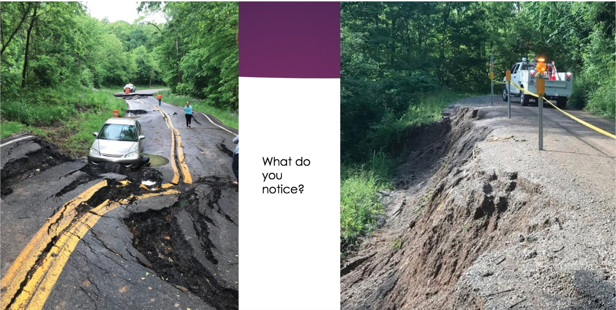
Landslide examples for introductory discussion. Left panel: vehicle stuck on a landslide-damaged portion of highway after driver drove around barricades into the closed work zone in Washington County, Ohio. Right panel: Slump caused by flooding undercutting the banks in Athens County, Ohio.
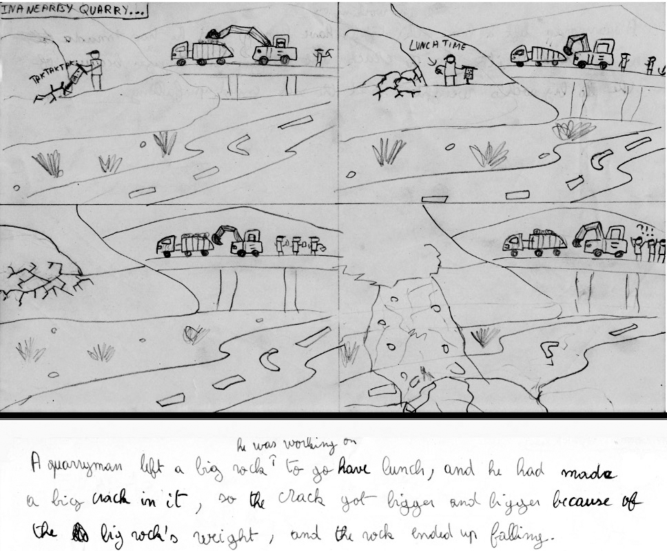
To begin modeling why and how landslides occur, we encouraged students to draw diagrams and write statements describing their thinking about the relationships between their shared characteristics and the likeliness of landslides occurring. Most commonly, students stated: “More landslides occur in hilly areas than in areas that are not hilly,” “More landslides will occur when it rains hard,” and “There will be more landslides on higher mountains.” Less common statements include: “Without good planning, homes and roads can be built in a way that makes an area less stable.” Students’ diagrams consisted of landscapes with mountains and rain, back-and-forth arrows representing earthquakes, or overhangs and rocks ready to roll. Figure 2 presents an example of an eighth grader’s initial model about how human activity can affect landslides. The model in Figure 2 describes the role of forces explicitly (e.g., weight). We created a class list of statements and invited all students to note similarities, differences, and ideas they were unsure about. We did not evaluate students’ ideas or differentiate between conditions (e.g., steep slopes and saturated ground) and triggers (e.g., vibrations, heavy rainfall, and oversteepened slopes) of landslides. Students used the class list to generate science questions to guide class investigations and help them better describe and explain how and why landslides occur (e.g., How does rain affect landslides? How does height affect landslides?).
After completing the initial modeling activity (approximately 30 minutes), we introduced mass wasting as the geological term used to denote earth processes that include landslides (e.g., falls, topples, slides, spreads, and flows) and showed students a map depicting the regions of the state with the highest incidence of landslides. We explained that our goal for the week was to develop a model that explains how and why landslides like the ones we observed occur. We also explained that students would be able to use their models to determine what makes certain regions more prone to landslides and to predict when a landslide might occur. We discussed how professionals (e.g., geologists and other scientists, engineers, builders, city planners, etc.) study landslides and use knowledge about them to make decisions to prevent human-caused landslides and minimize their economic, ecologic, and loss of life impact.
Focused Inquiry 1: Slope and mass wasting (Day 2)
For the first focused inquiry, students worked in groups of 2–3 (by grade level) to investigate their questions and claims about the impact of topography on landslides. We chose this focus because students shared different and incorrect ideas about steepness and elevation, with some stating that landslides occur more frequently on higher hills or mountains. Over a period of 50 minutes, students conducted an investigation using a rain gutter and debris to observe the behavior of different types of debris (loose slope materials) on hills or mountains of varying steepness. They took on different roles, including manager, investigator, and recorder. Managers gathered and returned equipment and materials; investigators conducted the investigation and kept the group on task; and recorders recorded data and kept notes on the investigation. Group members rotated the roles among themselves as they tested each type of debris. To begin their investigations, managers collected Inquiry 1 materials, which included potting soil, sand, gravel, gutter pieces, plastic bins, scales, and measuring cups. Then, each group set up a mini-landslide model as their testing station (see Figure 3). As a safety precaution, we required students to wear goggles and instructed them to keep their hands away from their faces, eyes, and mouths.
Sample initial model of a landslide developed by an eighth-grade student.
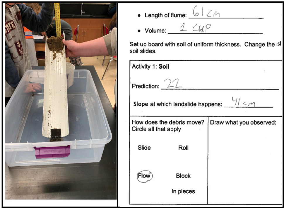
Mini-landslide model setup and example student work for Focused Inquiry 1: Slope.
Because we did not have a sense of students’ learning needs prior to this activity, we structured the first inquiry as a guided investigation and provided students a handout. In their groups, students generated predictions, planned their experiment(s), and were required to check in with instructors prior to beginning their experimental work. Their plans identified their independent variables (e.g., soil, sand, gravel, or some combination), controls and constants (e.g., amount of debris by volume or by mass, location of debris on gutter), dependent variable (the point at which a landslide occurs, slope is a proxy measure for this variable), and procedures. To support students’ sense making, we asked them to observe the different types of debris and compare the size of their particles. We also discussed the importance of controlling variables and how, for example, using different amounts of debris in each test may affect the results. To help students connect steepness to slope rather than height, we used the gutter to demonstrate the difference between height and slope, to explain rise (height at which landslide happens) and run (length of the gutter or flume), and then to describe how rise and run measurements are used to calculate slope. We also encouraged students to think about steepness in terms of how small or large the angle between the bin and their gutter was.
After groups completed data collection and cleanup, they analyzed their data by comparing their results for the different types of debris, creating graphs, and looking for patterns and relationships (e.g., soil failure occurred at the highest slope and gravel at the lowest; the smaller the size of the individual particles, the higher the slope at which debris fell). We used McNeill and Krajcik’s (2012) framework for scientific explanations (claims, evidence, reasoning) to scaffold students’ answers to the science question, “How stable are different debris types on hills or mountains of varying steepness?” To debrief students’ work and extend data analysis, we used a class graph representing all groups’ results to discuss and identify patterns or relationships (materials fail as slope increases; materials with larger size particles failed more readily). To support students’ sense making, we asked them to use their observations of particle size and shape to explain the different angles at which they fall. We concluded this phase of the MBI by discussing the underlying mechanisms (things we cannot see) that could help explain how landslides occur: forces acting on the debris (gravity/weight, normal force, friction, and forces as vectors) and how these forces changed as slope increased (net force). We asked students to draw their mini-model and the forces they believed were driving the landslide they observed. Some students used downward arrows to represent weight. We used this opportunity to introduce force diagrams and describe how they are used to represent the forces acting on the debris (e.g., weight). We presented the idea of the normal force as a force that counteracts weight and keeps the debris in place. Modeling forces in this manner allowed students to discuss and represent (without trigonometry) the impact of a downward net force on landslides and slope stability irrespective of type of debris.
Focused Inquiry 2: Water and mass wasting (Day 3)
To help clarify the impact of water (amount and rate of fall) on landslides, groups (same as Day 1) designed and conducted experiments to answer the question, “How stable are the different debris types during rain events?” They used the roles, materials, and mini-landslide slide models from Focused Inquiry 1, as well as graduated cylinders and spray bottles. In addition to the safety precautions previously described, we included the importance of taking action to immediately clean water spills. Students had more control over this phase of the inquiry. They identified their variables (e.g., independent, dependent, and constant variables), how they would measure the dependent variable (the point at which a landslide occurs, amount of water is a proxy measure for this variable), and how they would record their data. Students who needed more support were provided a more structured handout to scaffold data collection. Some students had difficulty recognizing that slope should remain constant. We asked them which variable (type of debris or slope) they thought was causing the change in the volume of water needed for the landslide to happen; helped them recognize that changing the slope would add an independent variable to their investigation; and discussed the importance of controlling variables to avoid various explanations for the differences in amount of water needed for a landslide to happen in each type of debris.
Other students struggled with measuring volume of water using graduated cylinders (e.g., calculating the amount of water that was used by subtracting the volume remaining from the initial volume). To help students distinguish between volume used and volume remaining, we asked them to consider what the volume of water at which a landslide happens would be if they used all the water they started with and the cylinder was empty. When students recognized that the volume could not be zero, we asked them to talk about what the measurement of zero represented (water remaining or not used) and how much water was used before the landslide happened. After students realized that their starting (initial) volume of water was the volume used in this scenario, we asked them to describe the initial volume and volume remaining in their investigation and talk about how these measurements can help them figure out volume used.
After data collection and cleanup (approximately 50 minutes), groups analyzed their data by comparing their results for the different types of materials, comparing their group findings to those of other groups, and identifying patterns or relationships (which materials failed more readily; as the amount of precipitation increases, the likelihood of landslide increased for each material). As students developed their science explanations, we asked them to consider the forces (e.g., weight and friction) acting on debris and how forces can change as a result of rain events. We also helped students relate their observations about the behavior of water and debris during the landslide events to some of their characteristics (e.g., particle size, amount of pore space between particles, surface tension). For example, students observed that water immediately and more easily flowed between the pieces of gravel. Conversely, sand and soil were able to hold some water (soil more so than sand) before it flowed through the debris. Students also observed that when sand failed, most of it washed out, whereas soil failed in batches.
Up to this point in the MBI, students used mini-landslide models to examine how topography (slope) and weather (rain) affected the forces acting on surface level “loose” debris, causing landslides. They observed the impact of vibrations on landslides when we shook the gutters, hypothesized the effect of doubling the amount of debris, and discussed how the mini-models can help scientists understand the different conditions and results from real landslides. Some of these experiences were preplanned (e.g., discussing the affordances of mini-models), and others emerged as students conducted their investigations. For example, on Day 2, one group wondered how shaking the gutter affects the slope at which the soil falls. We invited all groups to shake their gutters and observe what happens. Students noted that shaking the gutter triggered the soil to fall at a lower slope. They inferred what the shaking or vibrations could represent (e.g., earthquakes, excavations, mining). Because of our limited time with students, additional factors and conditions (e.g., low vegetation) were not the subject of focused inquiries.
Focused Inquiry 3: Materials and mass wasting (Day 4)
We started this inquiry by revisiting the landslide phenomena (images and video) from Day 1 and highlighting that, during landslides, parts of cliffs, hills, and mountains break away along with loose debris. We posed the question: Are some types of bedrock more prone to landslides than others? To answer this question, students individually investigated the impact of rock strength (or competence) on slope stability (approximately 45 minutes). Using magnifying lenses, students made observations about the color, texture, and grain size of different types of local sedimentary rock samples and recorded their observations on a handout. Sample observations include:
- Conglomerate samples have the largest grain size, are rough to the touch, and are made of smaller rocks the size of gravel or popcorn kernels.
- Sandstone has a much smaller grain size than conglomerate (similar to salt or sprinkles). Individual sand grains are observable. Sandstone feels rough like sandpaper.
- Siltstone has fine grain size. Individual grains are not observable. It feels smooth to the touch but gritty on teeth.
Using these observations as a basis, students made predictions about the strongest and weakest rock type as well as which would be the most or least resistant to landslides. Overall, sandstone and limestone were described as the strongest and most resistant rocks because of their larger grain sizes and welded nature, respectively. Shale and siltstone were described as the weakest and least resistant rocks because of their finer grain sizes. We took students outside to test their predictions. While wearing goggles and observing proper safety precautions (e.g., keeping hands away from the rocks), students took turns striking each of three rock types (limestone, shale, sandstone) with a hammer and recorded their observations about how much effort each rock required to break and what the broken pieces looked like (see Figure 4). Students observed that shale was the easiest rock to break and that it split into layers. Sandstone was next, breaking into smaller pieces and releasing sand grains. Limestone was the hardest to break. To help students connect their findings from this focused inquiry to the phenomenon of landslides, we asked them to think about elements in nature that can act like a hammer (e.g., earthquakes, vibrations due to blasting and construction, and weathering). We additionally explained that some sedimentary rocks like sandstones are permeable (allow water to easily flow through) and that very thinly layered rocks like shale allow water to flow between the layers. Both these properties contribute to the weathering of rock. We concluded this phase of the MBI by examining how extensive sedimentary rocks are across North America using a countrywide geologic map (see Online Resources) and then noting how the distribution of landslides in Ohio mirrors the prevalence of shale in the state, and particularly in our region, using the state bedrock geology map (see Online Resources).
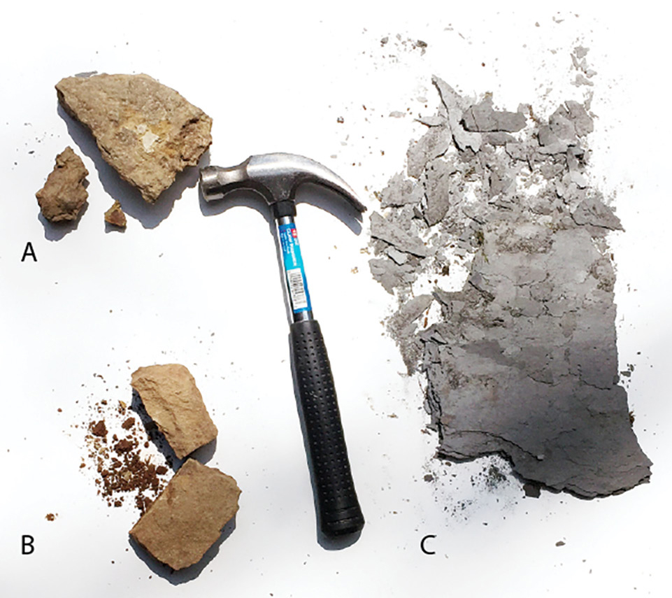
Examples of rock fragments produced from striking hand samples with the rock hammer. A: limestone breaks cleanly into large chunks. B: sandstone breaks into sand-sized grains. C: shale breaks into clay-sized particles and thin rock layers.
Iterations (Day 5)
On the last day of camp, students revisited the models they developed on the first day. They worked in their Day 2 and Day 3 groups to update their models by integrating their findings from the three focused inquiries and adding information to reflect their current understanding of how and why landslides occur. To help with model development, we asked students to think about what they learned about landslide conditions (e.g., steep slope, long periods of rain or periods of heavy rainfall, incompetent rock), triggers (e.g., vibrations, oversteepened slopes due to human activity or weathering, increased weight on slope due to water saturation), and underlying mechanisms (e.g., net force due to gravity/weight in the direction of the motion, reduced friction, weakened cohesive forces in rock binding) from each focused inquiry. Groups developed their models on charts and posted them around the classroom (25 minutes). Through a gallery walk, students spent approximately 15 minutes observing the work of others and noting similarities and differences between their models. Students tested their models’ ability to explain why and how the landslide phenomenon depicted in the news video from Day 1 occurred. They used them to predict the behavior and outcome of new experiments (e.g., rain on a well-vegetated slope vs. one with low vegetation). This phase presents an opportunity to check on students’ developing understanding, help them identify and evaluate competing ideas, and engage in additional model development iterations. At the conclusion of the MBI, students individually completed the landslides model paper (see Figure 5), which served as the summer camp summative assessment. An example of a student’s final model is provided in Figure 6.
Instructions and evaluation criteria for the landslide final model.
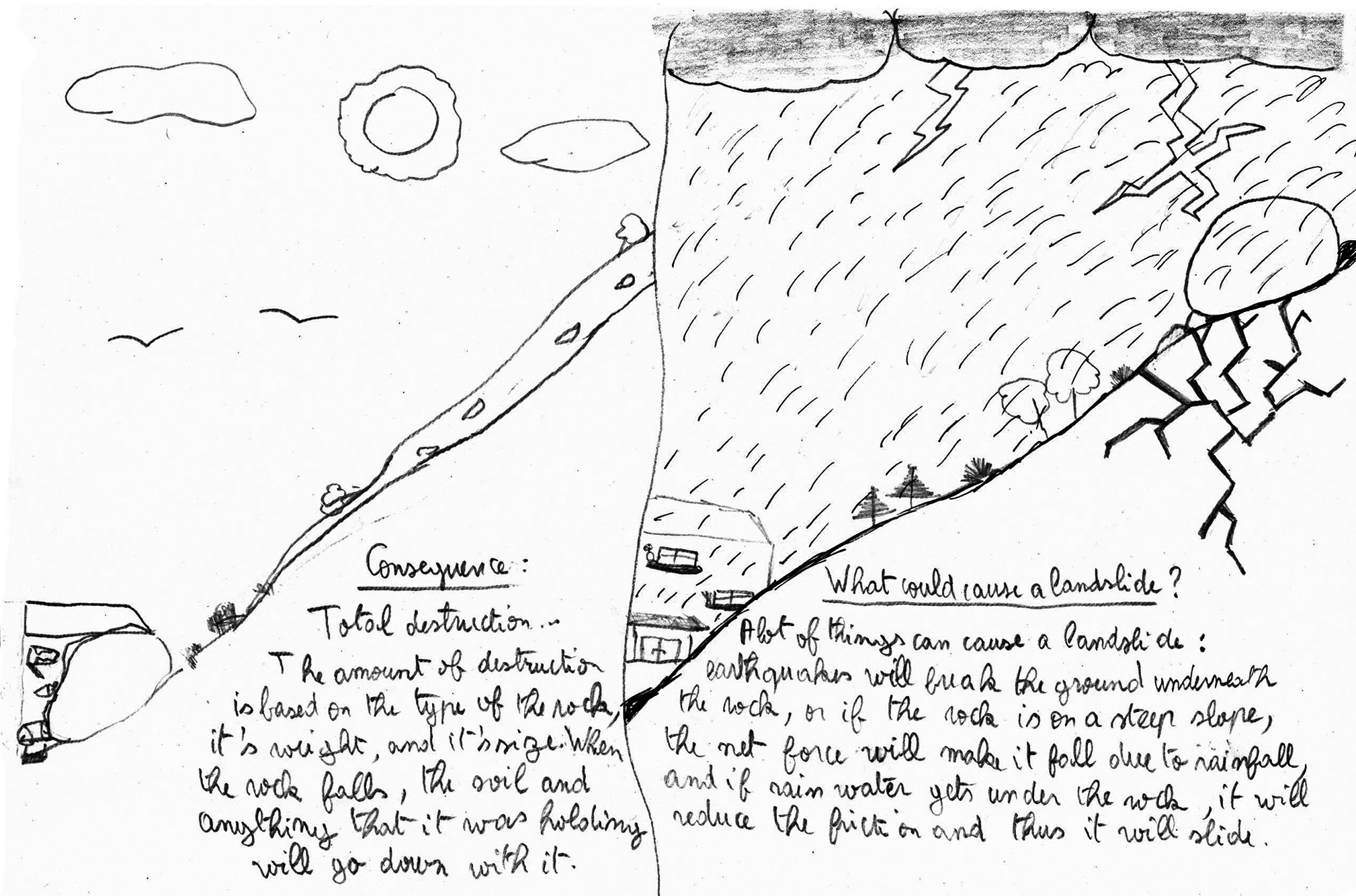
Sample final model of a landslide developed by an eighth-grade student.
Conclusion
The middle school students who participated in summer camp developed a model for how and why landslides happen using explicit model-building opportunities and a series of structured, guided, and open inquiries. Our summer camp was only one week long. With more time, we would engage students in additional focused inquiries, including an engineering design challenge to use model houses to test locations within a created landscape that would allow a house to better survive a landslide event (see mini-landslide activity in Online Resources). The place-based nature of this MBI provided students a high cognitive demand experience to learn about landslides as phenomena that are very prevalent in the region of the United States in which they live. As a transdisciplinary experiential approach, place-based education focuses on local or regionally characteristic natural and social settings that are more meaningful to students because they are connected to places they know (Buxton and Provenzo 2012; Sobel 2004). As students engage in place-based MBI investigations, they dialogue and think deeply about their science ideas; use their findings, prior knowledge, and prior experiences to develop new understandings; and engage in informed decision-making about issues in their community and others that are more widely relevant. •
Online Resources
Countrywide geologic map—https://pubs.usgs.gov/imap/i2781/
Mini-landslide activity—https://www.teachengineering.org
State bedrock geology map—https://geosurvey.ohiodnr.gov/portals/geosurvey/PDFs/BedrockGeology/BG-1_8.5x11.pdf
Trimble rockslide [television news report]—https://www.youtube.com/watch?v=__5TOBbxP8w
Online Resources about mass wasting
USGS Fact Sheet: Landslide Types of Processes—https://pubs.usgs.gov/fs/2004/3072/fs-2004-3072.html
U.S. Geological Survey Landslide Program—http://landslides.usgs.gov
U.S. Landslide inventory—https://usgs.maps.arcgis.com/apps/webappviewer/index.html?id=ae120962f459434b8c904b456c82669d
For assessment of landslide risk to an individual property or home site, find professionals through the membership listings of the American Society of Civil Engineers (https://www.asce.org) and the Association of Engineering Geologists (http://www.aegweb.org)
For information on slides, debris flows, rock falls, or other types of landslides in your area, contact your city or county geology or planning office, or see state geological surveys—http://landslides.usgs.gov
For information about the design and construction of debris-flow mitigation measures, consult your city or county engineer, local flood-control agency, or the U.S. Department of Agriculture’s Natural Resources Conservation Service—http://www.ncgc.nrcs.usda.gov/
Photos of landslides—USGS Circular 1325: The Landslide Handbook—A Guide to Understanding Landslides—https://pubs.usgs.gov/circ/1325/
Publications on the processes of landslides: D.J. Varnes, 1978, “Slope Movement Types and Processes”—https://trid.trb.org/view/86168; and K.A. Turner and R.L. Schuster, 1996, “Landslides: Investigation and Mitigations”—http://onlinepubs.trb.org/Onlinepubs/sr/sr247/sr247.pdf
Supplemental Materials
Danielle E. Dani (dani@ohio.edu) is a professor in the Department of Teacher Education and Alycia L. Stigall is a professor in the Department of Geological Sciences, both at Ohio University in Athens, Ohio.
Earth & Space Science Inquiry Phenomena Science and Engineering Practices Teaching Strategies Middle School Informal Education