
feature
Moving Continents
A Middle School Plate Tectonics Unit
Science Scope—November/December 2020 (Volume 44, Issue 2)
By Jeff D. Thomas, Sally Valentino Drew and Kelsey Constantino
CONTENT AREA Earth Science
GRADE LEVEL 6–8
BIG IDEA/UNIT Plate tectonics
ESSENTIAL PRE-EXISTING KNOWLEDGE Lithospheric plates, plate boundaries, climate, dinosaurs
TIME REQUIRED Approximately fourteen 50-minute class periods
COST None, if you have access to computers
SAFETY One lab uses hot water, but it is a teacher demonstration
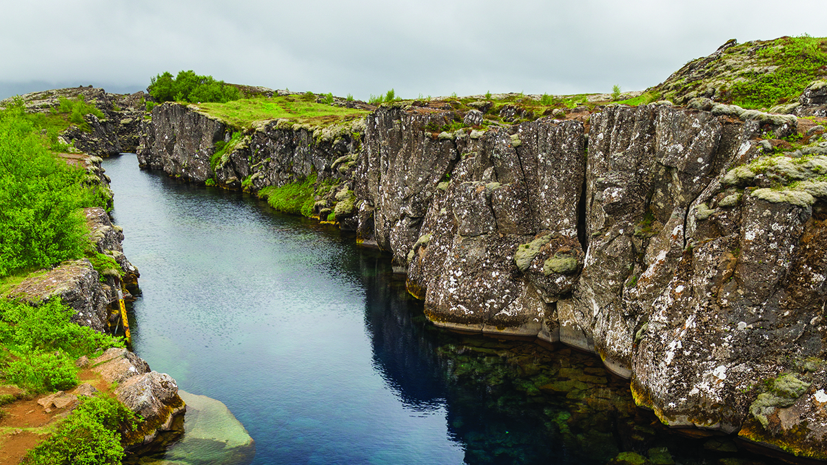
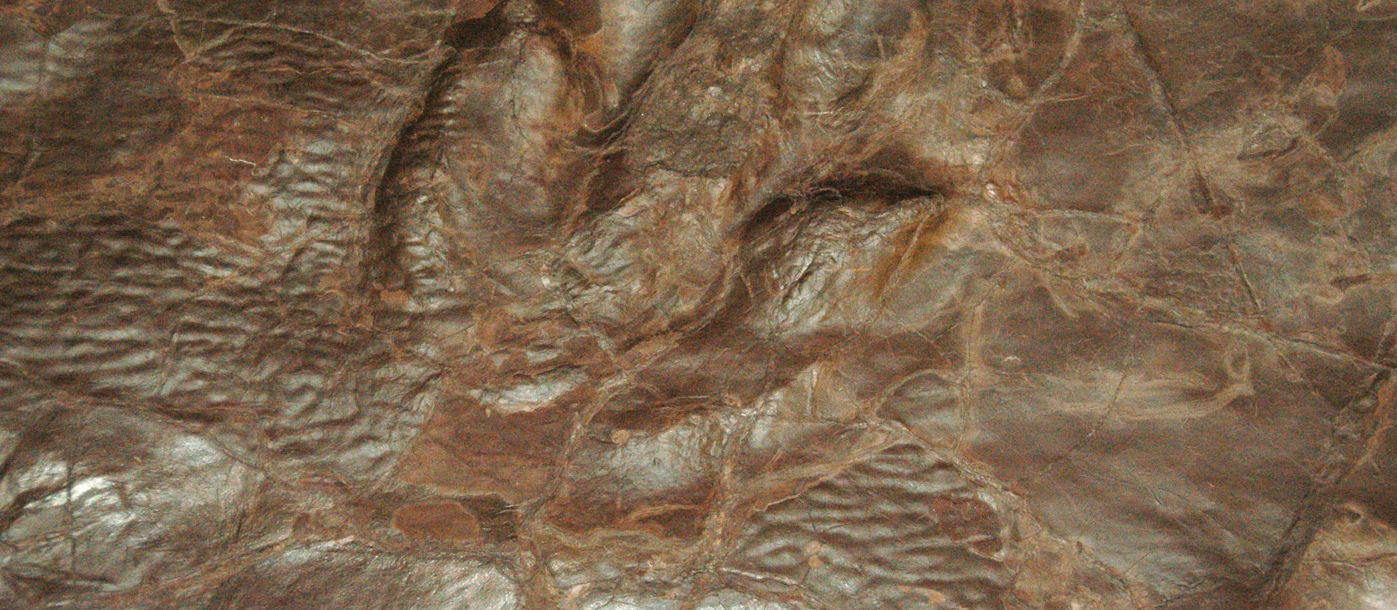
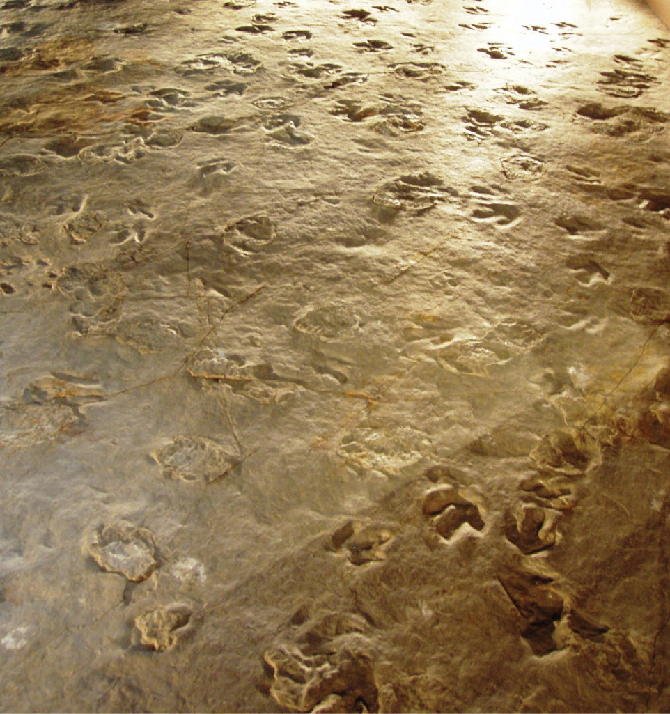
Plate tectonics, a major science theory, describes large-scale motion of Earth’s lithospheric plates over millions of years to explain science ideas such as formation of mountains and oceans and the changing positions of Earth’s landmasses. Teaching middle school students about plate tectonics is challenging because of the abstract nature of the large spatial scale of the continental and oceanic plates as well as the slow temporal movements of these plates. Thus, selecting a unit-level anchoring phenomenon that students could observe to form testable explanations and predictions about plate tectonics was crucial. We wanted the anchoring phenomenon to be accessible to students, related to their real-world experiences, and puzzling enough for students to want to pose quality scientific questions and seek explanations (Windschitl et al. 2012). After considerable brainstorming, we selected one of Connecticut’s most famous geologic discoveries to engage students—over 2,000 prehistoric fossilized dinosaur footprints from the Jurassic period (see Figure 1), one of the best collections of its kind.
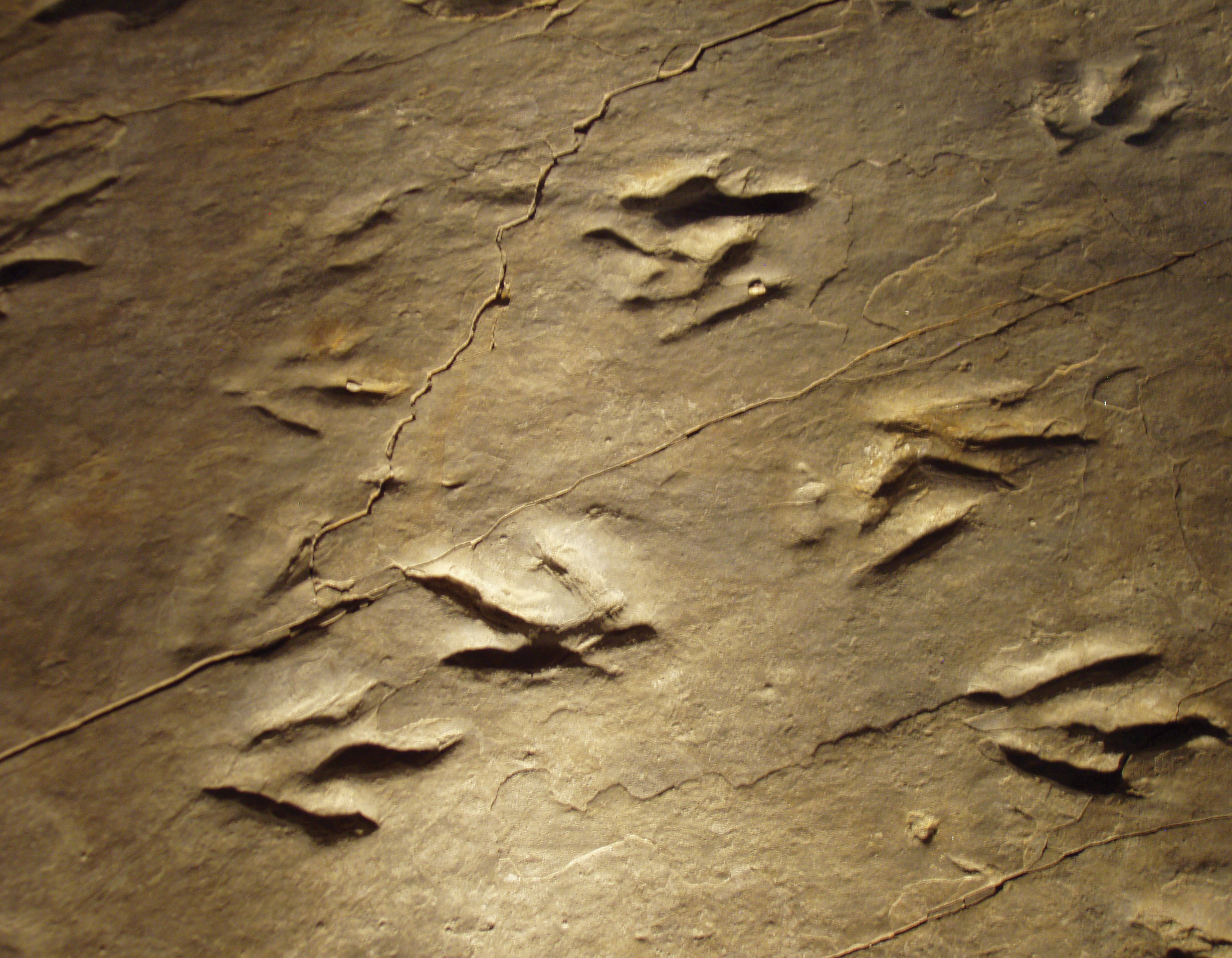
Eubrontes fossil footprints in Rocky Hill, Connecticut.
The Eubrontes footprints from Dinosaur State Park in Rocky Hill, Connecticut were selected because dinosaurs are captivating to most students. In fact, many Connecticut children have visited this park either with their parents or during school field trips. The puzzling aspect was not the prints themselves, but rather the environment in which these prehistoric animals lived. Approximately 200 million years ago, as the supercontinent Pangea was breaking up, Connecticut’s geographic position was situated closer to the equator, which resulted in a hot and humid climate with many tropical plants and animals. We felt these differences were accessible to students because they were familiar with Connecticut’s present-day climate and would be puzzled as to how it could have been tropical, leading to their questioning how this could have happened.
The unit goal was for students to propose a well-developed scientific explanation of how Connecticut’s climate and landscape changed over millions of years, citing plate tectonics as the underlying theory. In this article, we describe implementation with suburban sixth graders, although the unit was designed for any middle school student. Student handouts for each of the eight investigation activities from the Plate Tectonic (PT) Unit (labeled as PT Unit Student Handouts), and a teacher handout to help implement the embedded literacy strategies within the unit (labeled as For the Teacher: Literacy Strategies) can be downloaded as MS Word files (see Online Supplemental Materials).
Engage
Investigation 1: What did prehistoric Connecticut look like?
We started this one-day lesson by having students observe fossilized dinosaur footprints from Dinosaur State Park (see Figure 1) and posed a driving question to students: What did prehistoric Connecticut look like? Students then read an article called Digging Up Dinosaurs in Connecticut that highlighted how the footprints were discovered and how they got there (see Resources). Using a think-aloud reading strategy (see For the Teacher: Literacy Strategies in Online Supplemental Materials), we read the article to students as an expert reader, which allowed them to hear how key points of the article, such as Connecticut’s tropical climate, are identified and described. Students then completed an I Think, We Think chart (see For the Teacher: Literacy Strategies in Online Supplemental Materials) that describes what prehistoric Connecticut may have looked like; student responses included that it was warmer, wetter, and had more mud, among other statements.
To highlight the differences between prehistoric Connecticut and today, students read a second article, Fossils of the Connecticut River Valley (see PT Unit Student Handouts in Online Supplemental Materials), which was modified for the reading level of our sixth graders. An electronic version of the article, with weblinks, provided struggling readers background information on difficult vocabulary and concepts. Independently, students used the text-coding reading strategy (see For the Teacher: Literacy Strategies in Online Supplemental Materials) as they read science information that confirmed or refined their ideas about prehistoric Connecticut (e.g., variety of tropical animals and plants, weather conditions). After sharing with the class, students drew a visual of what they thought prehistoric Connecticut looked like, which was clearly different from today’s temperate conditions.
In small groups, students brainstormed probable factors such as meteor impacts or climate change to explain why prehistoric Connecticut was more tropical when dinosaurs roamed. A Gotta-Have-It Checklist (see For the Teacher: Literacy Strategies in Online Supplemental Materials) provided students with a list of criteria that included (1) the location of Dinosaur State Park, (2) observable and unobservable parts of the phenomenon, (3) time passing (i.e., the time when the dinosaurs left the prints and today), and (4) the possible mechanisms that lead to the change. Using the checklist, students constructed a preliminary science model to explain why prehistoric Connecticut was so different than today. For example, one student group made a conceptual drawing that depicted the Connecticut landscape with many dinosaurs and tropical plants. The naïve and incomplete mechanism students included to explain the warm climate was the dinosaurs exhaling carbon dioxide. Because this was their initial model, suggestions were not yet provided to improve on the model, as students would make modifications as they progressed throughout the unit, adding to their conceptual understanding and resolving initial misconceptions.
Explore
Two inquiry-based Explore activities provided sixth graders with common experiences from which to investigate preliminary evidence to justify how landmasses shifted geographical positions and to explain why Connecticut used to be in a tropical climate zone.
Investigation 2: Wegener’s prehistoric fossils
This two-day activity was substantially altered from the U.S. Geological Survey’s (USGS) published lesson titled Wegener’s Puzzling (see USGS: This Dynamic Planet in Resources) to make it more challenging and to align more closely with three-dimensional learning. The goal of this modified investigation was for students to uncover that continental landmasses have shifted over time. Students were asked to assist Alfred Wegener, investigating his hypothesis that the continents shifted geographical positions from what we know today as Pangaea. This was speculated from the fossil evidence he collected—which was puzzling to Wegener. The original activity included a map of five unconnected continental landmasses (South America, Africa, India, Australia, and Antarctica) with shaded areas where four sets of fossils were located. The task was for students to cut out five landmass pieces and put them together into one supercontinent landmass. To make this more inquiry-based, we created an original handout titled Wegener’s fossil field notes (see Figure 2) that listed the four fossils and the countries and cities where they were located. We also altered the original landmass map by removing the shaded fossil areas. With these changes, small groups of students used the field notes coupled with Google Maps to identify and shade in the areas where the fossils were located on each landmass. Next, after cutting out the landmasses, students then aligned the fossil evidence from each landmass along with the shapes of them to create one landmass of best fit (see Figure 3). Some groups struggled with positioning the landmasses together, so we circulated the room and provided prompts. For instance, one group struggled with placing India and Antarctica together, and we emphasized how they needed to closely analyze the fossil evidence to fit them together as one supercontinent, which helped students meet the expectations of this task.
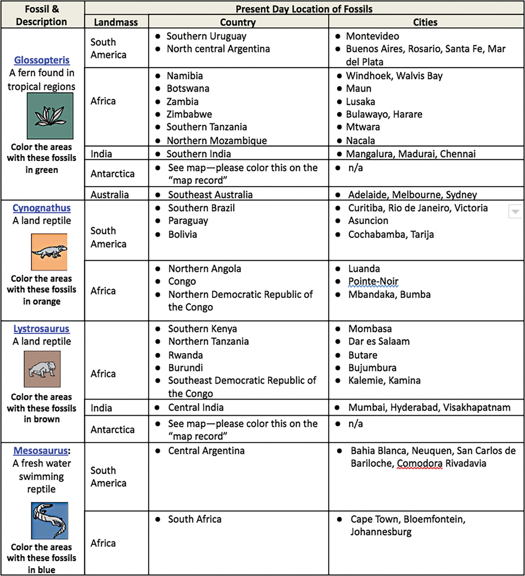
Wegener’s Triassic fossil field notes.
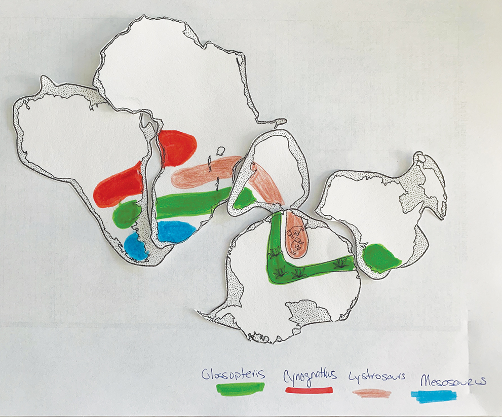
Example of a completed version of Wegener’s continents
As an informal assessment the following day, groups shared their work (e.g., see Figure 3) with the class. Using the Talk Moves literacy strategy (see For the Teacher: Literacy Strategies in Online Supplemental Materials), another modification from the original activity, sixth graders presented one landmass of best fit and noticed they all had similar results—with slight variations. Students were prompted to share out in the discussion and justify their decisions. We asked students questions as a way to scaffold and guide the conversation. An example prompt we asked was: “Mary, do you agree with the way Colin and his group aligned Antarctica and India?” Students explained and argued their findings to deepen their understanding about how the continents were once together and how they may have moved.
Next, groups of three or four students were given the Unit Summary Table (see Figure 4) and asked to complete the first row. This graphic organizer had four columns: (1) unit investigations, (2) evidence of what happened (e.g., data), (3) factors/mechanisms to explain what happened, and (4) how the evidence helped figure out the unit phenomenon. The Unit Summary Table (see Figure 4) writing- to-learn strategy keeps track of students’ sensemaking for each activity of the unit, as they add to their unit-level explanation of how Connecticut transitioned from a tropical to a temperate climate. As such, after each unit investigation activity, students filled out the entire row of what they learned from the activity in each of the three columns.
Unit Summary Table: Why was Connecticut tropical when dinosaurs roamed the Earth?
|
Unit activities These are the investigations we did. |
Data patterns & observations Record the evidence of what happened. |
Why What factors/mechanisms might cause these patterns? |
Clues How does this help us figure out the unit phenomenon? |
|
Investigation 2: Wegener’s prehistoric fossils |
|
|
|
|
Investigation 3: Earth’s plates and plate boundaries |
|
|
|
|
Investigation 4: Do plates move? |
|
|
|
|
Investigation 5: How fast do plates move? |
|
|
|
|
Investigation 6: What moves Earth’s plates? |
|
|
|
|
Investigation 7: How did Connecticut move? |
|
|
|
Investigation 3: Earth’s plates and plate boundaries
Designed originally for college-aged students, Discovering Plate Boundaries (see Resources) was modified into a four-day, inquiry-based jigsaw activity for sixth graders. The goal was for students to independently discover plate boundaries—converging, diverging, and transform fault (Sawyer et al. 2005). For this investigation, students were only required to describe these terms in their own words before they were formally introduced to them during the next investigation.
The first day, we created a short, student-friendly PowerPoint (see PT Investigation 3 PowerPoint in the Online Supplemental Materials). First, we introduced students to two distinct vocabulary terms: plate and plate boundary. Students often confused lithospheric plates, an entire section of the Earth’s crust, with plate boundaries, which is the border between plates. This was an important distinction because the geologic data was focused along plate boundaries, and sometimes during the activity, students focused on the entire plate. Similarly, we introduced students to the geologic data central to this investigation that included: (1) the location and depth of earthquakes (e.g., foci), (2) the location of active volcanic activity, (3) topographic elevations (above and below sea level), and (4) the age of oceanic crust (see Discovering Plate Boundaries in Resources).
Next, students were organized into lab groups. They were given a global plate boundary map (see Discovering Plate Boundaries in Resources) and were assigned two or three lithospheric plates (e.g., South America, Nazca). Groups were then given the four geological data maps: (1) Seismology Map, (2) Volcanology, (3) Seafloor Age, (4) Topography/Bathymetry (see Discovering Plate Boundaries in Resources) and were asked to become familiar with them. Then, each member of the group selected which expert specialty they wanted to be—a semiologist, volcanologist, cartographer, or geochronologist. In these roles, each expert recorded three or more observations from their own specialty data map (e.g., earthquakes occur in narrow bands), and they shared their findings with the rest of group. This helped them all become familiar with the data.
The second day, lab groups were separated into expert specialty groups. Students were tasked to analyze their specialty map (e.g., earthquakes), identify the data patterns along plate boundaries, and construct a classification scheme based on these patterns. Students were not familiar with developing a classification system. To help them, we discussed biological taxonomy, which uses simple physical characteristics of organisms to identify and differentiate between species, specifically human beings and chimpanzees. We discussed similarities between these primates such as similar hands and feet, but we also emphasized distinctions such as humans being bipedal, which is what makes humans a different species from chimpanzees. This example helped students because they needed to look for unique patterns in the geologic data from their expert group to classify plate boundaries. Next, each expert group was given a transparency of the plate boundary map to overlay above the data map so students could better visualize how the geologic data (e.g., earthquake foci) aligned with the plate boundary. As expert groups collaboratively analyzed the data along all plate boundaries, they were required to independently develop three to five categories based on observed data patterns wherein they defined each one. For instance, one category was titled “narrow band of shallow earthquakes” and was described as “earthquakes found in the oceans that are shallow, less than 30 km deep.” Another example was “all depth earthquakes” and was described as “highly dense earthquake foci from 30 to 300 km deep.” When expert groups agreed on a scheme of three to five categories, they used markers to color their classified plate boundary map (see Figure 5). Expert groups often struggled with this activity, thus we closely monitored and prompted students to help them throughout the activity.
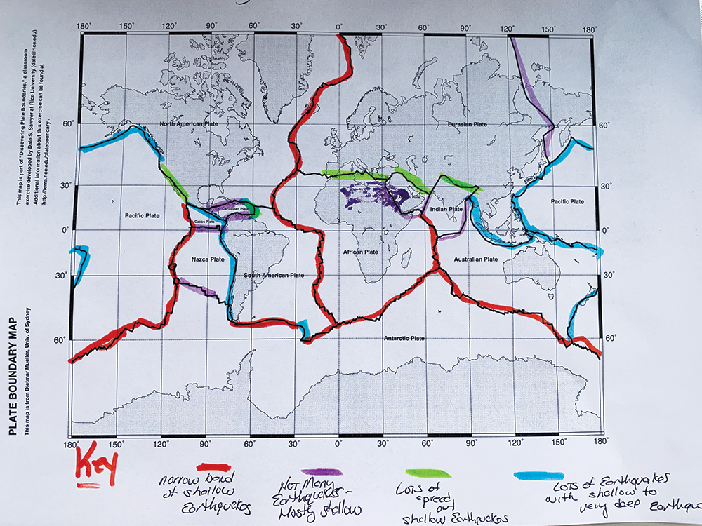
Student example of plate boundary map classified from earthquake data.
On the third day, expert groups shared their earthquake, volcanic, topographic, and geochronology classification systems with their original lab groups. Each lab group was then tasked to develop three to five new plate boundary classifications, similar to the previous step in their expert groups. This time, however, students had to synthesize all four geologic data sets (seismology, volcanology, sea floor age, and topography/bathymetry) into a newly defined plate boundary classification system. For instance, one classification scheme was “(1) shallow linear earthquakes, (2) few volcanos, (3) shallow ocean depth, and (4) young rock.” We found that if we started this task with a think-aloud (see For the Teacher: Literacy Strategies in Online Supplemental Materials) of how to classify a plate boundary, then students were more successful finishing the task.
The last day, we used the Talk Moves protocol (see For the Teacher: Literacy Strategies in Online Supplemental Materials) wherein lab groups justified their classification system based on the evidence they had been analyzing during a whole-class discussion. To do this, each group took a picture of their work and shared it with the class using a projector. Students discussed similarities and differences across groups, which helped them better understand the relationship among the data. Again, the goal was for students to “discover” the three plate boundaries—converging, diverging, and transform fault boundaries—which they often came very close to describing simply based on their classification systems. This was why it was easier to connect their ideas with the formal concepts during the next activity.
Explain
Three Explain activities developed students’ understanding of the dynamic nature of plate boundaries that led to deepening their understanding of plate tectonics. Students’ findings from each activity were included in the Unit Summary Table (see Figure 4).
Investigation 4: Do plates move?
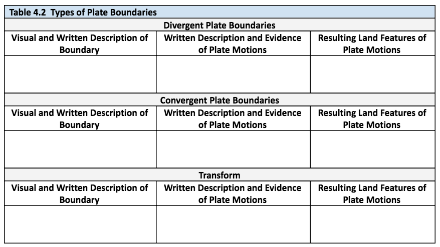
For this two-day activity (see PT Unit Student Handouts in Online Supplemental Materials) sixth graders were formally introduced to the names of the three major plate boundaries (i.e., divergent, convergent, and transform fault) and their dynamic nature, including what landforms result from the movements along these boundaries. After we provided students with a teacher version of a plate boundary map to compare with their own from the previous investigation, pairs of students read aloud an online USGS chapter (see USGS: Understanding Plate Motions in Resources) about plate motions. Using a modified version of the Paragraph Shrinking Strategy (see For the Teacher: Literacy Strategies in Online Supplemental Materials), students deepened their comprehension of the text and then decided what to write in a teacher-generated graphic organizer (see PT Unit Student Handouts in Online Supplemental Materials). For example, students read how the Mid-Atlantic Ridge was a divergent boundary that spreads slowly apart forming symmetrical underwater mountains.
Eubrontes theropod dinosaur track, Lower Jurassic; near Hartford, Connecticut
We also gave sixth graders data maps from Discovering Plate Boundaries (see Plate Boundary Data Maps [combined maps] in Resources) so they could self-assess what they learned from the reading considering their work from Investigation 3. This resource provided 15 examples of specific plate boundaries such as a map of the Aleutian Islands in Alaska, which is on a converging boundary. This map included all four data sets as described in Investigation 3, but on a single page. During a teacher-led discussion, we reviewed at least one example of each plate boundary, interpreting data from all four data maps. One such interpretation was that earthquakes along the Aleutian Islands occurred deeper below the surface and further from a plate boundary. We noted this indicated subduction, a term they just learned from the previous reading. This step clarified what students explored in Investigation 3 and helped them better understand how all four data sets related to plate motions and land formations. As a final assessment, students received a generic plate tectonic map and wrote a detailed explanation of plate boundaries, movements, and associated landforms (see Model Formative Assessment in Online Supplemental Materials).
Investigation 5: How fast do plates move?
For the next one-day inquiry-based activity, students confirmed the rate of motion of plate boundaries through computational mathematics. We developed two versions of this activity—the first was more challenging and required some technology skills, while the latter was a traditional paper-and-pen lab.
The first version required students to use GeoMapApp, an application that scientists use that can be freely downloaded and also used by students (see GeoMapApp in Resources). The central task for this activity was for students to find the age of ocean rock and the distance of this rock along the Mid-Atlantic Ridge, a divergent plate boundary, to calculate the rate of spreading. The tool itself required practice, but students determined the age and distance of oceanic rocks from spreading centers to calculate spreading rates as depicted in Figure 6. We provided concrete directions, with screenshots to support students (see PT Unit Student Handouts in Online Supplemental Materials). Alternatively, sixth graders could complete a paper-and-pen lab that was less technological and complex. This version titled The Race Is On With Seafloor Spreading (see Resources) asks students to calculate the spreading rates at predetermined locations from the East Pacific Rise, which was also less relevant to our Connecticut context.
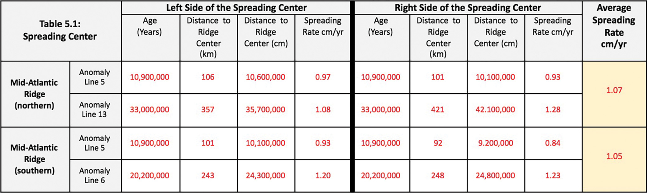
Calculating spreading rates from the Mid-Atlantic Ridge.
Investigation 6: What moves Earth’s plates?
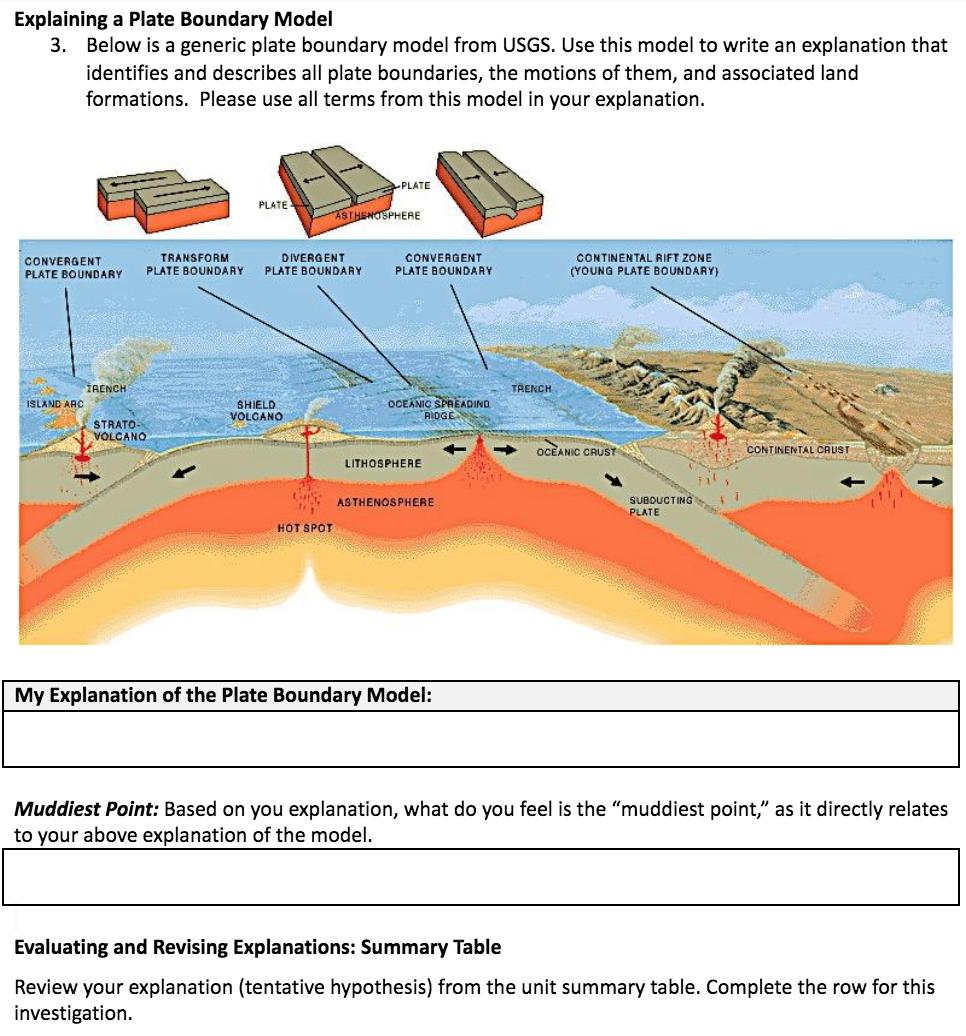
For the last one-day Explain activity (see PT Unit Student Handouts in Online Supplemental Materials), sixth graders learned the mechanisms that cause plates to move—the movement of fluid rock below the lithospheric plates that pushes them together, apart, or past one another. First, we conducted a teacher-led convection current demonstration at the teacher lab table in the front of the room. Wearing safety goggles, we placed room temperature water in a large container with floating pieces of paper (to represent plates). Then we placed ice cubes and a small beaker of hot water in the container that caused a convection current. Students made predictions, observed the convection current, and composed conclusions that cold and warm water mixing causes a circulation. For the second part of the lesson, students were given a handout of a USGS plate tectonic model with 14 numbers that identified model components (see page 7 of USGS: This Dynamic Planet in Resources) as well as converging and diverging plate movements. Students read another USGS chapter (see USGS: Understanding Plate Motions in Resources) where they completed a graphic organizer describing each labeled number. As a final assessment, students wrote an explanation of what causes plates to move, citing evidence from both the demonstration and from the USGS reading.
Elaborate
Investigation 7: How did Connecticut move?
For the two-day Elaborate activity (see PT Unit Student Handouts in Online Supplemental Materials), sixth graders applied what they previously investigated, read, and discussed about plate tectonics. The goal was for students to circle back to the anchoring phenomenon of the dinosaur prints and use evidence they learned throughout the unit and recorded on the unit summary table (see Figure 4) to explain why Connecticut’s climate and position changed from 200 million years ago to the present by constructing a final plate tectonic model.
We realized that asking students to complete this task would require significant scaffolding. So, as the first scaffolding activity, students watched an animation from the Dinosaur Database (see Resources), which depicted how plates moved, relative to Connecticut’s position, from 500 million years ago to the present. Using a graphic organizer, students described this plate motion, relative to Connecticut’s position, to help them visualize this dynamic process. For the second scaffolding activity, using the whiteboard, we constructed a converging plate boundary model as a class, using a teacher think-aloud to describe Connecticut’s collision as part of North America with Africa and Europe that formed Pangea.
Finally, students were then tasked to construct their own model to describe Connecticut’s split between North America with Africa and Europe that broke up Pangea 200 million years ago (see Figure 7). This assessment included a Gotta-Have-It Checklist that listed the criteria to be evaluated (see PT Unit Student Handouts in Online Supplemental Materials).
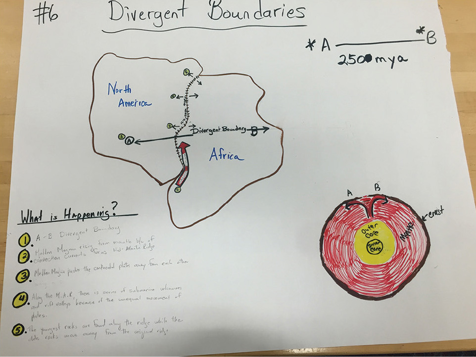
Example of a student final model.
Dinosaur State Park, Rocky Hill, CT
Evaluate
Summative assessment
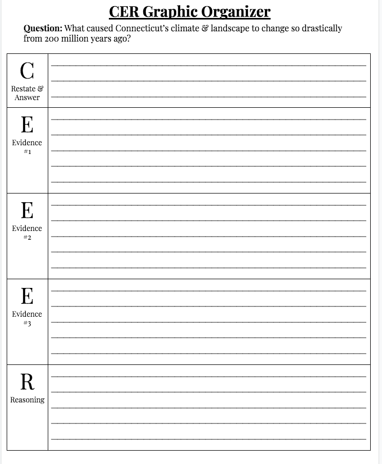
For the summative assessment, sixth graders independently wrote a claims, evidence, reasoning (CER) explanation essay to address the unit question: What caused Connecticut’s climate and landscape to change so drastically from 200 million years ago? This was linked to the original phenomenon wherein dinosaurs lived in a tropical climate compared with a temperate one today. To support students, we gave them a Gotta-Have-It Checklist (see PT Unit Student Handouts in Online Supplemental Materials) that identified key concepts they needed to include in their explanation: the layers of earth (e.g., mantle), convection currents, oceanic and continental crust, plate and plate boundaries dynamics, and landforms. In addition, sixth graders were given a CER Graphic Organizer (see Online Supplemental Materials) that provided space for them to record an overall claim, multiple sources of evidence, and reasoning while encouraging them to use their unit summary table as a resource (see Figure 4). We asked to see what students wrote in their organizer and provided feedback to them prior to their drafting a paper. For instance, many students overlooked the convection currents below Earth’s crust as the mechanism to cause the plate to move apart. Providing students an entire class period to draft their ideas supported them in writing a one- to two-page well-developed paper to answer the unit-level question, as evaluated by our assessment rubric (see PT Unit Student Handouts in Online Supplemental Materials).
Conclusion
Students were consistently engaged over the course of this middle school plate tectonic unit; the dinosaur context certainly helped keep them invested. Yet, the unit was also challenging—especially classifying plate boundaries, calculating spreading rates, and modeling and writing science explanations for why Connecticut’s climate and landscape changed so drastically from past to present. Although this unit was specific to Connecticut, teachers can select similar contexts in their own states. Some research may be required to develop a location-specific anchoring phenomenon, but teachers can use or adapt many of the activities presented here as part of their own unit.
Resources
Discovering Plate Boundaries—http://plateboundary.rice.edu/ for the main page and http://plateboundary.rice.edu/downloads.html for the data maps
Digging Up Dinosaurs in Connecticut—https://blog.ctnews.com/csc/2014/08/11/digging-up-dinosaurs-in-connecticut/amp/
Dinosaur Database—http://dinosaurpictures.org/ancient-earth#170; http://dinosaurpictures.org/
GeoMapApp—http://www.geomapapp.org/index.htm
Plate Boundary Data Maps (individual maps)—http://plateboundary.rice.edu/downloads.html
Plate Boundary Data Maps (combined maps)—http://plateboundary.rice.edu/all.4map.pdf
The Race Is On With Seafloor Spreading—https://joidesresolution.org/activities/seafloor-race/
USGS: Understanding Plate Motions—https://pubs.usgs.gov/gip/dynamic/understanding.html
USGS: This Dynamic Planet (see page 7)—https://volcanoes.usgs.gov/vsc/file_mngr/file-139/This_Dynamic_Planet-Teaching_Companion_Packet.pdf
Online Supplemental Materials
For the teacher: Literacy strategies
PT Investigation 3 PowerPoint presentation
Jeff D. Thomas (thomasjed@ccsu.edu) is a professor of science education in the Department of Geological Sciences and Sally Valentino Drew is an associate professor in the Department of Special Education and Interventions, both at Central Connecticut State University in New Britain, Connecticut. Kelsey Constantino is a teacher at Brownstone Intermediate School (Portland Public Schools) in Portland, Connecticut.
Earth & Space Science Inquiry Labs NGSS Phenomena Science and Engineering Practices Three-Dimensional Learning Grades 6-8